
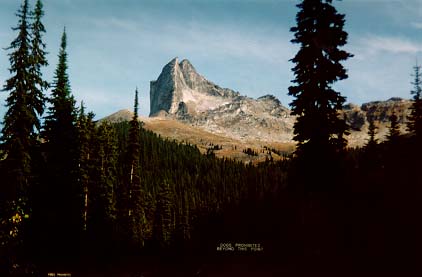
 This is the view at the start of our hike to Mulvi Basin. The group of us, Dave, Lincoln, John, Phil and I, left Grand Forks at 7:00 am, and drove 2 hours to the trail head. We hiked up through the trees, a steady incline, for about an hour. Then we hiked to the left of the base of Mount Gimli, around the left side of the mountain and down into the basin. During the day we saw Mount Gimli from every angle, but the top looking down. It's an amazing peak and looks incredible from every angle.
After going to the left of Mount Gimli we had to give up our elevation gain and descend part way down. We hiked across to a snow shoot, currently devoid of snow and climbed our way back up. We lunched at the peak of our second descent. We took the time to snap a photo of the whole group before starting on again.
We climbed down a steep rock into the basin. Many parts of the rock were smooth and wet. We had to choose our steps carefully to avoid falling. I had a quick ride on a chunk of wet moss when I made the mistake of thinking the moss would give me better traction than the wet rock. Luckily for me I managed to land on my feet.
We stopped at the botton of the basin and imagined climbing some of the peaks around the basin. 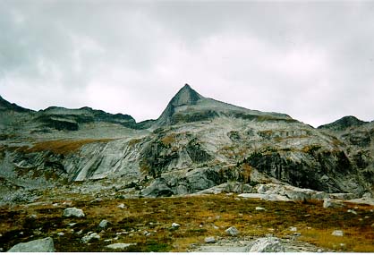 We watched a group of three men rope up beside Mount Gimli and belay down into the basin. They left their ropes attached so that they could climb back out after their hike. We met up with the men at the bottom and stopped to chat for awhile.
We walked around the glacier lakes in the basin and stopped to refill our water containers. We checked the time and decided we only had about 45 minutes to determine if we could climb out of the basin the way we wanted. If we were unable to leave the basin through our proposed route, we would be pushing it to return to our vehicle before dark via the route we descended.
We started up and when we arrived at our first snow patch, decided that it would be easier to skirt around the left of the snow. This put us on wet mud for awhile and in one place we had to ascend one at a time, because there was no way of preventing the rocks and mud from sliding down the hill. No one really wanted to take a chuck of rocks in the head. This was the only part of the hike I actually didn't like. The ground was not stable, and I didn't enjoy not knowing if my feet would stay where I placed them or start sliding downhill.
There was no way around the second snow patch. We also discovered that the snow patch was actually about 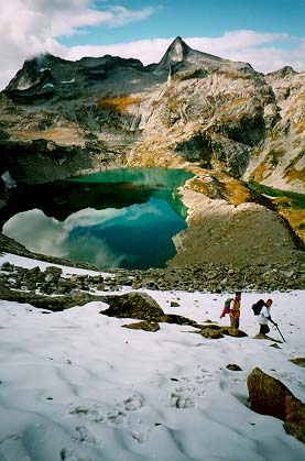 2cm of snow and then ice underneath. Climbing straight up the snow would not work. We skirted up the left side and stayed near the rocks, but remained on the snow. I dug my ice ax into the ice, took two steps, then re-secured the ice ax. Phil stayed behind me the whole time. He claimed he would stop me from falling all the way down to the rocks beneath us if I slipped. I doubted it, but it was nice to have someone chat me through the climb and give me a few pointers on using an ice ax, since that was my first time climbing with an ax.
We reached the top of the snow patch and I let out a sigh of relief. We stopped and had a snack and enjoyed the view surrounding us. John felt he needed to reach the top of a mountain peak, so he sprinted up the peak beside us. The rest of us talked about climbing the peak across the valley from us, before Lincoln reaches 60.
After a brief break, we headed back down. We weren't sure of what route to take, but we knew the general direction, so off we went. We thought we were at the back of a double peak named Wolf's Ears, but weren't sure until we made it around to the front. It was obvious where the name came from. Lincoln thought one of us should climb the ears for a photo opportunity, but there weren't any takers on that idea.
We ended up climbing to the base of the ears and then across to the next ridge. We weren't sure if there was a way down the ridge, but seeing as we weren't keen on the idea of going back the way we came, we figured we would find a route down. We took another break at the ridge and then found a small snow shoot about 3 feet wide, which we could climb down. It was another area that we had to step carefully so the people below wouldn't be hit with the rocks.
We crossed another field and headed towards the last ridge, the 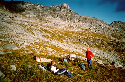 base of Mount Gimli. We took a break part way across and I could have stayed there longer, but we preferred to get back to the vehicle before dark.
I hurried down from the base of Mount Gimli because I really had to go to the bathroom, and the one problem with hiking with a group of guys in alpine area, is I could not always find a secluded area to take care of business. I was also unsure how far behind me the rest of the men were, Dave and I were out front, so I didn't feel comfortable stopping off the trail. Dave and I arrived back at the vehicle about ten minutes before the others. Long enough to undo my boots and stretch.
On the drive home, Phil had a hankering for some Polish sausage. So we stopped at a small convenience store and he bought a big Kobasa Sausage which he shared with the rest of us. We made it home, safe and sound. We spent eight hours total hiking, and about 4.5 hours driving. It made for a long, but enjoyable day.
Different views of Mount Gimli.