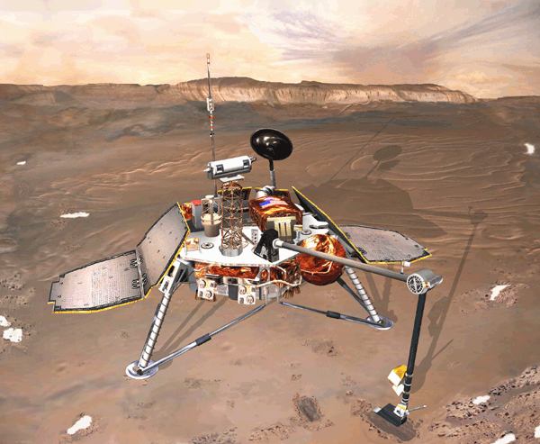
Description
The Mars
Surveyor '98 program is comprised of two spacecraft launched
separately, the
Mars Climate Orbiter (formerly the Mars Surveyor '98 Orbiter) and the Mars Polar
Lander (formerly the Mars Surveyor '98 Lander). The two missions were designed
to study the Martian weather, climate, and water and carbon dioxide budget, in
order to understand the reservoirs, behavior, and atmospheric role of volatiles
and to search for evidence of long-term and episodic climate changes. The last
telemetry from Mars Polar Lander was sent just prior to atmospheric entry on 3
December 1999. No further signals have been received from the lander, the cause
of this loss of communication is not known.
Scientific Objectives
The Mars Polar Lander was to touch down on the southern polar layered terrain,
between 73 S and 76 S, less than 1000 km from the south pole, near the edge of
the carbon dioxide ice cap in Mars' late southern spring. The terrain appears to
be composed of alternating layers of clean and dust-laden ice, and may represent
a long-term record of the climate, as well as an important volatile reservoir.
The mission had as its primary science objectives to: 1) record local
meteorological conditions near the martian south pole, including temperature,
pressure, humidity, wind, surface frost, ground ice evolution, ice fogs, haze,
and suspended dust, 2) analyze samples of the polar deposits for volatiles,
particularly water and carbon dioxide, 3) dig trenches and image the interior to
look for seasonal layers and analyze soil samples for water, ice, hydrates, and
other aqueously deposited minerals, 4) image the regional and immediate landing
site surroundings for evidence of climate changes and seasonal cycles, and 5)
obtain multi-spectral images of local regolith to determine soil types and
composition. These goals were to be accomplished using a number of
scientific instruments, including a Mars Volatiles and Climate Surveyor (MVACS)
instrument package which was comprised of a robotic arm and attached camera,
mast-mounted surface stereo imager and meteorology package, and a gas analyzer.
In addition, a Mars Descent Imager (MARDI) was planned to capture regional views
from parachute deployment at about 8 km altitude down to the landing. The
Russian Space Agency provided a laser ranger (LIDAR) package for the lander,
which would be used to measure dust and haze in the Martian atmosphere. A
miniature microphone was also be on board to record sounds on Mars. Attached to
the lander spacecraft were a pair of small probes, the Deep Space 2 Mars
Microprobes, which were to be deployed to fall and penetrate beneath the martian
surface when the spacecraft reached Mars.


