
What is the Southeast
Planning Area?
This area represents the greatest
corridor of growth in the city of Calgary. As it stands today, the
land is used for agricultural purposes. The study area is approximately
6 000 acres and is expected to become home to over 80 000 people by the
year 2023. Just to illustrate the magnitude of this development,
if it were to develop as a town of it's own, it would be the 3rd largest
municipality in Alberta.
The City
of Calgary's Planning Department has been recently developing an Employment
Centre Strategy to help manage the large growth that Calgary has been experiencing
and likely will experience in the future. They are working with the
land owners and developers in the area and are trying to come up with plans,
policies, and designs that respond to this Strategy.
What is this Design
Charrette all about?
 The
Planning Department approached the planning faculty at Environmental Design
to assist them in developing new ideas and concepts for this area.
Professors Sasha Tsenkova and Ken Johnson put together a project for the
first year planning class to (a) conduct background research on employment;
public facilities; housing; and policies and (b) create two design concepts
that acknowledge the Employment Centres Strategy and the background research
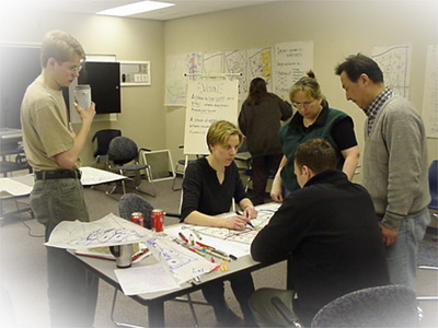
conducted. The resulting charrette was a 1 day, 11 hour event where
the class divided into two teams and arrived at their respective design
concepts. The
Planning Department approached the planning faculty at Environmental Design
to assist them in developing new ideas and concepts for this area.
Professors Sasha Tsenkova and Ken Johnson put together a project for the
first year planning class to (a) conduct background research on employment;
public facilities; housing; and policies and (b) create two design concepts
that acknowledge the Employment Centres Strategy and the background research
conducted. The resulting charrette was a 1 day, 11 hour event where
the class divided into two teams and arrived at their respective design
concepts. |
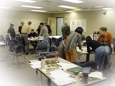
The Process
Starting out in the morning,
the groups were to establish their principles that would direct them 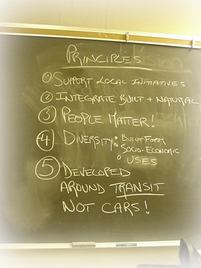 throughout
the day. Areas of consideration included: throughout
the day. Areas of consideration included:
- social environment
- natural environment
- economic factors
- built form
Once these were established
for each group, the most important items were chosen and agreed upon as
the guiding values for each group over the remainder of the day. |
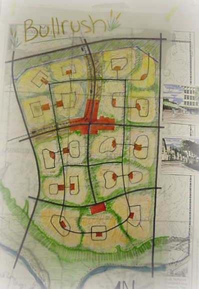
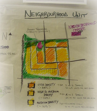
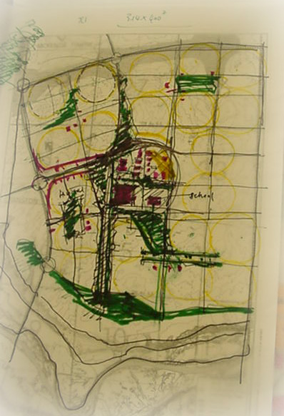 With
the conceptual framework in place, the groups then set out to create a
general spatial layout of the elements of the new community. Residential,
office, light industrial, retail, public facilities, and green space were
the major land uses that were considered. The layout of these uses
was put against the factors of transportation (the major highways of Deerfoot
Trail and Highway 22x are the west and north boundaries of the area), natural
boundaries (such as the Bow River), and compatible neighbouring uses. With
the conceptual framework in place, the groups then set out to create a
general spatial layout of the elements of the new community. Residential,
office, light industrial, retail, public facilities, and green space were
the major land uses that were considered. The layout of these uses
was put against the factors of transportation (the major highways of Deerfoot
Trail and Highway 22x are the west and north boundaries of the area), natural
boundaries (such as the Bow River), and compatible neighbouring uses. |
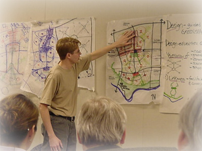 After
this stage, the group received comments from a panel that included planning
and architecture faculty members from Environmental Design, development
consultants, and practicing planners. As the ideas presented were
still very conceptual, the reviewers provided some insights on how to take
these concepts and create more tangible, detailed plans. After
this stage, the group received comments from a panel that included planning
and architecture faculty members from Environmental Design, development
consultants, and practicing planners. As the ideas presented were
still very conceptual, the reviewers provided some insights on how to take
these concepts and create more tangible, detailed plans. |
 After
a short lunch break, the groups were back at work. The teams began
to divide the work into different subject areas (transportation, land estimates,
land use mapping, etc.). The goal for the afternoon session was to
create a better defined idea of where we would put various land uses and
a logical reasoning into why we would take such measures. During
this session, group members further discussed ideas and used feeback from
the panel. Another key After
a short lunch break, the groups were back at work. The teams began
to divide the work into different subject areas (transportation, land estimates,
land use mapping, etc.). The goal for the afternoon session was to
create a better defined idea of where we would put various land uses and
a logical reasoning into why we would take such measures. During
this session, group members further discussed ideas and used feeback from
the panel. Another key 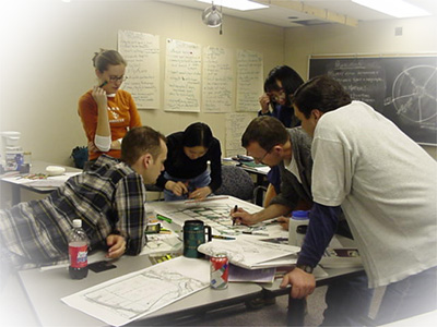 component
of this session was the background research that the students conducted
the in the previous weeks. One of the components of this assignment
was to arrive at various land estimate scenarios for a particular land
use. This greatly helped the students in establishing the appropriate
scales for such a massive planning area. component
of this session was the background research that the students conducted
the in the previous weeks. One of the components of this assignment
was to arrive at various land estimate scenarios for a particular land
use. This greatly helped the students in establishing the appropriate
scales for such a massive planning area. |
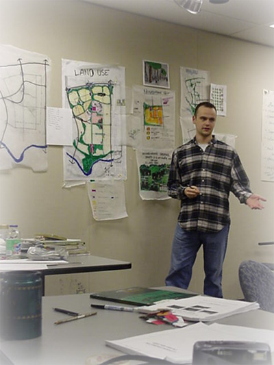
 The
final hour was frantic in both the charrette room and the planning studio.
A strict 5pm deadline was set by Professors Tsenkova and Johnson and all
presentation materials were to be completed by that time. Each design
consideration was to have a sound explanation and each land use was to
have a total acreage that it would require in each team's proposal. The
final hour was frantic in both the charrette room and the planning studio.
A strict 5pm deadline was set by Professors Tsenkova and Johnson and all
presentation materials were to be completed by that time. Each design
consideration was to have a sound explanation and each land use was to
have a total acreage that it would require in each team's proposal.
The deadline arrived and
so did the final review panel. Again, there were Environmental Design
faculty members, private sector consultants, and two planners with the
City of Calgary: Monica Pohlman and Kevin Frose - the two key figures in
the development of this area and the Employment Centres Strategy.
Both groups presented their concepts and tried to show why their ideas
made sense. The review panel were extremely positive about both concepts
and felt that given more time, the students would be able to create very
detailed and comprehensive plans and policies for the new area.
|
| Was the charrette a success?
 According
to everyone involved, it was. The students felt they gained a valuable
experience by working through a one-day pressure cooker. The faculty
gave a great deal of positive feedback. Included in this feedback
was the fact that our group really helped to open the City planner's eyes According
to everyone involved, it was. The students felt they gained a valuable
experience by working through a one-day pressure cooker. The faculty
gave a great deal of positive feedback. Included in this feedback
was the fact that our group really helped to open the City planner's eyes 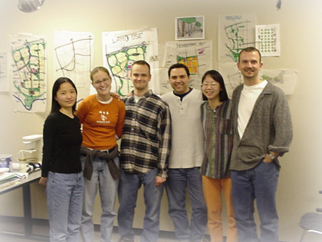 to
a number of posibilities, including location of land uses and increasing
employment projections for the area. to
a number of posibilities, including location of land uses and increasing
employment projections for the area.
|
Return to John's
Planning Projects Page