LEMONY FRESH
FALL
CLASSIC
ultimate frisbee
tournament
| |
LEMONY FRESH
FALL
CLASSIC
ultimate frisbee
tournament |
|
|
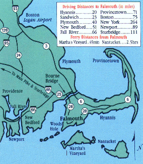
The tournament is moved from Norton Public Schools to our
backup site at the Trotting Park soccer fields in Falmouth,
Massachusetts.
Directions and stops for food & fuel are listed
below.
|
Route 3 south to Sagamore rotary. Proceed over Sagamore Bridge. Stay in right lane over bridge and take first exit. Go down hill to lights and take a left. Go 3.5 miles along Cape Cod Canal to Bourne rotary. Follow Bourne Bridge directions below. OR... route 3 south to Sagamore rotary. Rt.6 west (1st exit off rotary) 3.5 miles along Cape Cod Canal to Buzzards Bay rotary. Take route 25/28 exit (to right of tugboat), immediately bear right to route 28/Falmouth, go over Bourne Bridge. Follow Bourne Bridge directions below. OR...Route 24 south to I-495 (exit 14) to Route 25 to Bourne Bridge. Follow Bourne Bridge directions below. Check SmarTraveler at 617-374-1234, 1-800-44-anita, *1 cellular for bridge traffic updates to decide best route. Code for Cape Cod is 7*, code for route 3 is 3*, code for route 495 is 495*.
Route 95 north to route 195 east in Providence. Follow signs to route 25/Cape Cod, go over Bourne Bridge. Follow Bourne Bridge directions below.
Mass Pike (I-90) east to route 495 south (exit 11). Follow signs to route 25/Cape Cod, go over Bourne Bridge. Follow Bourne Bridge directions below.
I-84 east to I-90 (Mass Pike) to route 495 south (exit 11). Follow signs to route 25/Cape Cod, go over Bourne Bridge. Follow Bourne Bridge directions below.
Needed for all off-Cape directions above. From Bourne Bridge, take route 28 south (second exit) off the rotary on the Cape side. Go 11 miles on the divided highway (passing through the Otis rotary) and take the Brick Kiln Road exit in West Falmouth (first exit after Thos. Landers Rd. exit). Turn left at the end of the ramp. Go one mile, pass the Lutheran church on left. Continue to traffic lights and turn right onto Gifford Street. Go one mile. You'll pass Briarwood condos on left. Turn left where small white street sign says "Trotting Park Field." If you pass the Falmouth Little League, turn around.
On way to/from fields. Refer to directions above. More places to get food & drink in Falmouth are listed on the Cape Cod Flatball Fest Accomodation Page. Buzzards Bay rotary ---> From Bourne rotary, cross Bourne Bridge, stay in right lane & take first exit. Way Ho Chinese restaurant (open 'til 1am) 508-759-3886 Shaw's Fish & Lobster restaurant (open 'til 9:30pm) 508-759-1111 Exxon Mini-mart/Dunkin Donuts Bourne Bridge Liquors / Honeydew Donuts Bourne rotary ---> I-HOP pancake house (open 'til 10pm) Gulf station Tedeschi's convenience store-- just off rotary on Trowbridge Road by Best Western. Rt.28 south from Bourne rotary ---> From Bourne rotary, go 2 miles south on route 28 to Mobil Mini-mart on right. across is: Tedeschi's convenience store, Dunkin Donuts, McDonald's up hill on left past Tedeschi's is: A&P Supermarket, pharmacy, liquor/beer store Pizzas by Evan 508-759-9111 A couple miles further south on 28 is : Togo's Sandwiches/Dunkin Donuts. When heading north (off-Cape) on route 28, go to the Clay Pond Road turn-around, exit, and take an immediate right.
Falmouth Hospital 508-548-5300, Emergency Services: 508-457-3524, 911 Ter Heun Drive, Falmouth. Follow Gifford Street south to lights, make a right onto Jones Road. Go 1/2 mile to the lights at route 28 (Cape Cod Bagel). Go straight through lights. Hospital is 1/4 mile on the left.
From the fields, turn right onto Gifford Street and go about one mile to the lights. Turn left onto Brick Kiln Road and continue past route 28 to route 28A (West Falmouth Highway) (~2.75 miles). Turn right and go less than half a mile to Chapoquoit Road on the left (don't pass Fire Station). Follow down to Chapoquoit Beach. You need a resident sticker to use the lot before 4:00 or 5:00 pm, but you may be able to get away with parking illegally on the street for a short time. After 4:00 pm or so, parking is free. If you're not playing and want to spend more time, Old Silver Beach is very popular and the next closest to the fields. There are many more Falmouth beaches.
FROM FALMOUTH CENTER/WOODS HOLE: Take route 28 north to Brick Kiln Road exit. Take a right (head east). Go one mile, pass the Lutheran church on left. Continue to traffic lights and turn right onto Gifford Street. Go one mile. You'll pass Briarwood condos on left. Turn left where small white street sign says "Trotting Park Field." If you pass the Falmouth Little League, turn around. OR... Take Gifford street off Main Street in Falmouth (it's opposite the fire station & quicki-lube). Head north for about 2 miles. Look for small white street sign that says "Trotting Park Field" on right immediately after large little league sign. Turn in this road to Trotting Park fields. FROM EAST FALMOUTH/MASHPEE: From the Mashpee rotary, take route 28 toward Falmouth. After 3-4 miles, there will be a stop light on the corner of Meetinghouse Way in East Falmouth. Go about .75 miles (pass Fire Station and Library on right) and turn right onto Ox-Bow (sign says 'to Vineyard Ferry'). Bear right onto Brick Kiln Road after 1/4 mile. Go about 1.5 miles to lights at Gifford Street. Turn left at lights. Go one mile. You'll pass Briarwood condos on left. Turn left where white street sign says "Trotting Park Field." If you pass the Falmouth Little League, turn around. FROM THE MID & LOWER CAPE: (There are two routes from the Mashpee rotary; I included them both. The rt.28 route is slightly slower, but has more stops for food, etc.) Take rt.6 to exit 5. Left off the ramp onto route 149. Take route 149 south about 3.5 mi. to its end at route 28. Take a right onto route 28 and follow about 4.5 miles to the Mashpee rotary. It's on route 28 at Mashpee Commons. <> From the Mashpee rotary, take route 28 toward Falmouth. After 3-4 miles, there will be a stop light on the corner of Meetinghouse Way in East Falmouth. Go about .75 miles (pass Fire Station and Library on right) and turn right onto Ox-Bow (sign says 'to Vineyard Ferry'). Bear right onto Brick Kiln Road. Go about 1.5 miles to lights at Gifford Street. Turn left at lights. Go one mile. You'll pass Briarwood condos on left. Turn left where white street sign says "Trotting Park Field." If you pass the Falmouth Little League, turn around. OR... <> From the Mashpee rotary, take route 151 west. Go through lights at Mashpee Commons several miles to lights at Sandwich Road. Get in left turn lane and take a left at the lights. There is a gas station and mini-mart here. Go about 4 miles to lights at Brick Kiln and Sandwich Roads. Turn right onto Brick Kiln. Go about one mile to lights at Gifford Street. Turn left at lights. Go one mile. You'll pass Briarwood condos on left. Turn left where white street sign says "Trotting Park Field." If you pass the Falmouth Little League, turn around. |