 |
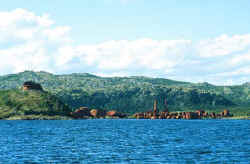
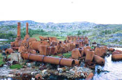
| Abandoned Whaling Station, Hawke Harbour, Labrador |
 |
As this is intended to be read by other cruisers, some readers may enjoy things technical when it come to boats. In view of that, a little bit about Tamara is in order. "Tamara" was built of steel in Sweden in 1989. Designed by Rolf Modigh, she is designated his type Langedrag 441. 44’ overall, with a draft of 6.5’, she displaces 15 tons. A center cockpit ketch, she very strongly resembles the Halberg Rassy 46’, including her windshield and interior, but of steel. She is heavily insulated with foam, well heated with a diesel stove, and more comfort than the two of us really need. Her main engine is a 90 hp.Volvo TMD-30 diesel, and auxiliary generator a 6kw Deutz. She tanks 200 gallons of water and, in our Labrador configuration, 265 gallons of fuel, giving her a very extended range under power.
What began life as a single-berth stateroom to the port side of the engine room has now been transformed to my work-shop, the bunk becoming a very fine work bench by the simple expedient of leaving the mattress in the rented storage unit, bolting on a vise, and stuffing all the lockers with tools and spares. She easily stows provisions for six months for the two of us. Her aluminum dodger affords a sheltered inside helm station with autopilot, radar and radio, and is heated from below if desired. And of course she has most the modern electronic gizmos which serve mostly to reconfirm for me how truly skilled (as well as occasionally lucky) people like Donald MacMillan really were.
Because of our interest in higher latitudes and my experience as a fisherman in cold climates, Tamara is provided with an offshore life raft with SOLAS A pack, commercial fishing boat style immersion suits, SSB radio and EPIRB, as well as an abandon ship bag intended for use should we find ourselves driven ashore. This includes tent, sleeping bags, cold weather boots and clothing, stove and food, as well as a shotgun. During my career fishing I was twice forced to abandon ship, and I don’t expect anything less of a yacht when it comes to safety equipment and training. She is as well found for the purpose as we can make her.
The Labrador coast is not for everyone of course, but for the adventurous cruiser with a reasonable degree of experience and a well-found boat, it should be given a high ranking on one’s life list. For American boats, Maine is obviously the best jump off point, and Nova Scotia and Newfoundland offer bonus cruising along the way. However, the preparation and planning for a Labrador cruise require some extra attention.
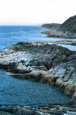 |
| South Labrador Coast |
 |
| Seaplane Cove, Northern Labrador |
Obviously the boat must be well-found to begin with, but other considerations must also be taken into account. All mechanical systems must be in first-rate condition, as technical assistance is a very long distance away. Someone on board must have a fair degree of mechanical aptitude and experience, and spare parts will of course have to consist of far more than would be aboard for the general ICW Snow Bird transit. The engine should be powerful, and the propeller sized and pitched for extended running under power. Fuel capacity must also be considerable, as much of the cruise will by necessity be done under power.
Ground tackle should be twice a heavy as that recommended in all the mail order catalogs, as gales are frequent, anchorages often deep, and the bottom often foul with rocks and kelp. At least the primary rode must be all heavy chain, and several anchors, including alternate types, should be carried.
Radar is essential, as well as experience in its proper use. A portable depth sounder, for use in scouting with the dingy, is very useful. All the customary electronic aids aboard modern cruising boats become even more valuable on this remote coast. Although we generally use a PC based electronic charting system, only large-scale "planning charts" have yet been digitalized for Labrador. However we use our system as a chart plotter, taking way-points from the paper chart and plotting them on the screen. This method reduces fatigue generated mistakes, and makes short-handing much more practical, as it is quite reassuring to be able to follow a pre-prepared plot instead of taking constant fixes. There is considerable error in the "horizontal datum" on many charts, particularly farther north. For this reason NDI has not completed digitalizing these charts, as the discrepancy is not a constant, and a simple conversion will not remedy the error. Be aware of the error when using modern GPS. Traditional range and bearing piloting skills are of high value, and radar will help with precise range measurements.
A single side band HF radio, weather-fax, or at least a short wave receiver capable of receiving the relevant weather forecasts is essential. VHF repeater systems, operated by the Canadian Coast Guard, provide excellent communication, telephone patch, and weather broadcasts, but coverage extends only a few miles beyond Hopedale (55° 27’N). An up to date copy of the Canadian Coast Guard’s Radio Aids to Navigation should be consulted for times and frequencies of weather forecast voice or fax broadcasts.
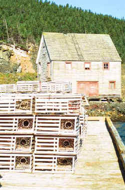
Stores stocked with the very basics, as well as fuel, are available in Cartwright, Makkovik, Hopedale, and Nain. We prefer Makkovik, due to its strategic location, exceptionally hospitable people, and two good stores. However, fresh produce and meats are not to be generally expected, although timing of supply ships and flights might put you in luck.
August 9th. Makkovik. We are now back to our preferred supply point where we will take fuel, water and what fresh produce may be available. Then we will continue south, with stops at a couple of abandoned whaling stations, a brief decompression in Battle Harbor, and then make for the east coast of Newfoundland.
Friday, August 24, 2001. Moreton’s Harbour, Notre Dame Bay, northeast coast of Newfoundland. After several sunny days, rain and a 40K northerly gale. 3006 miles logged since departing Portland.
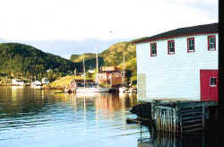 |
| Moreton’s Harbour, Newfoundland |
I know that it must seem as though it’s terribly stormy every time I sit down to write one of these dispatches, and I suppose that is in fact the case. As a matter of fact, the weather has not been consistently horrible, nor is there a causal relationship between my attempts to write and storms. It’s simply that we practice the school of seamanship that dictates that you "go when the going is good", so the only time that I am able to sit down and peck away at the computer is when it’s too miserable to do much else.
Moreton’s Harbour is a small, well-sheltered harbor that was once, as was most of Newfoundland, a cod fishing "outport" and home- port to Labrador bound schooners. When I say well sheltered, I should add sheltered from all winds but northerlies. At noon today the moderate southerly veered almost instantaneously to a gale force northerly. Tamara is presently lying behind a very small point of rocks that affords meager protection from the sea building from the north. She is made fast to a number of old iron ring bolts secured to the rocks, and I’ve been nervously tending the cat’s cradle of lines that hold her in the lee of a small wharf and picturesque fishing gear shed.
 |
| Moreton’s Harbour, Newfoundland |
The gear shed, ring bolts, and two small floats combine to form what is listed in the 2001 Travel Guide to Newfoundland and Labrador as the Moreton’s Harbour Marina. A beautiful spot, complete with hot tub, showers and laundry, but a snug fit for a fifteen ton, forty-four footer. Things were perfectly cozy until the wind veered, and ratcheted up several notches. However I’ve been reassured by a delightful octogenarian, Gerry Knight, that those ring bolts should be good for about seventy knots.
The Knight family has been here for a very long time. As chandlers and outfitters for Labrador bound schooners, merchants, and schooner owners themselves, the Knights have seen these very bolts tested a time or two before, by more tonnage than Tamara’s. I’ll have to take his word, as there is no getting clear of here now without being set up on the other rocks that form the little marina. The Knight family offers this small haven mostly because they seem to genuinely enjoy the company of occasional cruisers who stumble upon the place. It couldn’t be for the money, as the fee is only $10.00 Canadian, by far the best bargain of our cruise, and typical of Newfoundland hospitality. Last evening the Knights were enjoying a family reunion of sorts, with family and friends visiting from across Canada. Nancy and I were included as though our names were also Knight, and we did our best to entertain with stories of Labrador.
Before arriving at Moreton’s Harbour we had called in at St. Anthony, a superb natural harbor on the northern tip of Newfoundland. It was in St. Anthony in 1893 that the famous Sir Wilfred Grenfell headquartered the medical mission that would serve northern Newfoundland and all of Labrador. First building the hospital in Battle Harbour in the previous year, Grenfell situated his base of operations in St.Anthony not only because of the need for medical care in that part of Newfoundland, but also because it was the perfect harbor in which to home port the succession of hospital ships that he would use to dispense medical care to remote locations to the north. While his work as a physician, organizer and found raiser are legendary, my admiration for Grenfell is because of his skill as a master mariner.