 |
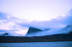
| Williams Harbour, Northern Labrador |
Thursday, July 26, 2001. Williams Harbour, near the northern tip of Labrador. 60° 00’N, 64° 15’W. Northwest Gale 40K, gusting higher, sleet, air temperature 37° F, water temperature the same. Dense fog. 1906 miles logged since departing Portland.
Torngat; to the Labrador Inuit, the Abode of the Evil Spirits. For nearly a week we have been anchored here in Williams Harbor, while an unending succession of gales has swept through Hudson Straits and around Cape Chidley just to our north. The Spirits have not yet granted their imprimatur to our passage, and we have not disregarded their message. The shelter and holding ground here have been most welcome, although the fog has rather inhibited the view. When we entered this harbor, on the 21st, the clear weather and gentle easterly belied what was soon to come, but at least afforded an excellent view of the fjord and the surrounding mountains. Since then we have been able to see little of the Abode, but we have certainly been able to hear the Spirits wail.
Of the modern contraptions that we have aboard for entertainment and reference, a complete collection of National Geographic, since its inception, all on computer CDs, tops the list. During our stay here I’ve had plenty of time to read, and a few articles by or about Donald MacMillan and the schooner Bowdoin have been of great interest to me. For those readers interested, see the November 1923, March 1926, and particularly the October 1951 issues.
Miriam MacMillan, author of the 1951 article and an earlier book, Green Seas and White Ice, which we also have aboard, describes this region as, "uncharted inlets along the icy, ledge strewn coast of Labrador." She writes that Cape Chidley, just to the north, is referred to as "The Cape Horn of the North". While I had not heard that description of Cape Chidley before, I will not take issue with the comparison. Eight-knot currents from Hudson Straits, wind and heavy fog make it easy to believe this region is controlled by Torngak, the Evil Spirit of the North. MacMillan continues, "If the next run is treacherous and we have far to go before making harbor, we sit by, waiting patiently." We will do the same.
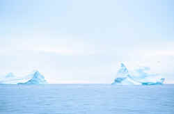 |
| Icebergs off Hebron, Labrador |
The last one hundred miles we have followed the Bowdoin’s inshore route, around Cape White Handkerchief, inshore of Big White Bearskin Island, anchoring in Sea Plane Cove, rounding Cape Kakkiviak and Black Rock Point. The Torngat Mountain Range, among the highest in eastern North America, sends magnificent fjords to the sea. Although we have worked close inshore for much of this passage, that run was indeed treacherous. Ledges, fog, rocks, (charted and not) and exceptionally severe tide-rips ring the passage. The "ledge strewn coast" even precludes one from calling it quits and heading back out for the open Labrador Sea. Once on this inshore route, you’re committed to stay the course until completing the passage. Charts drawn well before my birth bear newly affixed warning stickers proclaiming in red letters that the "horizontal datum" has not been reconciled with modern GPS or Loran systems. One’s piloting skills must remain constantly sharp. The prudent mariner is cautioned to expect errors of up to one half mile. We resolved that our return would be offshore for this part of the voyage, as our supplies of adrenaline surly must know a limit.
Whether or not we will be able to continue farther north, or will have to turn south soon, will depend upon the duration of these gales. Time is always short enough during summers at this latitude, and we have expended much of ours here in Williams Harbor. It is not our intent to winter over, and we still wish to return to Portland for this winter via the east coast of Newfoundland, thereby completing a circumnavigation on this voyage. Time is now a matter of consideration as the Equinox can be counted on to bring sustained gales.
Friday July 27th dawns clear and sunny, revealing a heavy blanket of fresh snow on all of the nearby mountain peaks. But there is little time to enjoy the newly revealed beauty of our surroundings, as the passing of the front that had obscured our view is accompanied by a 40K westerly wind blowing down Tellialuk Fjord, directly into the entrance to Williams Harbor. Time has come for us to depart, as we are no longer offered sanctuary here.
We work north, past a number of fjords trending to the west, and are blasted by katabatic winds each time we transit an inlet. But no sea is up, as the wind is offshore. We pass Martin Bay, now known to have been the site of a secret German weather station during World War II, Ikkudliayuk Fjord, Clark Harbor, and out through a narrow entrance between rocks, breakers and Amity Island into which sets a huge easterly swell remaining from the week of northeasterly gales. Although the passage drains just about the last of our adrenaline reserves, the transit takes us to the open sea; for the time being at least. In ten miles or so we must re-enter MacGregor Straits between the Cape Chidley Islands and Killinek Island, off the northern tip of Labrador.
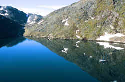 |
| O’Brien Harbour, Northern Labrador |
Having to pass by Bowdoin Harbour, due to the heavy swell breaking completely across its ninety- meter wide entrance, we must make the entrance into the straits against the tremendously powerful tidal current in order to enter O’Brien Harbour. Using every bit of Tamara’s ninety horsepower, and employing the river-runner’s trick of staying frightfully close to the cliffs lining the edge of the strait in order to take advantage of the slower flow resulting from friction between water and rocks, we finally enter the inlet. At the head of O’Brien Harbor is a small amphitheatre, ringed by 1800 foot peaks rising directly from the sea, very well sheltered from the sea, but a place sure to experience severe williwaws when the wind gets up. Just like blowing across the top of a pop bottle, old Torngak is bound to give us one last concert before we depart his Abode. Anchor watches with the engine warm and ready are the routine, as rock walls surround only a few meters distant. The powerful williwaws continuously spin us about our anchors. At times it seems as though we are being knocked down, under bare poles, on anchor, but then the wind sheers off to yet another direction.
As if to reward our tenacity, the next day brings calm and sun, allowing us ashore to hike, photograph, and fill our water tanks from the near-by cascade. But the week lost to the continuous gales, and a slight but persistent leak in the engine’s fuel injection pump force a decision. We will have to forgo crossing Hudson Straits for Frobisher Bay. Instead we will round Cape Chidley for the Button Islands, then to Hudson Straits and finally east for the Labrador Sea. While we have aboard nearly a half-ton of spare parts and tools of all descriptions in our fairly complete workshop, the precision injector pump is not serviceable aboard. The time has come to begin to make our way south. We will do so in a series of longer offshore passages that are more conducive to sailing and which afford greater sea room, as we wish to stay well away from the "numerous uncharted rocks and ledges". 60° 30.11’North, just short of 2000 miles logged since departing Portland, would have to do for this season’s Farthest North. Now we would head 225 miles south for Cape Mugford.