As to this season’s voyage, so far we are essentially on a "delivery trip". That is to say that since departing Portland, Maine, where we wintered aboard our forty-four foot steel ketch Tamara, our mission has been to get into a good position to press north as fast as we are able when the ice allows. The ice persists much longer on the Labrador/Baffin side of the Labrador Sea than the Greenland side, due to the effects of the Labrador Current. For this reason the Yankee whaling fleet historically used the "North About" route, sailing up the coast of Greenland past Disko Sound, before turning west for Lancaster Sound. Our objective is the west side of the Labrador Sea, however, so we will proceed as the ice and weather permit. The consummate master of the Labrador route, of course, was Donald MacMillan with the Bowdoin, and we share his philosophy that one simply goes when the going is good.
Our crossing of the Gulf of Maine was uneventful. Decent southerly breezes for half of the first day gave us fair sailing, but the winds then subsided to very light airs. This required us to motor sail most of the 240 miles to Shelburne, Nova Scotia, encountering very little traffic, with only a few stern trawlers visible on the horizon.
Clearing in at Shelburne, however, proved to be much more cumbersome than the customary phone call to CANPASS. Our 0300 call was automatically routed to the Halifax Marine Unit of Canada Customs, and a formal entry inspection scheduled for 1400 later that day. Two very professional and scrupulously courteous customs agents arrived precisely on schedule that afternoon from Halifax. We were informed that new policy directive from Ottawa required a more formal entry procedure for yachts, due to increased concern about illicit drug traffic into Canada. The inspection was not a great imposition, and focused mostly on our log and charts, documents and so on, but it did require that we submit ourselves to the more formal procedure.
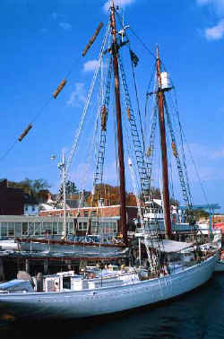 |
| s/v Bowdoin |
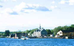 |
| Shelburne, Nova Scotia |
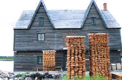 |
| Shelburne Cooperage Shop |
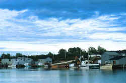 |
| Dingwall, Cape Breton, Nova Scotia |
 |
| Norris Point, Newfoundland |
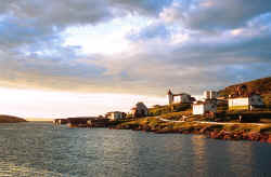 |
| Battle Harbour, Labrador |
From Shelburne we made our way up the Nova Scotia coast in a succession of day trips, anchoring along the magnificent dunes of Kejimkujk National Park, in Port Mouton, working through fairly thick fog up the La Have River to Riverport, bypassing Lunenburg, Mahone Bay and Halifax as we have been there before, anchoring in Jeddore and Little Liscomb harbors, transiting St. Peter’s Canal into Bras D’Or lakes, and finally to Saint Ann’s Bay, Cape Breton. St. Ann’s is the home of veteran Labrador cruisers, Chris and Anne Laws, whom we had met on our prior cruise. After a fine extended visit, with far too much to eat, we finally left their gracious hospitality, bound for Newfoundland. A few hours late, however, another storm warning altered our plans, so we put into Dingwall harbor, home of an extensive lobster fleet. Our wait would be accompanied by additional gastronomic excess, including two huge examples of the local produce.
July 1, 2001, Canada Day. Battle Harbor, Labrador. 52° 16’N, 55° 35’W. Southeast Gale, heavy rain, air temperature 41° F, water temperature 38ºF, 1119 miles logged since departing Portland.
From Dingwall, Nova Scotia we ran 185 miles directly to Corner Brook, Newfoundland. Our intent had been to make for Port au Choix, another hundred miles up the coast, but yet another northwest gale made the security of the Allen Cove Marina and the hospitality of the Bay Of Islands Yacht Club more attractive. The second largest city in Newfoundland, Corner Brook is situated at the head of the Bay of Islands. First surveyed and charted by the redoubtable Capt. James Cook in the 1760’s, the bay is, as its name implies, a magnificent bay studded with islands. The good Captain must have grown short of creative place names, however, as I know of at least two other bays to which he applied that moniker, one in New Zealand, and yet another in Prince William Sound, Alaska. Nancy has now transited all three, so I may be compelled to try for the hat trick as well.
Port au Choix, as it translates from the French, is the port of choice. The finest natural harbor on the west coast of Newfoundland, it has been the site of human habitation for 5,500 years. From the first Maritime Archaic Indians, the Groswater Palaeoeskimos, the Dorset Palaeoeskimos, to Basque, French, and English whalers and fishermen, Port au Choix has been the source of shelter from the storms of the Straits of Belle Isle and marine resources for longer than just about any other place in the New World. A series of archaeological digs, and a very fine collection of artifacts are on display at the National Historic Site visitor’s center.
Fifty miles or so up the Newfoundland coast is a very small harbor in a place called Black Duck. A year ago, on our return from Labrador, we sought shelter from the late season gales of the Straits of Belle Isle in Black Duck harbor. As soon as we made fast to the wharf, two elderly gentlemen made their way down the ramp, and asked to come aboard. In their eighties, these men had known each other their entire lives. They were middle aged when the first road connected their village to the rest of the island, and seldom had they ventured far from home except to fish "the Labrador". With the collapse of the Cod fishery in Newfoundland, fishing for the specie that had defined life on "The Rock" for five hundred years had now been restricted to but three days per season for personal use only. Notwithstanding their advanced age, these men were excitedly preparing to spend all of the next day together in a dory, jigging for cod, in the Straits of Belle Isle.
Our visitors’ interest in Tamara was genuine, as well as extensive, as both men vividly recalled the time when schooners sailed north each season for the Cod. To them, we were very special, having just returned from Labrador aboard a sailing vessel. What I found touching was their deep friendship and complete reliance on one another. One gentleman was tall and hardy, with strong, work-hardened hands, but he could see and hear only very poorly. The other was much smaller, hunched over, able to get around only with great difficulty, but his eyes and ears were just fine, thank you! So this symbiotic pair worked as a team, with the sighted one doing the navigation, with the stronger man assisting his friend in getting around. Their respect for what we had done with Tamara was very gratifying, as these men knew where we had been and what it had required of us to do so. That is the best sort of professional recognition.
At 1800 NDT, the instant that the gale backed from the northwest to the southwest, we picked up the two anchors that had secured us to Port au Choix’s firm mud bottom, and thrashed our way out into the Straits of Belle Isle, gaining enough sea room to enable us put the gale on our stern, and make our way north. Twenty-two hours later we arrived here in Battle Harbour.