 |
| Kiglapait Mountains |
Labrador - Part 2
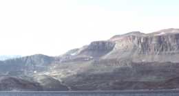
The next day, as we departed Port Manvers, we got our first glimpse of the spectacular Kiglapait Mountains of the Mugford area. Cape Mugford and the surrounding region is a layered geologic formation similar in appearance to the Southwest US, and its striking profile served as the approach beacon for mission ships for more than 150 years. Operating a succession of ships all named “Harmony”, the Moravians never lost a ship supplying this challenging area. We anchored in the bay at Okak, another abandoned Moravian mission site with only a few foundations and a cemetery remaining. Haven and his fellow missionaries built Okak, the second Moravian mission, in 1776, with the structures having been pre-fabricated at Nain during the preceding winter. Its population was tragically devastated by the influenza epidemic of 1918-19 that killed one-third of Inuit along the coast. We also encountered a native family spending a month close by at their fish camp. They had come to Okak to pick bake apples, a small orange berry, common along the Labrador coast, fish, and prepare for caribou season.
 |
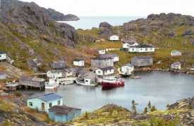
| Mugford, Labrador |
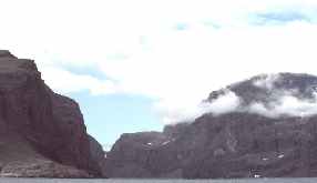
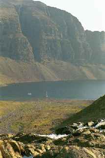
August 10th and we’ve had 60-70° sunny weather the last couple of weeks. We anchored the next night outside the inner pool at Anchorstock Bight in the Mugford area. We thought how neat it would be to get inside, but the entrance was narrow and rocky and there is no chart detail, and it certainly appeared impassable. In any event the season was progressing and we were on the fast track north. We would have to leave exploring the area for the return trip. That night we saw the Northern Lights, a first for Nancy. The next day we transited Mugford Tickle, preceded along the coast to the fjord of Hebron. We anchored in the bay offshore the abandoned Moravian mission at Hebron.
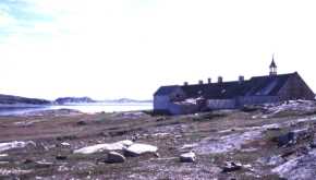 |
| Hebron, Labrador |
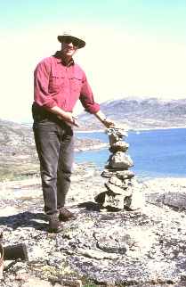 |
| Mark at Hebron |
Hebron was established by the Moravian Church in 1829. The church abandoned it in the late 1950’s, and the Canadian government refused to provide support due to the high cost and the difficulty of logistics. Many of the structures remain, including the original church and school building, constructed in 1830. The only sign of life is the local caribou herd that has taken over the site. As we toured the site, we smugly felt that we were now well off the usual course, well beyond range of the non-accidental tourist, of being on the edge or near it. That is until a helicopter appeared and landed within a 100 ft of us. Aboard were a Canadian film crew and 2 native elders who were there to shoot a documentary film on the old mission. They were as surprised to see us as we were them. Hebron also seems to be directly under the path of polar flights to and from Europe, as high above us were the contrails of jetliners. Despite the fact that we were 200 miles from the nearest village, on a remote and difficult coast, we are reminded of how small the world really is.
August 12th. We cruise to our northernmost destination, Saglek fjord. Cape Uviak heads the entrance. The cape is a prominent, precipitous headland, rising 450 meters directly from the sea. Atop the Cape stands a new military radar dome, and below several buildings and an airstrip stand to the west. This area would be our personal “Furthest North” this cruise, as the season was now well advanced. The Canadian Sailing Directions indicate that the bay “can usually be entered with ice breaker assistance by July 1”, and that “ice closes Saglek Bay to navigation by October 1”. With only another 115 miles to the very tip of Labrador, Cape Chidley, it was with regret that we made the decision to turn south, but it was time. It was not our intent to spend the winter, and we did not care to have to request icebreaker assistance. Fuel remaining, though adequate, would leave little margin of safety, and while we had stores for at least four more months, we did not care to press our luck with the weather that we knew would come with the approach of the Equinox.
“Tamara’s” safety and survival equipment is extensive for a yacht of her type, but in keeping with commercial boat standards. Her Viking life raft carries a SOLAS A pack, water-maker, and EPIRB, and is supplemented with two abandon ship bags holding supplemental rations, water, and equipment. In addition she carries Mustang full immersion survival suits, rather than the cover-all deck suits commonly found on high latitude bound yachts. Finally, against the possibility of a forced stay ashore, “Tamara” carries a large watertight bag stuffed with a tent, sleeping bags, stove and fuel, rations, shot gun and ammunition, as well as winter clothing and boots. Mark has twice abandoned ship to life rafts in Alaska, and does not intend to do so again without T.V., microwave and his Lazy Boy recliner. Every attempt has been made to assure that “Tamara” has been equipped for any eventuality, and his twenty-one seasons in high latitude waters have been brought to her fitting out.
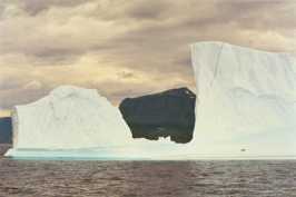 |
| Icebergs outside Anchorstock Bight |
|
|
| Tamara in Anchorstock Bight |
We would begin the long journey south the next day. A gale was forecast for the next evening and the day after so we headed for Jerusalem Harbor, a well-protected harbor recommended by the Belvedere, just north of Hebron. We put all 3 anchors out and waited out the storm. Two days later during our scheduled 0800 radio schedule with the Belvedere, another boat broke in after hearing that we would be back in the Mugford area that night. Chris and Anne Laws on Groais II were going into the inner pool at Anchorstock Bight that we had seen on our way north. We arranged to meet them that evening and try to follow them into the pool. That afternoon, as we made the approach to Anchorstock Bight, we encountered our largest iceberg. Two large seals, basking on the ice, appear only as specks in our photos of the huge berg. Even with a long lens on the camera, prudence got the best of us, and we refrained from approaching too closely, not only for the privacy of the seals, but as the unstable berg would have easily capsized “Tamara” had it rolled.
We met Chris and Anne and, with Chris in the spreaders of their boat and Anne at the helm, we followed them into the pool. Groais II made it into the pool with apparent ease, but just as we passed the large rock in the middle of the entrance we hit bottom. “Tamara” lurched, the sound of her steel hull hitting rock quite loud, and the look on Mark’s face was one of shock. But that’s why he always insisted on a steel yacht, as years of Alaskan experience and a strong desire to push into remote places taught that lesson well. An underwater inspection the next day about froze his face and ears, but convinced him that there was no real damage, only to paint and pride.
 |
| Chris & Anne Laws and Mark |
Chris and Anne had us over for dinner that evening to enjoy their delicious caribou stew. Knowing that it was not caribou season, we were inquisitive as to the source of the succulent fresh meat. Apparently Chris had been on a hike the day before and had come onto a recently deceased caribou that had been mauled by a polar bear, but being fleet of foot as is characteristic of its species, had escaped. He decided that it would be a waste to leave the meat, so butchered the carcass and returned to the boat with fifty pounds of meat wrapped in his T-shirt! After an entertaining evening on Groais II we decided to stay, enjoy the company and explore the area. The next day we hiked with Chris and Anne up to the snowfields so Chris could get photos/movies of himself telemark skiing in Labrador! Who are these people? Chris is from England, a dentist and Anne is Canadian and a doctor. They live in St. Ann’s, Cape Breton and have been cruising Labrador for 20 years. In addition, they run a cross-country ski resort on their property during the winter. We left the following day and managed to just tap the rock on our way out.
We had planned on visiting the labradorite quarry outside of Nain on our return, but Nick, skipper of “Belvedere” had told us of John Hayes Harbor where labradorite could be picked up along the beaches. Two days after leaving Anchorstock Bight we entered John Hayes Harbor in extraordinarily thick fog with the aid of our radar. The entrance seems only a few meters wide, but with Mark navigating by radar and Nancy on deck trying to see, we inched our way into the entrance. Once inside and anchored, the fog began to lift. The next morning we took the dinghy to the beach, and just as Nick promised, we found crystals of the iridescent blue mineral at the edge of the water.
 |
| Punchbowl, Labrador |
 |
| Triangle Harbor |
Our trip south included stops again in Hopedale to visit the Moravian Mission, Makkovik for fuel, Indian Harbor, and Cartwright to return the charts we borrowed from Randy. We had decided to take the inside passage south of Cartwright that we had missed on the way north. The Punchbowl is another abandoned codfish out port, with, once again, an extremely narrow entrance into the harbor. This one however was buoyed. A local entrepreneur has taken over the fish plant and is collecting iceberg ice for sale. This area has numerous abandoned out-ports, a sign of what once was.
Our southbound route took us through Frenchmen’s Run, a spectacular thirty mile long inside passage. The destination for the night was Triangle Harbor, which would have the narrowest yet of our entrances into an out-port harbor. A substantial ocean surge just outside the rocky entrance made us appreciative of the pilot service provided by two fishermen as they led us into the harbor with their dory. There is currently a thriving local crab fishery, and this small village is alive once again, even though no cod is drying on flakes onshore.
The next day we were bound once again for Battle Harbor. We were met upon arrival by Mike and invited to dinner that evening. Also in port for the evening were a couple from England, Bill and Jane McLaren, aboard “Vagrant of Clyde”, a 40 ft. cutter they had sailed from Scotland via Iceland and Greenland. They were to leave the boat in St. John’s, Newfoundland and return to Scotland then return this spring to continue their cruise. Their novel route includes transiting the St. Lawrence River to the Great Lakes, then shipping “Vagrant” to the Pacific North West. After two nights in Battle Harbor, we continued down the Labrador coast to Red Bay. In the 1970’s, archaeologists discovered and excavated a 16th-century Basque whaling station, likely the earliest industrial complex in the New World. From small fishing boats called “chalupas” (“Drop the chalupa lady” taco resembles this watercraft), Basque sailors hunted whales in the Straits of Belle Isle and tried out whale oil to fuel the lamps of 16th century Europe.
A northwest storm was forecast for the evening, and the local government dock was not the spot to be. So we anchored inside the bay with all chain and anchors out. And waited. The forecast kept predicting gale force winds, but 24 hours passed and nothing materialized. It was now September 1st, so we knew that the weather would likely become less favorable as the Equinox grew closer, and that northwest storms would generally be followed by a strong southwesterly. We had no strong desire to buck a stiff southwest sea, so we waited even more. By evening the barometer was down, and the winds finally struck suddenly. Averaging 40 knots, with gusts to 55 knots, the sound of the wind precluded any rest that night.
By morning, our two GPS receivers and radar indicated that we had dragged anchor only slightly, but unfortunately into shallower water. The winds had subsided to about 25 knots, so we picked up anchors and headed for the dock, now a better place to be as the wind direction had shifted. Being on the dock also let us get ashore and tour the Basque whaling museum.