 |
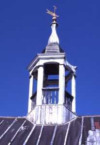
| Battle Harbor |
Labrador - Part 1
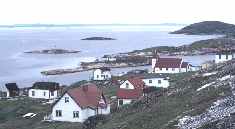
July 26th left for our first landing in Labrador, Battle Harbor, under sunny skies that soon became shrouded in fog. The fog lifted just as we made the approach to Battle Harbor, an intact traditional 18th century salt fish out-port, the first Grenfell Mission hospital in Labrador, and Marconi station where Peary wired details of his claim of the North Pole in 1909 and site of his famous press conference. Due to the interest of a few local area residents, Battle Harbor has been beautifully restored and is now a National Historic District. We had no idea that this jewel existed. The curator, guide, and manager of the area, Mike Earle, was a great host and spent quite a bit of time showing us the area and the details of restoration. There’s a dock to tie up to, showers and laundry, store, accommodations and meals.
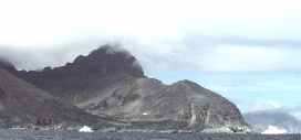 |
| Icebergs along the Labrador coast |
The following day, July 27th, we departed in beautiful weather but after motoring north for an hour we were very quickly engulfed in fog. We began to see icebergs on a regular basis now, some of extraordinary proportions, grounded along the rocky coast. This section of the Labrador coast is part of Iceberg Alley where the Labrador Current carries icebergs from Greenland and Davis Straits, south to Newfoundland and beyond. Labrador, though situated in relatively modest latitudes, is for most of the year closed to access due to extensive sea ice. The Sailing Directions for Newfoundland and Labrador indicates that the ice generally does not clear off southern Labrador until late May or early June, and typically does not break up in the vicinity of Nain, the northern-most settlement, until the last week of July. Though only of a latitude similar to South East Alaska, Labrador is considered by geographers the southern-most range of the Arctic. This definition relies upon climate, flora and fauna, geology, permafrost, and sea ice formation. Labrador is actually less accessible than Western Greenland, due to the effect of the Labrador Current as it piles sea ice and Greenland Ice Cap bergs onto the Labrador coast. For this reason, Arctic whalers avoided Labrador, taking instead what they called the “North about” route, sailing north along the west coast of Greenland to Disco Bay, and then west into the North West passage via Lancaster Sound. We instead would use the short season to work our way, as quickly as possible, up the Labrador coast as far north as time and conditions would permit.
 |
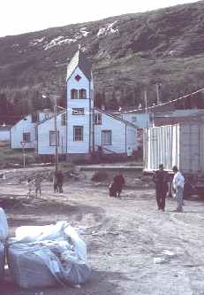
| Wooden Shoe, Cartwright |
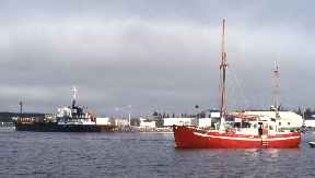
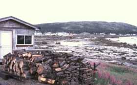
At 1900 we tied up for the night in a small fjord on an abandoned wharf in a deserted village. The next day brought fine weather, lots of bergs, and allowed us to make excellent progress until we anchored in a “tickle”, the regional name for pass, outside Domino. Here we watched Minke whales feeding at sunset. Another long day brought us to Cartwright, named for 18th century merchant and adventurer George Cartwright, now a small fishing port and regional service center for the many small out-ports in the area. A coastal freighter/passenger liner calls here regularly, and an airstrip provides service to Goose Bay, where the old NATO air base now serves as the area’s “International Airport”. On our first day ashore we met Randy Cahill, a Newfoundlander, who runs a marine services business and owns an ex-RCMP patrol boat that he charters out. Randy was nice enough to loan us charts on areas that we had been unable to purchase while in Halifax. We also met our first cruisers in Labrador, Jens and Gia on “Little Bear”, their husky red wooden North Sea workboat style motor sailor, who were bound to Kittery, ME after 4 years in Greenland. As the “Little Bear” reminded Mark of a pair of red Danish wooden shoes that he had as a kid, and as it seemed so fitting given the nautical nursery rhyme, “Winkin’, Blinkin’, and Nod sailed off in a wooden shoe…”, we forever after referred to this able little ship as the “Wooden Shoe”. Jens recommended an anchorage in the approach to Nain, and unable to pronounce its Inuit name, we noted it as Wooden Shoe Cove on our charts.
After two days in Cartwright, we headed past the Wonder Strand, a 26 mile long sandy beach that was remarkable enough to Leif Erickson that it’s referred to in the Icelandic Sagas. This reference was one of the keys to locating the L’Anse aux Meadows site in the early 1960’s. The Strand leads to the crossing of Hamilton Inlet, the 140 mile long fjord that serves as the entrance to Goose Bay. This area is swarming with hundreds of Common Puffins, Murres and Razorbills flying to and from their rookeries located on offshore outcrops. Icebergs become more common offshore, littering the horizon.
 |
| Makkovik, Labrador |
It’s two days journey to Makkovik, our first native village and a Moravian missionary site. It was while visiting the village’s small museum we first saw pictures of the abandoned mission at Hebron and realized that we had to make the extra effort to get there and see it for ourselves. Makkovik is a very well organized, friendly village. While tied up to the public wharf, we observed the common docking procedure of the local coastal freighters. As large wharves are not feasible due to cost and location, the ships are instead moored stern-to on the wharf, enabling them to lower a stern ramp for vehicles and roll-on/roll off cargo. This necessitates dropping anchor off the wharf, pivoting on the chain, and then backing down until mooring lines can be passed ashore. In the confined harbors, without bow thrusters or even twin-screw propulsion, this requires an extraordinary degree of seamanship.
 |
| Moravian Mission |
One day’s passage through the many islands and outcrops lays Hopedale, a Moravian village established in 1782 by Jens Haven. Haven, a Dane, was a master carpenter who felt called to the church. Aware of the tragic attempt by the Moravians to establish a mission near Makkovik in 1759, Havens studied Native language and custom in Greenland before making three reconnaissance voyages to Labrador. This preparation allowed Havens to avoid the violent confrontation with the Inuit that had. Aware of the tragic attempt by the Moravians to establish a mission near Makkovik in 1759, Havens studied Native language and custom in Greenland before making three reconnaissance voyages to Labrador. This preparation allowed Havens to avoid the violent confrontation with the Inuit that had scuttled the 1752 attempt, and enabled the future success of numerous Moravian mission sites. An original mission building remains in Hopedale, and is the oldest wooden structure east of Quebec. However we decided to save a visit to the mission for our return trip.
|
|
| Nain, Labrador |
After waiting out a 35-knot gale, we headed north for Nain. The two-day trip took us through an area reminiscent of Yosemite and the High Sierra’s, with granite outcrops, dome features, and glacial carved valleys. Nain is the northernmost inhabited village on the Labrador coast. It was the first Moravian mission in Labrador, established in 1771. Jens Haven and three other Europeans had erected their prefabricated timber-framed building on land granted by the English Crown, and initiated mission and trading activities in that year. The Crown facilitated this effort, as it furthered the English policy of precluding intrusion by the French, and was an area that the Crown monopoly Hudson Bay Company had ignored. Thus the missions could bring the influence of the Crown to the region, while costing the exchequer nothing, as the missions were to be self supported by trade in furs and fish. Today the village runs a quarry mining labradorite, a granitic type rock (anorthasite) used to make 12”x12” floor tiles, and serves as a regional government and service center. We tied up next to the quarry tugboat at the village dock while we fueled, and were given tile samples and our first real look at labradorite, a spectacular luminescent blue crystal.
Four hours north of Nain, in the narrow Manver’s Run, we encountered our second cruising boat, “Ursus”, skippered by an older American from New York with two younger crew, who had gotten as far as Mugford, another day and a half north, and were now heading south. Through our brief conversation with them we learned of a morning radio schedule with the “Belvedere”, a well-known 50 ft. steel motor-sailor owned by anthropologist and historian John Bocstace, of New Bedford. Bocstace and the “Belvedere” had transited the North West Passage some years earlier, and as Mark has collected and read nearly everything ever written regarding such endeavors, he was familiar with her. It was nice to know, now that we would be on our own, far beyond any village, that we’d at least be in touch with others.