
|
|

|
|

|
|

|
|

|
|

|
|

|
Kentucky Fall Color Blog
Here are a few extra pictures and tidbits from the trip:
- At the first two McDonald's I went to in Kentucky, and ice cream cone cost 73 say-ents.
- I had the most terrible time opening rooms in my hotel. My room key (card) scanned correctly every time, but the lock wouldn't catch. I had to try 4-5 times almost every time to enter my room. On the one night I went to the pool, I had to use my card to enter the pool area, and again, it took about 4 tries to enter the room. No wonder I had the pool to myself.
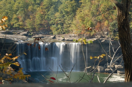
- Here is another view of Cumberland Falls:
By the way, getting a large coffee from Starbucks just before visiting the waterfalls may not have been the best idea. At least the park was set up with a restroom near the falls.
- Other than the hotel and gas, I didn't spend more than $6 at any one time. None of the parks I visited, state or national, had admission fees. While I found that extremely cool, it made me wonder why Indiana not only charges a small fee to enter its parks, but also makes you pack out your own trash. Indiana and Kentucky charges the same sales tax, Indiana's cigarette and gasoline taxes (99.5 cents/pack and 29.6 cents/gallon) are much higher than Kentucky's (30 cents/pack and 18.5 cents/gallon). Kentucky does tax property at the state level and their income tax rates vary from 2 to 6 percent (Indiana is fixed at 3.4 percent). All in all, it makes me wonder where Indiana's money is going.
-
The air near mile marker 45 on the Cumberland Parkway smells like raw onions. A couple of places near Lake Cumberland state park had a similar smell.
-
The first night I was in the hotel, I saw a TV commercial advertising riding lawnmowers. The ad was touting the how fast the mowers were, as though they were intended for racing.
-
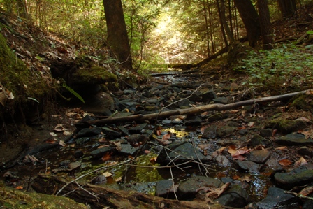
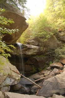
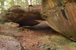
Here is another picture of Anvil Branch in Cumberland Falls State Park:
-
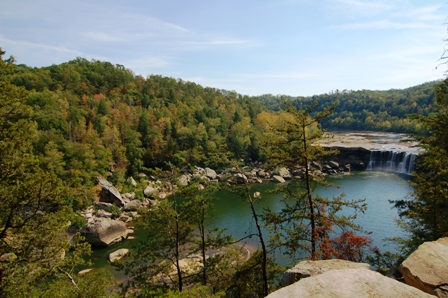
Here is the view of Cumberland Falls area from the Eagle Falls (elevated) trail:
-
There is a Kingsford Charcoal plant in Burnside, Kentucky. An appropriate city, to be sure.
-
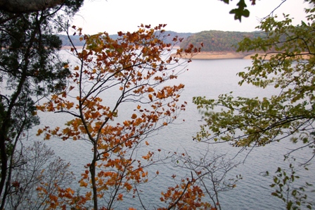
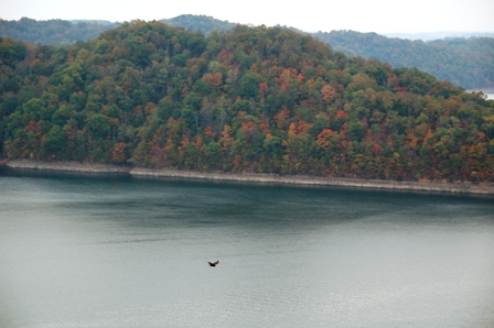
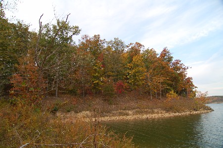
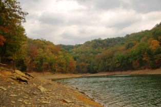
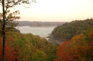
Here is one of the views of Lake Cumberland from by first visit when I tried to hike and beat the darkness:
-
You know how you see these pictures in emails of "redneck" living and of the stereotype of mobile and "improvised" homes that goes along with the hills of Kentucky? There's a reason for the stereotype. I didn't stop to take any pictures of these types of sights, but I saw plenty. The one that stuck out in my mind the most was a houseboat near Dale Hollow. The boat was not on or near the lake, but it was up on blocks and appeared to be being used as a residence. Not only was it on blocks, but it was 2-3 feet in the air on blocks. Wouldn't a houseboat kind of be the ultimate protection against flood? Wouldn't you only need an anchor laying out?
-
Here is another view of Dale Hollow from the elevated viewing area:
-
When walking the Boom Ridge Trail in Dale Hollow, this was all I saw to let me know I was entering Tennessee:
-
This is an example of me playing with the macro mode on my pocket camera in Dale Hollow:
-
I spent a lot of time on Kentucky's two-lane highways and learned a couple of things. There seem to be an endless series of short passing and no passing zones. Some of the passing zones are so short that you could hardly pass a lawnmower (not the kind advertised on TV) in the amount of space provided (I counted some that were as short as 8 or 9 dashed lines). I also learned that if there is a sign for a curve that says 40 MPH, I had better go 40 MPH. In Indiana, if the sign says 40, I can usually take the curve at 55.
-
Here is as close as I got to a deer on the trip. I was in my car at Mammoth Cave:
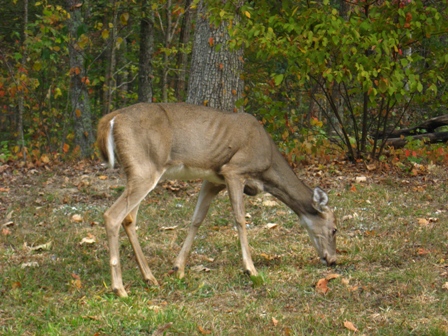
When I was walking and any deer were nearby, they would generally run away as fast as they could, but when I was driving and they were in or near the road, they didn't seem to care. After seeing 2 or 3 deer in the roads and at least a dozen near the road, I was getting so paranoid that at one point I actually slowed down for someone's garbage by the side of the road because I thought it looked like a deer.
-
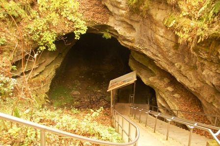
I didn't go into any caves, but I did walk past the "Historic Entrance" at Mammoth Cave:
-
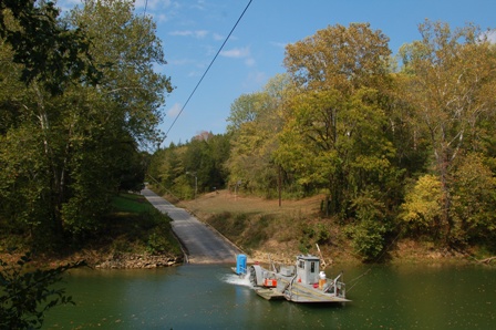
Brooke practically begged me not to take the ferry at Mammoth Cave because she figured it might sink. Well, here is the mighty Green River ferry:
-
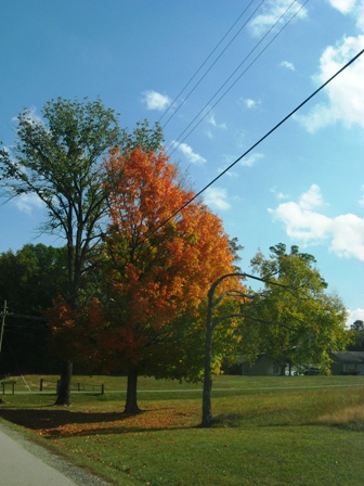
I don't know what it was about this colorful tree in Barren River Lake State Park, but I felt compelled to go back into the park (I had to leave the main part of the park to walk on one of the trails) to take a picture of it:
-
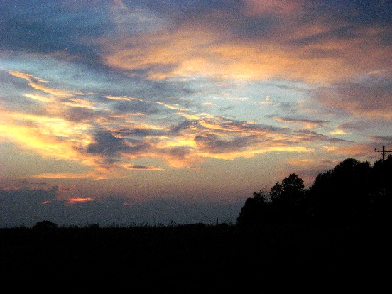
Here is another of the twilight views at Green River Lake State Park just as I was about to leave:
Wednesday, October 17 - Animals, River Lakes, Then Home
I was surprised at how good I felt when I woke up on my last day in Kentucky, but I was definitely glad to be going home that night. I had planned on leaving no later than 5:00, but I know myself well enough to know that I would stay as long as there was light. I was correct.
I started the day at Mammoth Cave National Park. I really had no intention of going into the caves, but I did went to spend some more time in the park that was closest to my hotel and I chose the surface trails near the visitor's center. Most of the scenery was unremarkable, but I got there early enough that there weren't many people and some animals were still visible. The deer and squirrels still ran away too fast for pictures, but other animals aren't so agile:
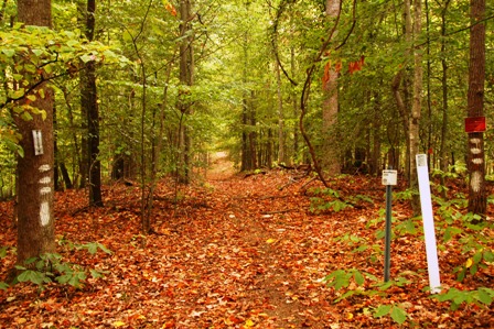
I then proceeded to walk along some trails that followed the Green River and found one decent viewing point:
I also walked past some of the other formations, like Echo Springs and Mammoth Dome Sink (whatever that is). The one whose name I liked best was the River Styx Spring. As I recall, in ancient Greek Mythology, the River Styx was the river to the underworld, and it seemed a perfect place to visit so close to Halloween.
After leaving Mammoth Cave, I proceeded to Barren River Lake State Park, despite it having an unattractive name (kind of like "Sarah Shank Golf Course"). It only had two short trails and a "beach" and it pretty much looked like all of the other parks. In fact, if it weren't for the lodge, I would have thought this to be more like a city park. I walked the two trails anyway, and was very pleasantly surprised: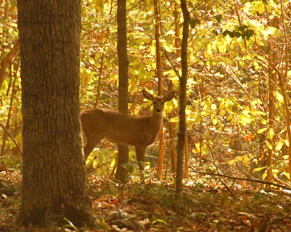
I had seen several deer in the woods on some of my other walks, but they usually skittered way as soon as they saw me (and I don't make any efforts at camouflage or stealth). However, I saw two of them and they started to move off, but I stood still long enough that they just decided to stare at me for a while. One of them even laid back down. But I had to press on and they ran away. I was happy to finally get a picture after seeing so many run away.
From there, I knew I wouldn't have much daylight if I decided to go on to Green River Lake State Park, but of course, I went anyway. I started to walk on one of the trails, but I didn't have a map and I quickly saw that I wasn't where I thought I was, so I went in search of a map. I actually found the "beach" first:
Nearby was the camp store and I was able to get a map and make a mad dash to what I determined were the most scenic areas (on the trails designated as "easy"). My final hiking descent led me to here:
Then one last time, I raced the darkness back to the car (I won again!) and got ready for the long trip home. I didn't get home until close to 11:30 at night, but I felt satisfied that I had done everything I had intended to do, and a little more.
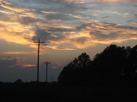
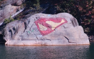
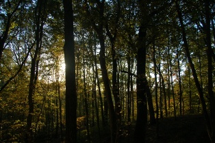
So the trip is over, but the blog will continue one more day. I've accumulated little tidbits of information and some bonus pictures that didn't really fit into the stories I've already told, so I will work on posting those tonight. In the meantime, here is one of the last pictures I took on the trip, and I think it makes a good lasting image:
Tuesday, October 16 - Too Much Water and Walking To Tennessee
I was really looking forward to today after seeing the colors at Lake Cumberland yesterday and I expected to see something similar at Dale Hollow State Park. I was certainly not disappointed in the view of the trees, but it was an overcast day with intermittent rain, and clouds rarely do anything to enhance photography. As a result, I got to try a lot of different things with my camera settings; I took over 200 pictures, but probably of only about 10 things because it seemed like I took 20 pictures of everything. The magic of digital photography.
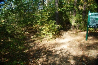
I got to Dale Hollow and had the familiar problem of not having anywhere to park near the trail I wanted to get to, so by the time I found a place to park, I was near other trails that I didn't plan to take. But the first one I saw was only 0.2 miles, so I thought I would try it. I think the distance was vertical because it did nothing but go down and I couldn't envision it ending up anywhere interesting. So after 5-10 minutes of descending, I went back up (and fought off the first of two major rebellions by my legs on the day) and headed for the Eagle Point Trail that I originally wanted to take. After some more "stock market" hiking (up and down and up and down), I ended up at an elevated lookout with a pretty nice view:
Now the light was not great for pictures, but I was tired and felt that this was a great place to rest and take about a hundred pictures in between rain showers, including this one of the park lodge:
The knowledge that there was lunch in the car motivated me to head back without too much trouble. (I think the packet of trail mix that I ate on the way up was the only thing that got me there.) Then I headed for the main trail of the park, the Boom Ridge Trail. This trail has several spurs that all appear to go to the edges of the main peninsula of the park. The main trail actually extends into Tennessee (where instead of a sign saying "Welcome To Tennessee", there were signs saying something like "BOUNDARY: Do not sess with this sign by order of the Army Corps of Engineers), and I decided to take that one all the way out and maybe take a spur or two on the way back. The main trail was actually fairly tame as far as elevation changes until I got almost to the end and saw the all-too-familiar descent that appeared to be heading to the water. I really didn't want to go down there, but I thought "I walked all the way to Tennessee to take this trail and I am going to the end!" And here is what I could see at the bottom:
I made my way back up and decided that I had enough energy to try one of the spurs and make one last climb, so I chose one that was 0.8 miles. I don't know how far I got, but after 10-15 minutes I got to a point where the trail appeared to either split or end and I couldn't find any trail markings ahead (the marking at the "split" was the first I had seen for about a quarter mile), so I decided that I had seen enough of the park and went back to the car to move on.
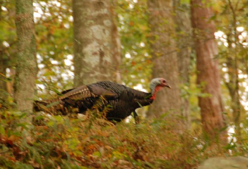
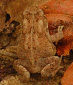
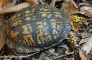
Most of the hikes were faily uninteresting as far as views of fall colors were concerned, but I saw lots of animals, most of which ran away before I could get pictures of them. I got a fuzzy picture of a deer just as I got out of the car the first time, I saw lots of gray squirrels and chipmunks and at one point, I think I saw three wild turkeys (I've never seen a wild turkey in the open before, so I am assuming a bit, but these three large birds waddled away very quickly when they heard me coming). Out of all the animals I saw, only these stuck around to have their pictures taken:
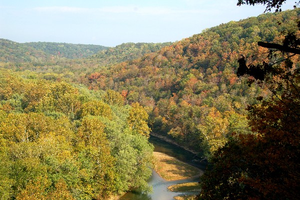
I changed plans a little bit when the sun decided to show itself and I decided to head back to Lake Cumberland State Park to see what photo opportunity I missed. On the way there, I stopped at the Wolf Creek Dam Overlook (the sign said "overlook", I have cameras, I stopped). I wasn't sure where the prime viewing spot was, so I took the short walk to the first view I could find:
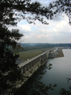
Little did I know that after I was done taking pictures, I ended up driving on the dam. And speaking of dams, we don't really have these in Indiana, do we? What is their purpose here? Almost every body of water I have visited so far or will visit tomorrow has been artificially created by dams. I knew I would regret not studying civil engineering (well, not that much).
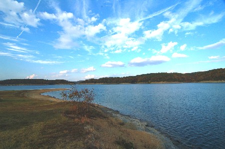
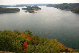
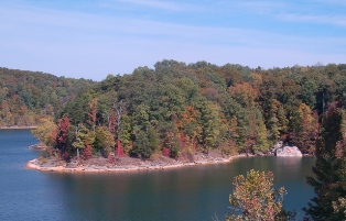
Anyway, I got back to Lake Cumberland State Park and was thankful that the scenic view was one where you just park and go up a couple of steps. I had already converted to "lazy photography" mode (i.e., I changed out of my hiking shoes and took pictures with the small camera as I was driving). I took one look at the view and got the "Ted's Aquamarine" advertising jingle stuck in my head:
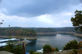
In that picture, I tried to keep the boats to a minimum, but there was no view that didn't involve a lot of boats. There must have been hundreds.
I had originally entertained the idea of finishing the day by going to Barren River Lake State Park, but rather than play "Beat the Darkness" again, I took it easy and explored somewhere a little more familiar:

I also went to Wal-Mart to look for more snacks. (And also because going to Wal-Mart in Kentucky is like going to see zoo animals in their natural habitat, right?) I actually made it back to the hotel with a sliver of daylight left for the first time on this trip.
So tomorrow I am planning to go back to Mammoth Cave National Park. I don't know what I'm going to do there, whether I just stick to the trails near the visitor center or look into taking a cave tour (although I don't think I'm ready to take on cave photography), but I'm going to go. Then I'm planning to go to Barren River Lake, but if time is short, I think I can pass on that. It may have a good chance of having fall colors, but there are only two short trails. Finally, I'm planning to go to Green River Lake State Park which features lots of trails. From there, I will finally head home. I don't know when I'll get in, but I'm really looking forward to getting home (not as much as my feet and legs are).Monday, October 15 - Finding Some Falls and Fall Colors
I got an early start today (well, not really early; Cave City is an hour behind Indianapolis, so it seemed early) as I had a busy schedule. I also made it more busy by making stuff up as I went along
I headed out on the two-hour-plus drive to Cumberland Falls State Park, which is advertised as "Kentucky's Niagara Of The South":
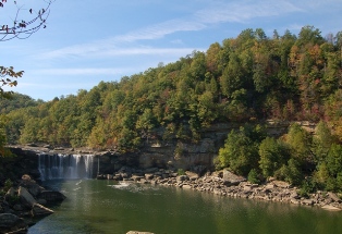
I have never been to Niagara Falls, but I somehow doubt this really compares. However, it was pretty cool. Cumberland Falls is also advertised as one of only two places in the world where you can see a "moonbow". A moonbow is a rainbow formed by moonlight. As the full moon as over a week away, I settled for sun:
Of course, this is the main attraction of the park, so it was easily accessible. But there were a lot of other trails in the park, and I wanted to see what was "less accessible". So I chose to hike to "Anvil Branch". This involved first looking 15 minutes for a place to park (the trail access was on the road where there was no parking). Then it involves going downhill, uphill, steadily down, then steeply down until you get to "Anvil Branch":
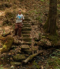
Other than lots of steps (the climb back wore me out for the first of several times today), there really wasn't much to see here, but it did give me an opportunity to finally get myself into a picture. This trail is advertised as having great views of wildflowers. I never realized that moss was a wildflower.
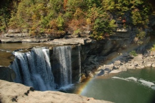
My last hike in this park was to a place called "Eagle Falls". I should have learned from my previous hike that the trail descriptions conveniently neglect to mention the elevation changes (unlike National Parks and Indiana State Parks, Kenutcky doesn't rate its trails on level of difficulty, not that it would have stopped me). This trail followed the other side of the river (opposite where I took the first two pictures from) and went up, up, and up. There was a gorge overlook that was almost nothing but stairs for a tenth of a mile. I climbed it and found that the overlook had no view because there were trees in front of it. I then proceeded to the falls, and that meant going down all of the distance I had just climbed (I didn't measure, but I am sure it was several miles). OK, the entire hike was supposed to be 1 mile (each way), and I would say three-fourths of it was steps, and this was the payoff at the end:
Well, it was good exercise right? Oh, you mean I have to walk back this way? If the earth suffered any kind of oxygen shortage today, I think I used all of it to get back to my car.
Not having had enough punishment for one day, I saw in the Cumberland Falls guide that if I drove 20 miles to a place called Yahoo Falls (in Big South Fork National River and Recreation Area that was over a 100-foot-tall waterfall (Cumberland Falls is 60 feet). The thing that really sold me though was that it was only a quarter-mile walk from the parking area. So I drove the 20 miles (about 45 minutes on the twisty, hilly road) and started to walk and saw that I could choose the short way and go down lots of steps or go a little longer on a mostly level path for three-quarters of a mile. I had enough steps, so I took the long way and when I got around where the falls were supposed to be, I heard virtually no sound. The little creek had some water in it, but it wasn't flowing. Based on that, I presumed the waterfall was dry, so I never bothered walking to the bottom. However, I can say that you can see that it is a very long way down from the top of the falls.
Now this trip wasn't a total loss; at the top of the "falls", there was a spur leading to a place called "Yahoo Arch", and since it was advertised as 0.8 miles (and didn't look like a steep climb, at first). There was some climbing, but it led to this formation:
There wasn't any sign that said "Congratulations! Welcome to Yahoo Arch!", so I wasn't sure at first if this was the end of the trail, and I saw a trail that continued past the arch, so I walked (climbed) it a few more minutes until I decided that it didn't go anywhere interesting, so I turned around and headed back to the car. It is a good thing I did because as I was driving out of the park, I saw that the trail ended up at the side of the road 1.2 miles past the arch. If I had kept going, I would have had a nearly 3 mile downhill hike back to the car (and downhill is not as good as it sounds; uphill strains the lungs, but you recover after a brief cooling off, while downhill strains the leg muscles and feet and joints, and those don't recover as quickly and you are much more likely to fall).
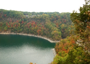
So that was a full day, right? NO! I still had just enough time to try to get some pictures from Lake Cumberland State Park which was only 20 minutes off my route back to the hotel. For the second straight day, I raced against the sunset to get to the advertised lookout (yet another downstairs/downhill/uphill hike) only to see the lookout had no view because of trees. I will say that the colors were really cool, both what I could see in the distance and where I was standing, and I got to see a lot of gray squirrels running away from me (it's a little unusual for me to see gray squirrels since we only have the fox squirrels in my neighborhood) that I couldn't take a picture of because forests block light and are tehrefore not conducive to photography. I still snapped a bunch of pictures, and here is one of the better views I could find:
And now I have to admit that I took that picture from an overlook at the side of the road (where I hiked about 0.01 miles to take the picture). There was one other "lookout" that I could have hiked to, but I doubt I would have seen anything much different than what I saw at the other two lookouts (since I doubt they had any waterfalls or arches).
Anyway, I finally headed back to the hotel, but I didn't get very far before I had to slam on the brakes to miss the first of two road-walking deer I would encounter. I was tense driving the whole way back since it was the second straight night where I saw multiple deer near the road (I even saw two near my hiking trail at Mammoth Cave yesterday). Despite my heightened awareness, I still managed to hit something on the Cumberland Parkway; I definitely felt it, but I didn't know what it was and it didn't damage the car. I think it was a truck tire tread; at least I hope it was. I relieved the tension by getting a McDonald's ice cream cone. (Yahoo! Arches!)
So I'm going to rest tomorrow, right? WRONG! Tomorrow is a big day of exploration at Dale Hollow State Park. Now I don't know how hilly it will be there, but that will definitely influence how much ground I cover. If there is time afterwards, I may also go to Barren River Lake State Park. (I know that "Barren" makes it sound deserted, but Barren is the name of the county, so that means there is hope that it isn't "barren", right?). Of course, it is possible that my legs and feet will have completely abandoned me by the time I wake up tomorrow, but I am really looking forward to going the Dale Hollow which I think will be my last chance to get pictures of the colorful forests.Sunday, October 14 - I Thought "Dry County" Meant Something Else
First of all, I made it here to Cave City OK after only getting lost a couple of times. Well, lost in the car, anyway. Actually, it was kind of a "lost" day all around.
My first stop today was Nolin Lake State Park. Before you get to the actual park, there is Nolin River Dam, where I stopped to get a look at the mix of colors:
Now the colors in this area are only beginning to turn, but the colors that caught my eye were on the rock in the bottom right:
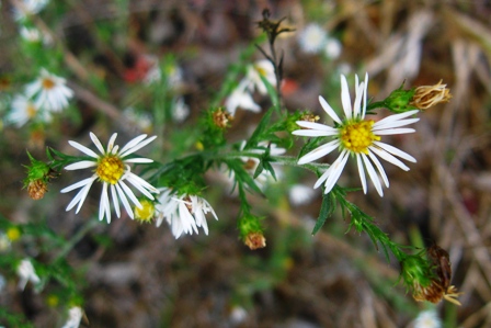
After this stop, I made it to the park. This particular park is not really a nature park, but the web site advertised a nature trail to a waterfall, and my camera was very interested in seeing it. So I got there and started on the trail (after a brief stop to take pictures of the first of 10,000 spiders I saw today) and after about 500 feet, I lost track of the trail. I soldiered on though. And on. And on. And on. I never really found the trail again, but I did find thorns, spiders, cockleburs, spiders, trash from years ago (I was a "Pepsi Free" can), rock outcroppings, and spiders. On the bright side, I did see a couple of these:
After a lot of walking, I gave up on the waterfall and stumbled back to the car and when I got to the trailhead, I realized that I was never on the trail in the first place! The map shows that the trail splits at the head and forms a loop, and it looked that way when I was there:
Well, I went on the trail to the left originally (that is where the waterfall was shown), and that didn't go so well. It turns out that you walk about a half mile before the trail splits into a loop. In hopes of salvaging the trip to this park, I went ahead on the real trail (which I figured out was marked by blue and red flags tied to tries or on the ground; this is not explained anywhere). I eventually found the advertised waterfall, only to find that it was dry. I took pictures anyway, but a waterless waterfall really just looks like rocks.
After this experience, I went to Mammoth Cave National Park. I decided to hike on the north side of the park (the less popular side) to an area that was on the map in the middle of a horseshoe-shaped bend in the Green River. However, a mile into the 3-mile trail, I got tempted by a fork in the trail that led to another waterfall. You would have thought the I had learned. After about a mile detour that resulted in me not finding the waterfall (I was running out of daylight to keep looking for it), I eventually walked the length of the trail to find that it ended in a campsite and did NOT have a view of the river. And since this area is all forest, there is very little light and it doesn't lend itself to good pictures. I snapped very few, but here is one to prove I was there:
I did make it back to my car with a little daylight to spare. I drove through the park to take the shortest route to Cave City (including riding a ferry in my car for the first time) and avoided the numerous deer to get to my hotel room where I can get rested up for tomorrow.
Now, after my experience today, you might think I would not be inclined to go to Cumberland Falls State Park, but it appears to have plenty of trails, so I will at least get some more exercise. However, if their name is "Cumberland Falls" and their waterfall is dry, I'll know I am cursed. I may also go to Lake Cumberland State Park. Either way, I'm hoping the camera will find something.Tuesday, October 9 - Really? Kentucky?
Yes, Kentucky. I know that I've said a lot about Kentucky in the past and how it rhymes with so many of its synonyms, but it contains many trees, lakes, and caves. With the weather finally cooling off, I'm looking forward to capturing some fall colors with my camera.
I'm planning to go to several places during my brief trip from October 14-17: Mammoth Cave, Lake Cumberland State Resort Park, Dale Hollow Lake State Resort Park, and who knows where else. I will plan to post pictures each evening, so check back in the mornings on October 15-17!
Blog Archive
Home
