|
|

Dikasalarin is a secluded cove located about 20 kilometers southeast of the more
accessible Sabang beach in Baler. It's a favorite picnic site of the Baler locals
and is one of the most beatiful beaches in Aurora. It's accessible via boat or land but
there's no road leading directly to the area. By boat it's only a 45-minute ride along the
shoreline of Baler. You can start your boat ride from Sabang or the Duongan river,
entering the sea through the delta of the Pingit-Kinalapan river at Sitio Castillo, then
riding the waves along the shorelines of Cemento and Digisit. Along the way you will have
a magnificent view of Baler from the sea, its endless beaches, the coconut-hemmed skyline
and gentle mountain slopes. If your boatman is adventurous enough, he can glide your boat
between the rocks of Lukso-lukso or take you on a slight detour under the cliffs of the
Anyaw island. Then you can marvel at the crystal-clear waters and the bed of corals
visible just below the surface. If you reached the point of Cape Encanto where the tip of
the mountain is bare but for gently swaying cogon grasses, then Dikasalarin is not that
far. From there the boat will take a right turn, glide under the shadow of hundred foot
cliffs, roll over 15 foot waves coming from the cove and then - paradise. By land its a different story. There are two ways to get to
Dikasalarin via land, both requires mountaineering skills. If you're physically
challenged, you can reduce hiking time by taking a ride up to the foot of point Encanto,
the mountain now called Pagasa because a weather station of the said agency is located at
the top. If you're riding a 4-wheel drive vehicle you can cut the trek even shorter
because a steep road accessible only to off-road 4WD's goes all the way to the weather
station at the top. From there you only need to climb down the mountain to Dikasalarin.
But if you can manage only a tricycle ride, then the trek up the mountain is unescapable.
From the Poblacion, your ride will take you around Barangay Pingit where you will cross
the bridge across the Kinalapan River then you will ride through the Pingit proper, Sitio
Puntangan and Dicaloyungan, another picnic site. Dicaloyungan River is now traversed by a
box culvert bridge and the road up to the ASCOT site is now concreted. After the
villa-looking ASCOT building, your trip will take you to the foot of the Ermita Hill just
across the delta community of Sitio Castillo. Turning around the foot of the hill you will
reach Cemento, another fishing village with marvelous fine, gray sand beaches. Crossing
the Dibitognin river and about a mile into coconut and cogonal fields, you will reach the
Baler Fish Port, now with newly constructed facilities. The road continues on - sometimes
smooth, sometimes potholed, sometimes dry, sometimes mud-filled and resembles a rice paddy
more than a road - and traverses the beach resorts that lined the reef coasts of
Dimadimalangat and Digisit. The road here is on the edge of the mountain and there are a
number of waterfalls with streams flowing across it. The trip in this area is a roller
coaster ride, sometimes on flat ground and sometimes cutting off the side of the mountain
and rising to a few hundred feet providing a magnificent view of the seascapes on the left
side of the road. You can marvel at the panoramic view of mountains dissolving into blue
undulations of waves that stretches from Baler to Casiguran. Sometimes you can't tell
where the sea ends and the sky begins. The trip will end at the foot of the Pagasa point
into coconut and secondary growth forests. But the road continues up to the top of the
mountain where the weather station is located.
If you're into trekking mood, you can walk all the way from
Sabang to Dikasalarin. Your trek will start with a boat ride, what we Baler locals call badeo,
across the river isolating Sitio Castillo from the rest of Brgy. Sabang. The fee is
two pesos. A bridge is now being constructed to traverse the river. After the badeo
you will walk across Castillo, one of the earliest settlements in Baler. It's situated on
the delta of the Pingit-Kinalapan river and often falls prey to the whims of mother nature
- sometimes tides of waves or river channels shifting locations. Then you will be on the
road at the foot of Ermita Hill. From there you can follow the road that leads to the foot
of PAGASA or if accessible, you can divert to the shorelines to get more of the nature
feel. This is one of my favorite trek routes and I have gone on several walks since high
school, some up only to the port, some all the way to Digisit and twice we hiked all the
way to Dikasalarin. Sabang to Dikasalarin takes 4 to 5 hours of leisurely walk. The first
time, we reached the place at around 5 pm and a trek back means an evening affair.
Luckily, a Castillo resident was generous enough to hitch us on his boat. The second time
we spent the night at the then abandoned weather station and trekked down to eat Lucky Me
breakfast near the mouth of the small river flowing through the beach. Then we headed back
up the mountains and down to the valley.
On the third week of March an outdoors club I was involved
in was invited by the Buklod Anyaw (a local environment group) to participate in a
friendship climb of Dikasalarin organized by the Pilipinas Sierra - a mountaineering group
based in Manila. It would involve about 4 busloads of city slickers and definitely the
first time that an affair of this magnitute would happen in Baler. So with the thought
that this could begin a rush of ground stomping unparalled in the history of Aurora we
locals might as well join in the stomping. And it also means that after this, Dikasalarin
will be a secret no more. The whole gig even had a 100 peso fee for ID and certificate.
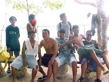
Our team was not used to mass climbs and usually do treks
in small numbers. There were around 8 of us, me being the oldest. All the other kids are
students and not really trained in mountaineering since their outdoors group is only 6
months old. On March 17, Saturday, the group walked to the Ermita Hill to wait for the
City People to arrive. We were there early and ended up waiting for 3 hours. Looking at
our team, we didn't really look like mountaineers. We only had one big tent I managed to
borrow. But this one can accomodate one owner type jeep or about 15 persons. We stuffed it
in a big hiking bag- the only one in the group. Everyone else brought backpacks. For
utensils we grabbed pots and pans from our kitchens. We have no outdoor cooksets and
utensils. We were planning to show those city slickers how to really hike. We were
prepared to catch kibit and buting and light firewoods
using rock splinters. The real survivor type. Our foods were mostly canned items we
crammed in a box of gin. The biggest member of the posse, Richie volunteered to carry the
tent. One kid, obviously a Fred Durst fan even brought a cassette player and lots of Limp
Bizkit and Limp Bizkit-sounding tapes. For a trip that's supposed to get us reacquianted
with nature - a rap-rock music in the middle of the forest is annoying. But the kids
seemed to like it so I prepped myself for a hike without the sound of waves, or leaves
rushing, and birds singing. But instead I prepared for one with a soundtrack direct from
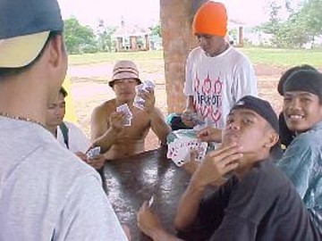
"Lock, Stock and Two Smoking Barrels". While waiting for the crowd to arrive, we
killed time by playing tong-its. And sleeping.
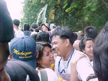
Around 10 am, the hikers arrived. Suddenly our hours of
trancendental meditation in front of the Grotto in Ermita were finished. Showing a fit of
hospitality we welcomed the visitors with cheers, hand waving and "rollin', rollin',
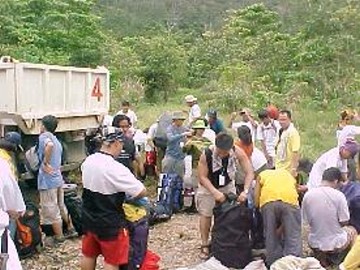
rollin'". The visitors were brought up in two giant dump trucks. One truck even made
a return trip to bring in all the 4 busloads of earthwalkers. I think there were about 200
of them. Some turned out to be balikbayans or Baler locals posing as tourist. I spotted
Jeho Bitancor and Arnel Querijero in the horde. There was a sort of welcome program in the
central hall of Ermita. The Tourism boss and other officials talked on things I can't
understand because of weak sound system. After about an hour of talking and picture taking
everyone crammed themselves in the 3 dump trucks. The scene was the computer equivalent of
turning the people into a ZIP file. Miraculously, the 4 busloads of participants plus the
Aurora kids managed to fit in the 3 trucks. There was total chaos on the truck we rode on.
There were about a hundred of us crammed like corned beef in a can. All were standing or
hanging from the side of the truck and grasping for breath and it felt like being rolled
in a transit mixer. The trip was a real "bonding" experience. Some held on to
their precious possessions like their girlfriends, a bunch of suman, or a
leaking bottle of Barangay Ginebra. Some cursed heaven and begged to be returned to the
City. Some managed to sleep. Everyone smelled like hell.
The trip to the foot of the Pagasa where the trek would
begin was an hour of hell. The view of endless beaches and waterfalls along the road was
no conciliation from trying to stay upright and conscious. When we reached the jump-off
point, everyone peeled and unglued themselves from each other and jumped off the truck to
breath fresh air. By then it's already noon and some started eating lunch. We decided to
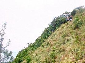
eat when we reach Dikasalarin. We were among the first hikers to ascend the mountain
separating us from our destination. The mountain is about 200 meters and we were walking
on an inclined road that is sometimes paved with concrete and sometimes paved with
boulders. It was laid like a giant anaconda with sharp curves and turns that added to the
distance of the climb. We were halfway up the 45 degree road when nature cooperated and
rationed some rain. I do treks like tuning a piano - about twice a year and climbing up a
steep incline with fully loaded backback and soaking wet was real punishment. It took us
about an hour to manage the mountain. At the top, and if you know where to look - go just
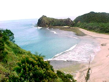
outside the Pagasa gate - the view of Dikasalarin below was spectacular. The beach is
pearl white and the water along the shore is crystal clear with tints of blue and green.
That's were we're going - it's beautiful and its far.
After about 5 minutes of taking in the scenery we started
the descent. There's no road this time but a trail created by kibit and buting
harvesters. The trail is a steep decline through a real jungle of thick trees, slimy rocks
and mud. On occasions when our Limp Bizkit fanatic with a boombox got too far you can hear
the waves and the birds. The descent took about 45 to 60 minutes and the trail opened to
the reef coast of Dikasalarin's West beach. The beach is made up of off-white
colored crushed corals and shells and it is lined with black dead coral reef. Not a good
place to swim in but the waves are good for surfing. Our destination, is still a half-hour
trek and a mountain away. Walking on white crushed corals on a secluded place somewhere in
the pacific was one of a kind experience.
A mountain point separates the west beach from our final
destination. Usually when we locals go there and the tide is low we just walk across the
exposed reef on the foot of the mountain to reach the south beach. It's just five minutes
to glory. Since it's low tide, Richie our tent carrier who is familiar with the place went
that way but was promply sent back by the lead man who told him that everyone must climb
the mountain and not do a cutting trip. He made all of us go up the mountain once more
which at first seemed a bad idea since the point is only covered with grasses. One
mis-step and you'll fall crushed on the black reef below. We were really dead-tired of
walking and climbing the Pagasa mountain so we decided to eat lunch before we attack the
last obstacle. Lunch was an all sardines affair and it recharged us a bit. After
about thirty minutes of siesta and meditation we started to climb our second mountain for
the day. For about ten minutes up the mountain we hanged like monkeys on arm-sized trees
hanging from the steep slopes. There was really no trail we so have to blaze through thick
grasses and rolling rocks. After a while we were on open space, the part of the mountain
covered with only cogon grasses. A trail was visible and we had to manage it by crawling
and using the grasses as handles. The view below was scary. The other hikers looked like
ants from were we were standing. The ridge of the mountain is covered with bonsai-looking
trees hanging from exposed rocks. The view was magnificent. On the left, the rocky coral
reefs of the west beach, and on the right - Dikasalarin looking like paradise on earth.
The descent was even tougher because the trail was slippery. My Mojo gave up and its strap
gave up the ghost. So I have to trek down with one foot bare.
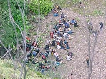
From the top we could already see some early birds setting
up their tents in the base camp. They looked like ants starting a colony of different
colored nylon tents. Climbing down was a very slippery job and it was even made harder
because of the rain that turned the ground into a virtual ricefield. The last few minutes
of the descent was back to the forest. By 2 o'clock in the afternoon we hit base camp, the
beach of Dikasalarin.
To be continued......
::
Top Of Page
Paleklek Homepage
Batangbaler Homepage
|
|