|
Canyonlands National Park
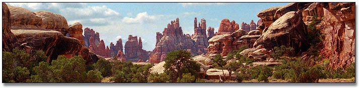
 Canyonlands National Park , Utah's seconnd largest national park, is a primitive geological wonderland preserving hundreds of colorful canyons, buttes, fins, arches, spires and hoodoos. The centerpiece of the park are the two great canyons carved through flat layers of sedimentary rock by the Colorado and Green rivers, which meet here in Canyonlands. The park is divided into 4 regions -- Island in the Sky, The Needles, The Maze and Horseshoe Canyon -- only two of which are accessible by highway. This 572 square miles of Great Basin Desert wilderness contains primarily unpaved roads and undeveloped trails. Canyonlands National Park , Utah's seconnd largest national park, is a primitive geological wonderland preserving hundreds of colorful canyons, buttes, fins, arches, spires and hoodoos. The centerpiece of the park are the two great canyons carved through flat layers of sedimentary rock by the Colorado and Green rivers, which meet here in Canyonlands. The park is divided into 4 regions -- Island in the Sky, The Needles, The Maze and Horseshoe Canyon -- only two of which are accessible by highway. This 572 square miles of Great Basin Desert wilderness contains primarily unpaved roads and undeveloped trails.
T
General Information
Rates & Fees
Entrance Fee: $10 for private vehicle, $5 per individual, good for seven days. Golden Age, Eagle, and Access available and honored.
Backcountry Permit Fees: Must be obtained in advance. See Permits for details.
Seasons / Hours
Canyonlands National Park is open year round except for some federal holidays. Visits may range from half a day to more than a week. Backcountry users will want to schedule more time to access remote locations. Spring and fall are the best times to visit, with May usually the busiest month.
Visitor Centers
Visitor Centers are open daily, 8:00 AM to 4:30 PM, extended hours spring and fall, closed some federal holidays.
Where to stay.
Island in the Sky District Visitor Center is located on Utah Route 113, west from U.S. 191, 32 miles southwest of Moab, Utah. Elevation 5920 feet.
The Needles District Visitor Center is located on Utah Route 211, west from U.S. 191, 49 miles northwest of Monticello, Utah. Elevation 4960 feet.
Information Center for The Maze District and the separate Horseshoe Canyon Unit is at the Hans Flat Ranger Station, 46 miles by unpaved road to Utah Route 24 north of Hanksville, UT. This facility is actually located in the Glen Canyon National
Stores/Museums
Books, maps, and other publications for sale at each location through the Canyonlands Natural History Association.
Programs & Events
Evening programs, overlook talks, and other walks or talks are provided at Çanyonlands. Check at visitor Centers for current schedule. Junior Ranger Program available for children 6-12.
Food/Supplies
There are no food and supplies available within the park. Gas, food and other items available spring through fall at the Needles Outpost, a private campground adjacent to the Needles District.
Accessibility
Island in the Sky is the most accessible area, with accessible Visitor Center, rest rooms and overlooks. Needles Visitor Center is also accessible.
General Rules
It is the visitor's responsibility to know and obey park rules. Regulations are designed for visitors' protection and to protect natural resources.
All state and federal laws are enforced in the park.
Parking is restricted to designated areas.
Wood gathering is prohibited.
No hunting or firearms are permitted.
Mountain bikes are allowed on established roads only.
Carry out all trash, including cigarette butts.
Pets are not allowed in the backcountry of Canyonlands National Park. This includes all four-wheel-drive roads and hiking trails. Pets on a leash 6 feet or less in length may accompany visitors in front-country areas, which include paved and two-wheel-drive dirt roads, and the Squaw Flat and Willow Flat campgrounds. Pets may not be left unattended, tied or physically confined in the front country to facilitate backcountry travel. Because bringing pets severely limits your options for exploring the backcountry, it is suggested that pets be left at home.
2282 S. West Resource Blvd.
Moab, UT 84532-8000
435-259-7164
Native Peoples
The first people known to inhabit Canyonlands were the Archaic hunter-gatherers, who wandered the area 2,000 to 10,000 years ago in search of large game animals and edible plants. They lived in the open or camped under overhangs, leaving behind such artifacts as projectile points, atlatls or spear throwers, fire hearths, and ghost-like pictographs.
By 2,000 years ago, these hunter-gatherers were cultivating corn and constructing slab-lined cists for storing the grains they collected. The Basketmaker agriculturists also constructed pit houses and made fine basketry. Around A.D. 450 they developed pottery, adopted the bow and arrow, and developed multi-roomed pueblos with ceremonial chambers known as kivas. The Basketmakers, and later Pueblo people, are now collectively referred to as the Ancestral Puebloans. By AD 1300 the Ancestral Puebloans left the region, perhaps because of climatic changes that made life difficult.
Exploration & Settlement
Ute, Navajo, and Paiute Indians occupied southern Utah when the Padres, Escalante and Dominguez circled Canyonlands in 1776, looking for a route between Santa Fe, New Mexico and Monterey, California. The United States recognized southern Utah as a Spanish possession with the signing of the Adams Onis treaty in 1819, but this did not deter trappers from entering the area in the early 1800s.
From 1836 through 1838, a trapper named Denis Julien left his name carved throughout the Canyonlands area, including the Colorado River canyon. The U.S. Army sent Captain John N. Macomb on an expedition to explore the Colorado Plateau for a wagon route from New Mexico to Utah in 1859. The expedition members drew the first accurate maps of southeast Utah and compiled geographical and geological information of the area.
River Exploration
Little was known of the Colorado River until 1869, when Major John Wesley Powell completed his first expedition from Green River, Utah through the Grand Canyon. Powell repeated the expedition in 1871-72, continuing his studies of the topography, natural history and Native American cultures. Bert Loper, Charles S. Russell, and E.R. Monett made the first pleasure run down the Colorado River through Cataract Canyon in 1907.
European Settlement
The first Europeans to settle the area were the cowboys. Al Scorup began grazing cattle in the White Canyon area near Natural Bridges in 1891 on his way to becoming one of the most influential ranchers in the region. Sheep were grazed on the Island after 1900. Cattle ranching encouraged cattle rustling, and the rugged canyons provided hideouts for such outlaws as Robert Leroy Parker (Butch Cassidy), Tom and Bill McCarthy, and Matt Warner. Robbers Roost, west of the Maze, served as a secluded refuge for such gangs.
In March 1883, the Denver & Rio Grande railroad joined with the Rio Grande Western railroad near Green River, Utah, providing rail transportation to southeastern Utah. This, combined with the removal of Native Americans to reservations during the late 1800s and early 1900s, nurtured the growth of farming and ranching communities in the area, such as Moab and Bluff.
In spite of the early settlers, much of the Canyonlands area remained relatively inaccessible until the uranium boom in the 1950s. After the atomic bombings in Japan ushered in the nuclear age, the Atomic Energy Commission offered monetary incentives for the discovery and delivery of uranium ore. The uranium-rich Canyonlands area lured prospectors who built many exploratory roads in search of the radioactive "gold," opening up miles of previously unexplored public lands.
T
Established as National Park: September 12, 1964
Park boundaries expanded: 1971
Arches National Monument Superintendent Bates Wilson first visited the area by horse in 1951, riding to the Confluence and up Salt Creek. His early mapping of archeological sites in Salt Creek and Horse Canyon spurred the interest of University of Utah archeologists. Wilson worked from 1951 to 1955 for an official National Park Service investigation of the area.
In 1957 he began leading visitors into the Canyonlands area, publicizing its scenic and recreational values, and recommending the creation of a "Grand View National Park." Secretary of the Interior, Stewart Udall, visited the area in 1961 and began campaigning for a national park on what were then Bureau of Land Management lands. On September 12, 1964, President Lyndon B. Johnson signed the bill establishing Canyonlands National Park, consisting of 257,640 acres. The park was expanded in 1971 to its present 337,570 acres.
T
Plants & Animals
A unique desert plant community that you are sure to see during your travels in canyon country is cryptobiotic crust. This crumbly, black soil crust is made up of fungi, lichen, algae, moss and bacteria all living together in a symbiotic relationship, one in which all the members benefit from their communal co-existence.
Cryptobiotic crusts are very important to the desert community because they stabilize the soil and make it less prone to erosion, make the soil more fertile by providing nutrients such as nitrogen, and soak up and hold water. A plant seed that lands in cryptobiotic crust has a greater chance of survival than one that lands in loose, dry sand. Unfortunately, cryptobiotic crusts are very fragile. One misplaced footstep can quickly turn crust to dust and recovery and regrowth may take decades. Please, watch your step, stay on the trail, hike on slickrock or in dry washes whenever possible.
Carnivores, like the coyote, bobcat, mountain lion and birds of prey, rely heavily on the fluids found within the animals they eat to supplement the water they drink. Fur and feathers can play a double role in some animals by shielding them from the sun during the day and insulating them from the cold at night.
Animals with a short sleek pelage are still able to lose heat fairly easily after exertion by laying the hair down flat. Birds can droop their wings down away from their bodies allowing heat to escape from their thinly feathered undersides. Birds and large mammals commonly pant as a means to increase heat loss.
Geology
Canyonlands National Park is a showcase of geology. The arid climate and sparse vegetation allow the exposure of large expanses of bare rock and the great canyons of the Colorado and Green Rivers reveal 300 million years of geologic history.
Canyonlands is located within a geologic region called the Colorado Plateau. It is a great section of continental crust that has endured millions of years of rock building and erosion. Advancing and retreating oceans left thick deposits of beach sands and marine limestones and buried sediment became solid rock as pressure from overlying layers and filtering water cemented them.
After millions of years the erosion that continues today began. Roughly 10 million years ago, plates in the Earth's crust moved so the western edge of the continent began to rise. The slowly rising land mass, including the Colorado Plateau, became higher and therefore more susceptible to erosion. Newly elevated highlands captured rain and snowfall and gave birth to the Colorado River system. The uplifting land caused rivers to down-cut faster, entrenching themselves in solid rock. The results are the 2,000-foot deep canyons of the Colorado and Green Rivers cutting through the heart of Canyonlands.
Canyonlands is one of the best places in the world to see classic landforms and the result of geologic processes. Much of our current understanding of the principles of geology come from this area when, in the late 1500s, geologists first studied the Colorado Plateau, reading the history of the Earth from one of its most exciting chapters.
Upheaval Dome: Island in the Sky
Joint Trail: Needles
Confluence Overlook: Needles.
Colorado and Green River canyons: To see a cross section of the park, take a trip by canoe, raft or jetboat through the canyons that created this landscape.
T
Canyons
Thunderstorms drop huge amounts of rain locally. With little soil and vegetation to hold the water, runoff is fast. It quickly collects in gullies and small washes, magnifying its power as water funnels into the canyons. The erosive power of the debris and sediment-laden water is tremendous. Flash floods are continually scouring and deepening the canyons.
Hoo Doos
In the Needles District, great systems of parallel cracks formed as overlying rock slid toward the Colorado River on the relatively slippery salt of the Paradox Formation. From high vantage points, a cracked checkerboard landscape is visible. Over time, rainwater and snow penetrate through weak joints. The cracks widen and erosion accelerates with increased surface area until only thin fins and "needles" of rock remain.
Soft rocks that would normally form slopes can also become spires if they have a layer of erosion resistant caprock on top. A good place to see caprock spires is Monument Basin, visible from Grandview Point in Island in the Sky.
FEEDBACK FROM READER
Hi! I was just browsing to see if any new articles had been published on my latest love ... The Upheaval Crater Complex just west of Moab, Utah. This area is in need of some serious study! Gene Shoemaker started the ball rolling, but his death in a car accident seems to have slowed down the process. Here are a few more bits you may want to add to your presentation. I haven't found accurate measurements on ANYTHING!
Briefly, halfway through the period of laying down the Navajo Sandstone (undisturbed in the half above the rift!) in a shallow sea, an asteroid (1600 ft di.) struck th water/sand at an angle of about 75 - 80 degrees traveling from south east to northwest at ???? speed. The gout of water/sand thrown out on initial impact carved the basis for Taylor Canyon to the northwest, while the angular down pressure began ripping a perpendicular rift (Robert's Rift) that moments later was about 50 miles long and two miles deep. As the sandstone formations were crushed downward, wavy funnels of sand were ejected at various areas around the parameter ranging from 60 ft. thick in the southeast to about three hundred feet in the northwest (omitting the area washed away by the initial gout).
The asteroid appears to have penetrated or compressed 6,500 ft. of strata, forcing the Hermosa Formation to shoot 2,500 ft. up into Robert's rift along with enough volatiles to blanch the red rocks white 20 ft. wide on both sides of the rift for 25 miles or so. As theshattered (?) asteroid rebounded, the now superheated groundwater addeda series ofsteam explosions to the rock rebound, doming a ten mile structure, andblasting thecentral three mile area away.
Heavy erosion in the area has removed most of the evidence, butshatter cones can still be found laying around, and the sandstoneexhibits shocked quartz. SALT? Ha!!!
All the clues are there. Your visitors would find it more interesting if they knew more about what they were looking at.
T
There is no lodging in Canyonlands National Park. Moab, Utah, 5 miles south on U.S. Route 191 offers numerous hotels, motels and bed and breakfasts, as well as commercial campgrounds, where showers may be obtained for a fee. For more information and a complete list. Click Here. (Rates, availability and reservation on line)
Park Campgrounds
The two front country campgrounds in Canyonlands National Park, Squaw Flat in the Needles District and Willow Flat in the Island in the Sky District, are available on a first-come, first-served basis only. The Needles District also has three campsites for groups of 11 or more people; group reservations are available. Vault toilets, picnic tables, and grills are provided. Have a back-up plan for finding a campsite outside the park if you are visiting during the peak seasons of spring and fall.
Park Backcountry Camping
There are numerous primitive campgrounds throughout the park and along 4-wheel-drive roads. Backcountry permits are required for all overnight stays in the backcountry. This includes backpacking, four-wheel drive or bicycle camping, flat water river trips on the Green or Colorado to the Confluence, and Cataract Canyon river trips. Permits are also required for day use by vehicles, horses, and bikes in Salt Creek/Horse Canyons and Lavender Canyon in the Needles District.
Reservations are highly recommended if you plan to visit Canyonlands National Park during peak season. During the spring and fall, demand for backpacking and four-wheel drive camping permits frequently exceeds the number available. Reservations must be made at least two weeks before a trip. The backcountry vehicle campsites along the White Rim Road are especially popular, and should be reserved at least six months in advance for peak times.
| Murphy Hogback Campsite |
White Rim Camping |
| Candlestick Campsite |
Shafer Canyon |
| Potato Bottom Campsite |
Airport Tower Campsite |
| Hardscrabble Bottom Campsite |
Gooseberry Campsite |
| Labyrinth Campsite |
White Crack Campsite |
| Taylor Canyon Campsite |
|
Currently, there is no limit on the number of flatwater permits issued. For these activities, groups should apply during, or as close to open season as possible. In the past few years, the Cataract Canyon allocation has been filling by early Spring. Permits not reserved in advance are made available to walk-ins on a first-come, first-served basis.
Backpacking permits cost $10 per site for up to 7 people. Vehicle campsites cost $25 for 3 vehicles and up to 15 people
For more information, see Backcountry Permits.
T
Additional Camping
Dead Horse Point State Park, which has a 21-site campground, is located on Utah 313 approximately 35 miles from Moab, near the Island in the Sky District of Canyonlands. Drinking water, flush toilets, picnic tables and grills are provided. Reservations may be made 3-120 days in advance by calling the Utah State Parks reservation office (800)322-3770.
Private campgrounds are located in nearby towns and near the Needles District. For information on private campgrounds, contact the Utah Travel Council.
Camping is allowed in many Bureau of Land Management (BLM) areas outside the park. Some restrictions apply. Contact the nearest BLM office for more information.
Canyonlands National Park is a wild and primitive desert region between Capitol Reef and Arches national parks of Utah. It runs about 65 miles north-to-south and about 25 miles east-to-west, encompassing 559 square miles (337,570 acres). It is located in the heart of the Colorado Plateau in southeastern Utah and is this state's largest national park.
The confluence of the Colorado and Green Rivers is the centerpiece of of the Canyonlands, cutting through horizontal layers of sedimentary rock, and dividing the park into three topographically distinct regions -- Island in the Sky, The Needle and The Maze -- in addition to the unattached Horseshoe Canyon Unit northwest of the main park.
Outside the park's boundaries, three jagged mountain ranges abruptly break the pattern of flat-topped canyon landscape. To the east rise the 12,000-foot La Sal Mountains, to the south the Abajo Mountain and to the west the Henry Mountains.
T
Canyonlands receives an average of 9.2 inches of precipitation a year. Most of this moisture comes in the form of melting winter snows. The high elevations in the park, 4,000 to 6,000 feet, and the snow create what many ecologists call a cold or high desert. The dryness of the air creates a situation where more moisture could be evaporated from plants and the ground than actually accumulates during the year.
The average maximum summer temperature at Island in the Sky is 90 F and at the Needles it's 94 F. As a result of the unusual conditions, the assemblage of plants and animals found here is a unique blend, not found in other deserts of the world. Summer temperatures, with highs hovering near 100 F, discourage crowds and tend to make strenuous exercise difficult. Most precipitation falls in late summer and early autumn thunderstorms. Winters are cold, with highs averaging 30 to 50 F, and lows averaging 0° to 20° F.
T
Transportation
Air
Major airlines fly into Salt Lake City, Utah (5 hours by car) or Grand Junction, Colorado (2.5 hours by car). A commuter airline, Alpine Air, flies into the Canyonlands Airport, 30 miles from the Island in the Sky Visitor Center and Salt Lake City.
Bus
Greyhound Bus stops 61 miles northwest of the Island in the Sky Visitor Center region park in Green River, Utah.
Train
Amtrak stops 55 miles northeast of the Island in the Sky Visitor Center in Thompson Springs, Utah. Rental vehicles and taxis can be arranged.
T
By Auto
Island in the Sky District
From Moab Utah, 35 miles southwest via U.S. 191 north, then Utah 313 south
From Crescent Junction on Interstate 70, 35 miles south via U.S. 191 and Utah 313
Traveling both east and west on Interstate 70, take the U.S. 191 exit south at Crescent Junction
The Needles District
The Needles Visitor Center is 77 miles southwest of Moab, Utah via U.S. Route 191, then west on Utah Route 211. It is 49 miles northwest of Monticello, Utah via the same routes.
From Interstate 70 traveling east, take U.S. Route 191 south from Crescent Junction, 69 miles south to Utah 211, west on 211 for 35 miles.
Traveling west on Interstate 70, take Utah 128 southwest from the Cisco exit, 45 miles to U.S. 191, 65 miles south to Utah 211, and 35 miles west to the park entrance.
T
Only two of the many roads which honeycomb Canyonlands are paved, and then only for a short distance.
Utah Route 313 enters the park at the Island in the Sky region and continues past the Visitor Center, forking after bout 5 miles beyond the Shafer Canyon Overlook. To the left, travel 5 miles to Buck Canyon Overlook then Grand View Point Overlook before the pavement ends. To the right, the pavement lasts 5 miles before ending near Whale Rock and Upheaval Dome.
Utah Route 211 enters the park at The Needle region, travels past the Visitor Center and Roadside Ruin, before the pavement ends 5 miles later at Big Spring Canyon Overlook.
T
There are extensive hiking trails in the park, providing opportunities for short walks, half or full-day hikes, or backpacking trips lasting a week or more. Lack of water is a limiting factor, and hikers should carry plenty (one gallon/four liters per day per person). Pets are not allowed on hiking trails.
No permit is required for day hiking. Permits are required for overnight backpacking, and advance reservations are recommended.
There are hundreds of miles of four-wheel-drive roads in Canyonlands, ranging in difficulty from intermediate to extremely technical. Most roads involve negotiating stretches of steep slickrock, deep sand or even water. Four-wheel-drive vehicles and motorcycles must stay on established roads. Vehicles and drivers must be "street legal." ATVs are not permitted. Pets may not accompany groups on four-wheel-drive roads, even in a vehicle. Overnight backcountry camping with a vehicle is restricted to designated sites and permits are required. Permits are issued at visitor centers and may be reserved in advance by mail or phone.
T
The massive sandstone towers of the Island in the Sky District attract the most rock climbers. Little climbing is done in the rest of the park due to the poor quality of the rock and a lack of established routes. Permits are not required for technical rock climbing unless it involves an overnight stay in the backcountry. Climbing on natural arches is prohibited (except for Washer Woman Arch) and climbing is not permitted in the Salt Creek Archaeological District in the Needles. All climbing must be free or clean aid climbing. If unsafe, existing bolts or other hardware and software items may be replaced. Chalk and webbing left at permanent anchor points should closely match the color of the rock. The use of motorized drills, chiseling and the gluing of holds are prohibited.
If you bring your horses with you, you may take them on all backcountry roads. A permit is required for both day and overnight use, and special pack and saddle stock regulations apply. Pets may not accompany groups into the backcountry. There are no commercial horse trips in Canyonlands National Park.
Day use with pack and saddle stock is allowed on the west side hiking trail in Horseshoe Canyon and on all backcountry roads. A free day use permit is required for horse access into Horseshoe Canyon. Contact the Hans Flat Ranger Station at (801)259-2652 to obtain this permit.
Regulations
Permits are required for all overnight trips with pack and saddle stock, and also for day use in Salt Creek/Horse and Lavender canyons in the Needles District. Visitors camping with pack or saddle stock must stay at the designated backcountry vehicle campsites. Horses, mules and burros are the only animals considered pack and saddle stock. Other domestic animals are prohibited in the backcountry.
Stock must be fed pelletized feed for 48 hours in advance of and during a trip in order to prevent the spread of exotic plant species. Animals may not be left unattended and must be staked at least 300 feet away from water sources and away from vegetation where possible. Grazing and browsing are not allowed.
All manure and feed must be removed from the backcountry and packed out. The group size limit for overnight use is seven people and ten horses for the Needles and Island in the Sky, and five people and eight horses for the Maze and Orange Cliffs.
On the Orange Cliffs mesa top, above 6,000 feet, cross country travel and at-large overnight camping with saddle and pack stock is allowed. The pelletized feed policy still applies. Day use requires a free permit, while overnight trips require an at-large backpacking permit, which costs $10. Both permits may be obtained at the Hans Flat Ranger Station.
T
The Colorado River is famous for its rapids, and the challenging Cataract Canyon is located within the park. Above their confluence, the calm waters of both the Green and Colorado rivers attract boaters seeking a more peaceful journey. A permit must be reserved in advance for overnight trips canoeing, kayaking or rafting both the white water and calm water sections of the Green and Colorado rivers. Guided trips are also available.
Within Canyonlands National Park, only the muddy waters of the Green and Colorado rivers contain fish. About 99 percent of these fish are exotic species, predominantly carp, catfish, sand shiners, red shiners and fathead minnows. While no special use permit is required to fish in the park, visitors must have a valid Utah State fishing license and must comply with all state fishing regulations.
Small populations of native fish still exist in the park. Due to resource development, competition with non-native species and a variety of other factors, native populations have declined and continue to struggle in the Upper Colorado River Basin. Colorado squawfish, razorback sucker, humpback and bonytail chub are endangered and may be found in the park's waters. Visitors should become familiar with these endangered fish and the proper techniques for releasing them unharmed. If you are unable to identify a fish, please release it back into the water alive.
T
Canyonlands is famous for its mountain biking terrain, especially for the White Rim Road in the Island in the Sky District. There is no "single track" riding in the park as bikes are not allowed on hiking trails; bikes must remain on established roads. Many four-wheel-drive roads in the park travel up wash bottoms and are unsuitable for bikes due to deep sand. Bicycle parties must use designated campsites. Reservations are highly recommended for permits to camp along the 100 mile White Rim Road, as sites often fill many months in advance. A support vehicle is recommended for all multi-day bike trips.
Moab Slickrock Bike Trail
The Moab/Arches area is famous for its mountain biking. There are many excellent bike trails here, most notably, the Moab Slickrock Bike Trail. The Slickrock trail is a 10.3-mile loop trail which takes about half a day. The trail starts on Sand Flat Road, 2.3 miles from the BLM Grand Resource Area Office. The trails offers great biking challenges and magnificent scenery. The practice loop is 2.3 miles and provide an introduction to biking on slickrock. This trail is rated hardest.
Monitor/Merrimac
A 13.2 mile easy loop which starts from the Moab visitor center at the north end of town. Drive north on US 191 for 14.8 miles. Turn left onto a dirt road that crosses the railroad track just before the railroad bridge. Follow the dirt road for 0.6 miles to an intersection which is the starting point and ending point for this loop. The trail follows a jeep trail, wash bottom and slickrock. It features close views of the Monitor and Merrimac buttes, Determination Towers, and the Mill Canyon Dinosaur Trail.
Kane Creek Canyon Rim/Pritchett Canyon
A 20.3-mile point-to-point ride starting on Highway 191, 12.5 miles south of Moab. The trail follows a jeep road and provides the opportunity to view the scenic Behind the Rocks area and several large natural arches. Like the Gemini Bridges ride (below), the start of the route is at a higher elevation than its ending point.
Gemini Bridges Trail
A 13.5 mile point-to-point ride on a dirt road. The trail begins on Highway 313 at a point 0.9 miles west of the Mineral Bottom turnoff (12.6 miles west of the Utah 313/US 191 junction). The Gemini Bridges, a pair of natural rock spans, colorful rock formations and the spectacular views of Behind the Rocks are the main attractions of this trail.
Hurrah Pass Trail
A 33-mile round trip starting at the junction of Highway 191 and Kane Creek Boulevard in Moab. The ride is over paved road and graded dirt road and features views of the Colorado River, petroglyphs and scenic canyons.
For more information on bike trails in the Moab area contact:
Moab Visitor Center
P.O. Box 550
Moab, Utah 84532
435-259-8825
800-635-6622
T
|
