|
Bryce Canyon
National Park
is a series of huge natural amphitheaters carved into sedimentary rocks by
the Paria River and its tributaries, along the edge of the Paunsagunt
Plateau. Differential erosion has produced a fantastic array of brightly
colored pinnacles, windowed walls, pedestals, fins and spires eroded from
the Pink Cliffs layer of the Tertiary Claron formation, formerly referred
to as the Wasatch formation.
Bryce Canyon National Park is named for
one of a series of horseshoe-shaped amphitheaters carved from the eastern
edge of the Paunsagunt Plateau in southern Utah. Erosion has shaped
colorful Claron limestones, sandstones and mudstones into thousands of
spires, fins, pinnacles and mazes. The park is characterized by an
enormous array of oddly shaped "hoodoos," unique erosional
formations whimsically arranged and tinted with a variety of subtle
colors.
Top
General Information
Rates & Fees
- Entrance
 | Passenger cars: $20 per 7-day visit,
| | Noncommercial tours (e.g., scouts,
church groups, school groups on recreational outings) as well as foot,
bicycle and motorcycle travelers are charged $5 per person age 17 and
older.
| | Commercial tours are charged according
to seating capacity as follows: $25 plus $5 per passenger for 1-6
seats; $50 for 7-15 seats; $60 for 16-25 seats; and $150 for 26 or
more seats.
| | National Park Passes ($50 annual fee)
are good for one full year and will waive only entrance fees to all
National Park Service Sites. This annual pass is only good for
National Park Service areas, not to be confused with the Golden Eagle
Passport.
| | Golden Eagle Hologram ($15 annual fee)
upgrades National Park Pass to Golden Eagle Passport. Golden Eagle
Passports and Golden Age Passports ($10 one time fee for U.S. citizens
62 years of age and older) are available at the park Entrance Station
and are honored for occupants of noncommercial vehicles. Golden Access
Passports (U.S. citizens with permanent disabilities) are issued at
the park visitor center. These passports will waive only entrance fees
to all National Park Service, Bureau of Land Management, U.S. Forest
Service, and various other federal agency recreation areas.
|
- Campsites: $10 per site per
night. (Golden Age or Golden Access Passport holders receive a 50%
discount.)
Backcountry Permits: $5 per permit.
- Shuttle System: The shuttle
will pick visitors up from a parking area outside of the park near the
junction of Highways 12 and 63. From this parking area, entrance fees
will only be $15 and you will entitled to ride the shuttle for 7 days
into the park and around to the view points. The standard entrance fee
is $20, so visitors will receive a discount to ride the shuttle and to
leave personal vehicles in this parking area.
Things to See
Seasons / Hours
The park is open 24 hours a day all year.
There may be temporary road closures during and shortly after winter snow
storms until plowing is completed and conditions are safe for visitor
traffic. Road maintenance may require brief closures of individual areas
at other times.
Visitor Center
The park visitor center is open year
round except Thanksgiving Day, December 25, and New Years Day. The visitor
center is open the following hours:
| 8 AM to 4:30 PM (MST) Winter hours
October until April
| | 8 AM to 6:00 PM (MDT) Spring &
Fall hours, April & October
| | 8 AM to 8:00 PM (MDT) Summer hours
beginning end of May |
Facilities/Features
Stores/Museums
Amfac Parks and Resorts, Inc. operates a general store at Sunrise
Point which includes souveniuers and gift shop.
Programs & Events
A slide show, exhibits, restrooms, information, publications sales, and
backcountry permits are available at the visitor center. Check for a
current schedule upon arrival. Also check with Garfield Travel Council for
Utah Centennial events.
Ranger Nature Tours
Park rangers and volunteers conduct interpretive activities, including
hikes, walks, geology talks and evening slide programs, throughout summer
months. Star talks are conducted during the new moon and moonlight walks
when the moon is full. Check at the park visitor center or Bryce Canyon
Lodge for daily schedules.
Food/Supplies
Amfac Parks and Resorts, Inc. operates a general store at Sunrise Point.
Groceries, souvenirs, camping supplies, quick meals, restrooms,
coin-operated shower and laundry facilities are available from April
through October. Amfac Parks and Resorts, Inc. also operates a gift shop
and dining room in the lodge and a snack bar at the General Store.
Private stores in the immediate area just
3 miles north of the Park Entrance are open year-round for food, supplies
and other services.
Accessibility
Most park facilities were constructed between 1930 and 1960. Some have
been upgraded for accessibility, while others could be used with
assistance.
Because of the park's natural terrain, only a half-mile section of Rim
Trail between Sunset and Sunrise Points is wheelchair accessible. The
one-mile Bristlecone Loop trail at Rainbow Point has a hard surface and
could be used with assistance, but several grades do not meet standards.
Parking is marked at all overlooks and public facilities. Accessible
campsites are available in Sunset Campground.
Top
Precautions, Rules,
Regulations
It is the visitor's
responsibility to know and obey park rules. Regulations are designed for
visitors' protection and to protect natural resources.
General Regulations
| Wildlife feeding, disturbing wildlife
in any way, collecting of any historical or natural objects (including
gathering dead wood or picking wildflowers) are prohibited.
| | Camp only in designated campgrounds;
build fires only in grills, picnic only at designated picnic areas.
| | Firearms, hunting, trapping\and
feeding wildlife are illegal.
| | Pets must be on a leash and physically
restrained at all times. They are not allowed on trails or or
unleashed. |
Vehicles
| Marked bus parking spaces are
available at all sites where parking lots can accommodate buses. Bus
engines should be turned off while parked. Motor homes and trailers
are not permitted in spaces designated for buses.
| | Due to steep grades and limited
parking, trailers are not allowed beyond Sunset Campground. Campers
should leave trailers at their campsite. Day visitors should leave
trailers at their overnight campground, at Ruby's Inn free shuttle
parking area just outside the park, at the park visitor center or at
the trailer turn-around south of Sunset Campground.
| | No vehicles over 25 feet in length are
allowed at Paria View where the parking area is too small for large
vehicles to turn around.
| | Unless otherwise posted, the Park
speed limit is 35 mph on all roads. |
Park News
Each year at Bryce Canyon, volunteers
(VIPs) donate more than 10,000 hours of service, more than 10% of the
park's workforce. VIPs help staff information desks, serve as campground
hosts, patrol trails, build fences, work with computers, conduct wildlife
surveys, take photographs and more.
To learn more about volunteer
opportunities at Bryce Canyon, ask for an information packet at the
visitor center or write to:
 Superintendent, Superintendent,
Bryce Canyon National Park
P.O. Box 170001
Bryce Canyon, UT 84717-0001.
435-834-5322 (v) | 435-834-4102 (f)
Cultural History
Native Peoples
Early Native Americans left little to tell of their activities on the
Paunsagunt Plateau. Although ancient cultures are known to have occupied
the Colorado Plateau for at least 12,000 years, they have left little
trace of lithics (worked stone) near the Bryce Canyon National Park.
Artifactual traces of both Anasazi and Fremont cultures are found beyond
the park boundaries, but not nearly to the extent that other areas of the
Colorado Plateau exhibit.
Paiutes were living throughout the area when the first Euro-Americans
arrived in southern Utah. Paiutes explained the numerous and colorful
hoodoos as "legend people" who were turned to stone by the
mythical Coyote. When Captain Clarence E. Dutton arrived with John Wesley
Powell in the 1870s, he named many of the current features according to
the Paiute names, including, Paunsagunt (home of the beavers), Paria
(muddy water), Panguitch (fish) and Yovimpa (point of pines).
Exploration & Settlement
The Paiutes were "displaced" by emissaries of the Church of
Latter Day Saints (Mormons) who established the many small communities
throughout Utah.
Ebenezer Bryce helped settle southwestern Utah and northern Arizona. He
arrived on the Paunsagunt Plateau and Paria Valley in 1875 to harvest
timber. The canyon behind his home came to be known as Bryce's Canyon;
today it remains the name of both a specific canyon and the national park.
After 1900, visitors began to arrive to view the colorful geologic
features, and initial accommodations were constructed along the plateau
rim above Bryce's Canyon. By the 1920s, efforts were being made to set
aside these scenic wonder of the Paunsagunt Plateau.
Park History
On June 8, 1923, President Warren G. Harding proclaimed part of the area
as Bryce Canyon National Monument. In 1924, legislation was passed to
establish the area as Utah National Park, but it wasn't until 1928 that
the necessary provisions for the act of congress were met. The area was
officially established as Bryce Canyon National Park February 25, 1928.
Top
Natural History
Plants & Animals
More than 400 species of plants grow in Bryce Canyon National Park at
elevations ranging from 6,000 to 9,000 feet. Forests on the rim vary from
Ponderosa Pine to Spruce, Fir and Aspen. Because of the relatively high
elevations, many spring wildflowers don't actually bloom at Bryce until
late summer. They include Gentian, Bellflower, Yarrow, Sego Lilly and
Manzanita.
Bryce Canyon's forests and meadows support diverse animal life from small
mammals and birds to foxes, mountain lions and black bears. Mule Deer are
the most common large mammal. They are best seen at dawn and dusk in
meadows near roadsides.
Elk and Pronghorn Antelope which have been reintroduced into the area and
are sometimes seen within the park. In winter, most of these animals
migrate to lower elevations, although squirrels and marmots stay and
hibernate. Utah Prairie Dogs live only in southern Utah. This endangered
species is abundant here in Bryce National Park.
More than 160 species of birds visit Bryce Canyon National Park, but most
species migrate to warmer climates, except for the jays, nut hatches,
ravens, eagles and owls. In summers, many swifts and swallows can be seen
along cliff faces while feeding on insects in flight.
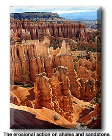
Geology
Sixty million years ago, sedimentary deposits in a large prehistoric
lake created the Claron formation, a combination of limestone, siltstone,
shale, sandstone and occasional conglomerate as well. Subsequent uplift
and faulting created the massive blocks we now call the Paunsagunt and
Aquarius Plateaus. Erosion caused the exposure of the Claron formation
atop of these plateaus,which continues to this day.
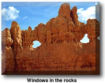
The uplifts and faulting formed blocks that streams carved into the
plateaus. The joint systems and cracks produced by the uplifting determine
the location of walls, arches, windows and natural bridges. The pinnacles
(hoodoos) are the result of differential weathering along vertical
fractures on these Claron beds, containing layers with varying degrees of
hardness. Most arches in the park are carved from the sandstone beds of
the Claron formation in much the same manner.
Some of the interesting geological formations in Bryce Canyon National
Park include:
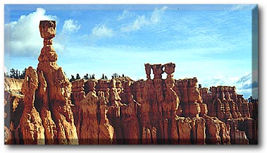
Sinking Ship: Visible from Fairyland Point.
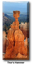
Thor's Hammer: Visible from Sunset Point.
Wall Street: Visible from Sunrise Point.
Silent City: Visible from Inspiration Point.
White Cliffs: Navajo Sandstone formation visible from Paria View.
Natural Bridge: Really an arch, visible from Natural Bridge turnout.
The Hunter: Hoodoo, with small trees on top visible from Aqua Canyon.
The Poodle: Hoodoo visible from Rainbow Point.
Top
Setting
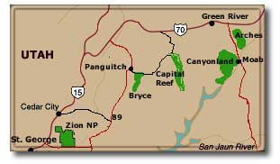
Bryce Canyon National Park is about 80
miles northeast of Zion National Park but is starkly different in climate,
topography, geology and scenery. Bryce sits atop the Paunsagunt Plateau of
southwestern Utah between the Markagunt Plateau to the west and Aquarius
Plateau to the east. At its widest point, it is about 5 miles east to west
and runs 20 miles north to south. Instead of looking up at sandstone
formations as at Zion, one is looking down along the Paunsagunt Fault onto
much different geological features, primarily hoodoos, formed from the
erosional action on shales and sandstone of the Claron formation.
At 8,000 feet where the visitor center is
located, it is 1,000 feet higher than Zion, with a cooler, moister
climate. Much of the area's precipitation comes as afternoon
thundershowers during mid to late summer. Spring and fall weather is
variable. Cold winter days are offset by high altitude sun and dry
climate. Winter nights are sub-freezing. During some winters, Alaskan cold
fronts descend on the Colorado Plateau bringing temperatures as low as 30
degrees below zero. The area can have significant snow October through
March; annual snowfall averages 100 inches.
The high altitude sun can burn in any season. Hats, long sleeves and
sunscreen are recommended all year.
| Bryce
Canyon National Park- Monthly
Climate Normals |
| |
Year |
Jan |
Feb |
Mar |
Apr |
May |
Jun |
Jul |
Aug |
Sep |
Oct |
Nov |
Dec |
| High
°F |
57 |
36 |
39 |
44 |
54 |
63 |
75 |
80 |
77 |
72 |
61 |
46 |
39 |
| Low
°F |
24 |
4 |
8 |
15 |
23 |
29 |
36 |
44 |
43 |
35 |
26 |
14 |
8 |
 |
| Avg.
°F |
40. |
20 |
23 |
29 |
38 |
46 |
55 |
62 |
60 |
72 |
43 |
30 |
23 |
Rain
|
9.5 |
0.7 |
0.5 |
0.7 |
0.6 |
0.7 |
0.4 |
0.1 |
1.4 |
1.1 |
1.0 |
0.6 |
0.8 |
Plan to spend from one to several days
depending on your personal interests. Because of the wide variety of
recreational opportunities on nearby private, state and other Federal
lands, you can easily plan an extended vacation in this area.Sight-seeing,
hiking, camping, backpacking, photography, horseback riding, bird watching
and other wildlife observation, star gazing, contemplation, relaxation.
Most visitors tour the main amphitheater
between Sunrise and Paria Viewpoints. Congestion in these areas creates
problems with off-trail use and destruction of vegetation. Use only
designated trails and exercise patience and care in all heavily congested
areas to protect park resources.
Picnicking
Picnic tables are provided at the
Whiteman Connecting Trailhead and at Rainbow Point at the far southern
extremity of the Park. Others are located at Sunset Point near the Lodge,
at Sunrise Point and near the visitor center. Picnic only in designated
areas.
Auto Touring
The 37-mile round-trip on the main park
road winds along the edge of the plateau, terminating at the south end of
the park. Return to the entrance via the same road. Spur roads and
pullouts offer opportunities for viewing and trailhead parking. Park speed
limits range from 25 to 35 mph and are strictly enforced.
In summer, parking at most viewpoints is extremely congested. Your best
chance of finding a parking space at Sunrise, Sunset, Inspiration, BRACE
and Paria Viewpoints is before 10:00 AM. and after 5:00 PM.
Because all of BRACE Canyon's viewpoints are east of the main park road,
it is recommended that you drive the 18 mile distance to the southern end
of the park, start with Rainbow Point, then stop at the remaining
viewpoints on your way back northward toward the park entrance. This will
help you to avoid making left turns in front of on-coming traffic.
Fairyland Point
Far northern area a mile east of the main road offers startling view
of Sinking Ship with the Aquarius Plateau and Navajo Mountain in the
distance.
Sunset, Sunrise, Paria Points
These 3 points ring Bryce Amphitheater, the largest amphitheater in
the park.
Paria View
Looks across hoodoos and an amphitheater carved by Yellow Creek. The
Aquarius Plateau and Paria River Valley are in the background.
Farview Point
Offers a panoramic view of nearby plateaus and mountains. The Kaibab
Plateau of the Grand Canyon North Rim is also visible far to the
southeast.
Natural Bridge
Is misnamed. It is really an arch.
Ponderosa Canyon
Displays multi-colored hoods with the Aquarius Plateau to the north.
Aqua Canyon
Offers a view of small trees growing atop the hoodoo known as The
Hunter.
Yovimpa Point
Provides a grand view of southern Utah and south into Arizona.
Rainbow Point
The park road ends here. On clear days one can see 90 miles south to
Arizona revealing the Kaibab Plateau of Grand Canyon's North Rim and
Navajo Mountain.
Biking
Biking is allowed only on paved roads in
the park. Biking on any trails or into the canyon is prohibited.
Hiking/Backpacking
The park has over 50 miles of hiking
trails.
Day Hikes
| Rim Trail between Sunrise
and Sunset Points, 1/2-mile (one way), is the easiest section of
the trail. Other sections of the Rim Trail (which extends 5.5 miles
between Fairyland and BRACE Points) have moderate terrain.
| | Fairyland Loop (8 miles round
trip)
| | Peekaboo Loop (4.8 miles
round trip)
| | Queen's Garden (1.5 miles
round trip)
| | Navajo Loop (1.5 miles round
trip) trails drop into the canyons on steep grades.
| | Peekaboo Loop Trail also
serves as a horse trail. |
Backcountry
| Under-the-Rim Trail extends
22 miles from BRACE Point to Rainbow Point and has 8 backcountry
campsites.
| | Riggs Spring Loop Trail runs
(8.8 miles round trip) from Rainbow Point and has 4 backcountry
sites. A $5 permit is required for overnight backcountry camping. |
Top
Horseback Riding
In spring, summer and fall, wranglers
lead horseback rides into BRACE Amphitheater along a dedicated horse trail
as well as on the Peekaboo Loop Trail. Contact one of the horse rental
providers listed below for details:
Canyon Trail Rides
P.O. Box 128
Tropic, UT 84776
435-679-8665 |
Red Rock Ride
P.O. Box 128
Tropic, UT 84776
435-679-8665 |
Scenic Rim Trail
Rides
P.O. Box 58
Tropic, UT 84776
435-679-8761; 800-679-5859 |
Boulder Mountain
Lodge
Junction Hwy. 12 & Burr Trail
Box 1397, Boulder, UT
800-556-3446; 435-335-7460; fax 435-335-7461 |
Escalante Scenic
Trail Rides
P.O. Box 275
Escalante, UT 84726
435-826-4630 |
Escalante Canyon
Outfitters
P.O. Box 1330
Escalante, UT 84726
435-335-7311 |
Boulder Mountain
Ranch
On Hells Backbone Road
Escalante, UT 84726
435-335-7480 |
|
|
Getting There
By Auto
Bryce Canyon National Park is 24 miles
southeast of Panguitch, Utah.
From north or south on U.S. 89,
turn east on Utah 12 (seven miles south of Panguitch, Utah) and travel
to the junction of Utah 12 and 63. Turn south (right) on Utah 63 and
travel three miles to reach the park entrance. (Utah 12 continues east
through the northern portion of the park.)
From the east, travel west on Utah 12 to the intersection of Utah
63. Turn south (left) to reach the park entrance.
|
Updated September, 2000

During the 80 miles drive from Kanab to Bryce Canyon we were a little fearful
the weather would be too stormy, but as it turned out to be excellent. Again Deb
and I really had a photo hey-day at Bryce Canyon.
After entering the park at the north end we drove 18 miles to Rainbow Point 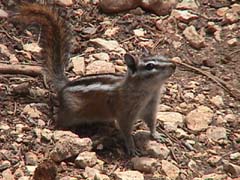 at
the southern end of the road. The vista point there was at an elevation over
9,000 feet. It was still cloudy and stormy and cool, but we had lunch in a
wooded area with several chipmunks eagerly awaiting the droppings we might leave
behind. at
the southern end of the road. The vista point there was at an elevation over
9,000 feet. It was still cloudy and stormy and cool, but we had lunch in a
wooded area with several chipmunks eagerly awaiting the droppings we might leave
behind.
There were still lots of clouds when we started taking pictures. They added
some to the scenery, but they were a little heavy and for a time threatened to
drop rain on us. They established a different mood for the canyon.
 The
vista point at the south end has a large pine grove and many small bushes. Some
of these were still in the midst of their spring bloom. This looks like
manzanita, but I believe it was something else. Alice is supposed to be the
wealth of knowledge on such matters but she wasn't much help in this case. The
vista point at the south end has a large pine grove and many small bushes. Some
of these were still in the midst of their spring bloom. This looks like
manzanita, but I believe it was something else. Alice is supposed to be the
wealth of knowledge on such matters but she wasn't much help in this case.
The clouds started thinning  and
the colors started coming out in the canyon walls. In the distance to the north
we could see the escarpments making up the edge of Bryce Canyon. There was lots
of photo opportunities to be checked. and
the colors started coming out in the canyon walls. In the distance to the north
we could see the escarpments making up the edge of Bryce Canyon. There was lots
of photo opportunities to be checked.
Bryce Canyon runs roughly north and south. You basically travel along its rim
from one end to the other, looking down into the canyon over the eroded spires
of sandstone and some shale. Those spires are called hoodoos.
There are some trails you can take down into the canyon. Most of them can be
done in a day, some in a couple of hours. The elevation is between 7,500 and
9,000 feet, so don't expect to run up and down the slopes.
There were many vista points  along
the road to the north. We stopped at every one available including some that
were not true observation points, simply wide places in the road we found along
the way. There were always new things to see and new views of things we had seen
before. With the sun going behind clouds from time to time the variation was
enhanced.Top along
the road to the north. We stopped at every one available including some that
were not true observation points, simply wide places in the road we found along
the way. There were always new things to see and new views of things we had seen
before. With the sun going behind clouds from time to time the variation was
enhanced.Top
Going back over the pictures, there are many that look alike. This is a
collection of 20 of the 140 photos I took. In addition I have two panoramic
views. I left out a lot of spectacular shots.
 There
a few local hoodoos that were even more colorful than usual. This red colored
formation was about 300 feet below the road. The zoom on my camera brought it
close enough to get the feel that some gnomes are marching across the canyon
floors. There
a few local hoodoos that were even more colorful than usual. This red colored
formation was about 300 feet below the road. The zoom on my camera brought it
close enough to get the feel that some gnomes are marching across the canyon
floors.
Occasionally the erosion creates an arch.  This
is one that is beginning. It will grow bigger and bigger until the harder top
rock falls away. These are nothing like what you see in the hard sandstone at
Arches National Park, but they are interesting. This
is one that is beginning. It will grow bigger and bigger until the harder top
rock falls away. These are nothing like what you see in the hard sandstone at
Arches National Park, but they are interesting.
 We
met several wildlife friends who visited with us as we took our pictures. They
all seemed to expect us to feed them. This crow was very interested in what we
had and then found a candy wrapper on the pavement. It was not afraid of us, but
was wary. It is sad that people persist in dropping their garbage along the way
for animals like this to find and devour. It definitely was not to his benefit. We
met several wildlife friends who visited with us as we took our pictures. They
all seemed to expect us to feed them. This crow was very interested in what we
had and then found a candy wrapper on the pavement. It was not afraid of us, but
was wary. It is sad that people persist in dropping their garbage along the way
for animals like this to find and devour. It definitely was not to his benefit.
Down in the canyon there were some wild formations. This
set of hoodoos looked like a castle. The clouds and sunshine played with it, and
we got several shots where it changed its appearance again and again. It was
probably over a mile away from the road, so it is much larger than it may appear
in this photo. This
set of hoodoos looked like a castle. The clouds and sunshine played with it, and
we got several shots where it changed its appearance again and again. It was
probably over a mile away from the road, so it is much larger than it may appear
in this photo.
Hard rock caps covers the softer material.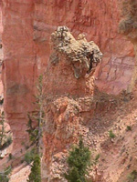 The caps protect the material underneath from erosion, leading to the high
spires. They estimate that the canyon has eroded away about 60 feet since it was
first visited in the mid-1800s. We don't have to worry a great deal about the
erosion. There are still miles of hills to be eroded away, producing an every
changing National treasure. Of course, they will have to tear out the road and
move it back from time to time.
The caps protect the material underneath from erosion, leading to the high
spires. They estimate that the canyon has eroded away about 60 feet since it was
first visited in the mid-1800s. We don't have to worry a great deal about the
erosion. There are still miles of hills to be eroded away, producing an every
changing National treasure. Of course, they will have to tear out the road and
move it back from time to time.
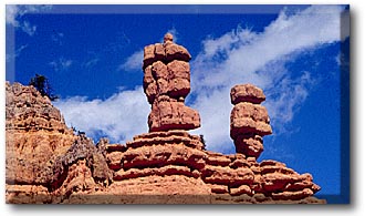
 There
were some formations that will fall in the next few years. This balanced rock is
a candidate for sooner rather than later. They tell us Bryce Canyon is eroding
at an average of six inches per year. In some ways that seems like a lot, but it
has taken over a million years to get where it is now. There
were some formations that will fall in the next few years. This balanced rock is
a candidate for sooner rather than later. They tell us Bryce Canyon is eroding
at an average of six inches per year. In some ways that seems like a lot, but it
has taken over a million years to get where it is now.
The clouds continued to hang around.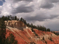 They
brought out some of the more interesting colors from time to time. This picture
provides a good view of the primary cap rock for the region. It is cracked along
the edge so that water seeps down and carries away the material from around the
spires that will develop in later years. They
brought out some of the more interesting colors from time to time. This picture
provides a good view of the primary cap rock for the region. It is cracked along
the edge so that water seeps down and carries away the material from around the
spires that will develop in later years.
 Here
we look south along the escarpment back towards Rainbow Point where we started
about noon. As you can see, there are places where the clouds are almost gone
and the sky is clear. Here
we look south along the escarpment back towards Rainbow Point where we started
about noon. As you can see, there are places where the clouds are almost gone
and the sky is clear.
Top
Further down the road we stopped to view Natural Bridge. A sign at the site made a point that this is an arch, not a natural bridge.
There is no stream flowing through it. It was named back before people got picky
about such things.
A sign at the site made a point that this is an arch, not a natural bridge.
There is no stream flowing through it. It was named back before people got picky
about such things.
But there is a big bully cut back into the hillside along side the road that
is the source for the runoff that is cutting this arch deeper and deeper.
 The
colors changed as the sun changed its angle. This pink cliff contrasted nicely
to the green hills in the distance. Further in the distance you can see even
more breaks where the erosion is building even more canyons. The
colors changed as the sun changed its angle. This pink cliff contrasted nicely
to the green hills in the distance. Further in the distance you can see even
more breaks where the erosion is building even more canyons.
Some cliffs showed the strata well. This photo shows the variations in colors of the formations. The whole of
southern Utah is underlaid by these formations. They produce some of the most
spectacular scenery found in the United States, if not the world.
This photo shows the variations in colors of the formations. The whole of
southern Utah is underlaid by these formations. They produce some of the most
spectacular scenery found in the United States, if not the world.
One of my toys is the PhotoVista program. It stitches digital photos together
into a panorama, adjusting the magnification and shades to match the
side-by-side shots almost seamlessly. It does this with photos I take without a
tripod.
 This
is a panoramic view from Bryce Point. It spans over 180 degrees of view, so it
takes a little getting used to. You can download the full image from the web,
but be sure you want to do it. The large version of this picture is 1.1Mbytes in
size.. This
is a panoramic view from Bryce Point. It spans over 180 degrees of view, so it
takes a little getting used to. You can download the full image from the web,
but be sure you want to do it. The large version of this picture is 1.1Mbytes in
size..
Around the observation points were the mamas and papas of wildlife.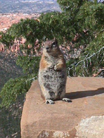 The signs all said do not feed the animals, but this one obviously was eating
something. She was quite willing to pose for me and several others. She was not
really happy when we did not pay off like she hoped.
The signs all said do not feed the animals, but this one obviously was eating
something. She was quite willing to pose for me and several others. She was not
really happy when we did not pay off like she hoped.
 We
drove on up to Sunset Point. There are a number of trails originating around
Sunset Point. You can walk down part way and then come back, or if you have the
time you can do a full circuit. Of course, it takes longer to come back than it
does to go down. We
drove on up to Sunset Point. There are a number of trails originating around
Sunset Point. You can walk down part way and then come back, or if you have the
time you can do a full circuit. Of course, it takes longer to come back than it
does to go down.
Be sure you have a good pair of shoes before you venture on the trails. They
are loose dirt and gravel, and you can slip. If a shower comes along while you
are on the trail, it can get muddy and slippery.
Deb made it part way down one of the trails.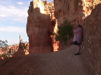 It was a little more steep than she wanted, so she rested against the up side
from time to time.
It was a little more steep than she wanted, so she rested against the up side
from time to time.
The colors become more intense as you go down the trails, especially as the
sun shines on the walls and reflects back and forth down into the depths. It is
something to see.
The park is installing a shuttle system. This may become the only way to see
Bryce in the future, at least during the busy season. The staging area is at the
north end of the road near Ruby's Inn.
Here is some miscellaneous information. The average rainfall is about 18
inches per year. In 1999 there were 1.7 million visitors, mostly between
mid-June and the first of September. There is a use fee for entering the park.
The area was first settled by Ebenezer Bryce who helped settle the area in 1875
to 1880. The nearest significant town is Tropic which sits at the bottom of the
escarpment.
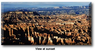
The sun was still high in the west when sunset began. The sun was at our back and the shadows built and stretched out across the
hoodoos and canyons.
The sun was at our back and the shadows built and stretched out across the
hoodoos and canyons.
 Slowly
but surely the shade enveloped the canyons. We did not have the time to stay
until the end -- it was 80 miles back to camp. So we left before the final show.
But we saw enough to gain an appreciation for the beautiul scenery at Bryce
Canyon. I believe we will go back some day and try out more of the trails. If we
take it easy, even us old foggies can make it up and down the sides of the
canyon. And the views from below should make it all worthwhile. Slowly
but surely the shade enveloped the canyons. We did not have the time to stay
until the end -- it was 80 miles back to camp. So we left before the final show.
But we saw enough to gain an appreciation for the beautiul scenery at Bryce
Canyon. I believe we will go back some day and try out more of the trails. If we
take it easy, even us old foggies can make it up and down the sides of the
canyon. And the views from below should make it all worthwhile.
Top |