Woke early. Granola for breakfast and coffee. Last leg
today, hump it to the top. Last night at dinner Randy said
we'll have no problem, as he'd made it to the top in 3
hours, once. So, though we would be gaining 3000 feet in
elevation, it should be a breeze. We went through all our
food stuffs and decided to keep only what we'd eat on the
way out. We dug a hole and dumped our excess food into it.
Some of it was freeze dried, so to protect any animal that
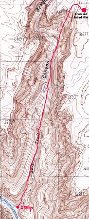
dug it up, I poured water on it to make it safe. NOTE: Last summer Mike, John and I took a trip out to the
Salt Canyon trailhead to scout the termination of this hike.
At that time, we hiked down about 1300 feet in about 1/2
mile. Very very steep. The first 3/4 up Salt Canyon was pretty uneventful. We
had passed serveral singular
petroglyphs and a rock pile
that was constructed one stone at a time as native americans
passed on the trail. When we had reached the spot we had descended to last
spring, things got interesting. On that trip we had picked
out a landmark to watch as we approached the top. We
named it the Spire, a solitary monolith that stands about 75
to 100 feet high. It was easily
visible and used it to guide our approach to the rim of the
canyon. We followed cairns that had us hugging the right
of the Spire and curling behind it. It led us into a steep
drainage. (At this point all the drainages were very
steep) At this point, we'd made our way up the left side of the
wash and it dead ended. John went ahead (up) to scout. Nada.
As he was coming back down he released a few rocks (we're
even!). At another point, we hit another place where we
couldn't advance. I scouted up to the left and recounted
that it was impassable. John said he'd like to take a look.
He called back that he'd found a way and for me to advance,
wash left. I again came to the ledge that I'd told John was
impassable and he'd already contoured around a vertical
section. But how?? He said to come ahead, that I could make
it, and that even if I fell, it'd only be a couple feet. I
could see him over the ledge, and passed him my camera. I
carry my camera in a large fanny pack in the front, and it
wouldn't be possible to hug the rock and wear the camera.
The ledge consisted of a strata that was about three to four
inches thick, that had eroded away. This
left a place to put my boots. The cliff I was to crawl along
looked about 20,000 feet down, but topped out around chin
height. This allowed me to reach out at neck height and look
for hand holds as I inched my way around toward John. I
don't think I'd have done it if it hadn't been for John
coaching me through it. It was a wild experience for me.
Following this, it was a short, safe scramble to the rim and
truck. It was now noon, 5 hours from our start. We got out the
extra water John brought and washed away the brackish water
we had to drink on the way up. Had lunch, bagels and peanut
butter, of course! Randy had said he'd made it to the top in
three hours once. I think he was in a helicopter! We made it to Williams by 5:00, just in time to check
into the motel and turn on the first San Francisco Giants
playoff game. It was a truly Great trip. We had many exciting
experiences. From the beginning, they just kept building and
got better with each day. I enjoyed the entire experience,
from pre-trip meetings with John, to the actual hike itself.
John did all the planning, from the permits to the shuttle
service to the route. Thanks John, I wouldn't have had this
experience without you.
Return to Table of
Contents ----- Go
To Day 7