As part of the
planning that went into this hike, we enlisted the services
of Carolyn Walton of Greenhound Shuttle Service that we met
early on the morning of September 30. Together we drove to
the trailhead of the Salt Trail on the Navaho Indian
Reservation, the ending point of our hike. Here we left our
vehicle and loaded ourselves and backpacks into Carolyn's
van and headed for the New Hance Trail trailhead on the
South Rim. Carolyn dropped
us off at the trailhead of the New Hance Trail at about 9:00
AM. Elevation: 7100'. River at the end of New Hance Trail is
2550'. We'll drop 4550' in 8.5 miles. The trailhead itself
at the rim of the canyon is about 1/4 mile from the road by
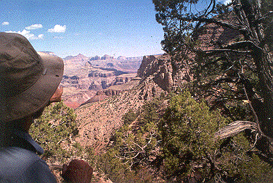
a well-traveled trail. Anxious to see the canyon, we walked
the short distance and stopped for breakfast. All of our
breakfasts consist of the small pint-sized baggies filled
with granola and three tablespoons of powdered milk. Just
add water to the baggie, stir and enjoy. The baggie is then
easily stored and you don't need a bowl! We began our
decent at 09:20. We had been down this trail in the spring
of 1999 and because we didn't need to scout the route and
the fact that there was just the 2 of us instead of 6 as on
the earlier hike, we made good time that first day. We had
monitored the weather in and around the canyon (as well as
water flows on the Colorado) leading up to the adventure and
knew it would be very warm. Because there is no reliable
water source along the New Hance Trail, I carried 5 liters
of water and Wayne carried 3. The hike down was enjoyable,
hot (90 degrees) and uneventful because we had the
confidence of "having been there before". I won't go into
the specifics of the trail because it has been documented
elsewhere but suffice to say, it is a rough trail that wears
you out. The map on the left shows the lower 2/3's of the
trail. Last year we found water where the trail meets the
floor of Red Canyon and we had stopped and soaked our feet
and heads in the cool stream.This time it was dry and we
just pushed on. On the way down, we were in sunlight for
most of the way and it was brutal. We were fully exposed
much of the time and there was no wind to cool us. I was
glad I carried 5 liters because I consumed 4 and pour the
contents of the fifth periodically on my head. Wayne wished
for an additional liter. Also next time Wayne said he would
carry a small water bottle that attaches to his belt and
transfer water to it from the larger bottles that he carried
in his backpack. He said it was a pain in the butt to either
drop his pack to get at his water or to bother me to get it
for him. Our lunches
were the same throughout the hike. Wayne had 1.5 bagels with
peanut butter for lunch and a small baggie of trail mix. I
had trail mix (granola, nuts, dried fruit), licorice (peach
flavored), meat sticks, bagels and peanut butter. I
discovered quickly that I had WAY too much food. Next time I
would not bring the licorice (it nearly liquefied in the
heat) or the meat sticks. I frequently offered a meat stick
to Wayne. He wisely refused. We arrived at
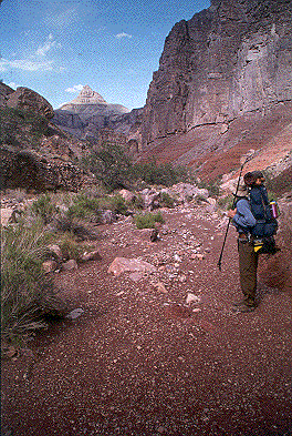
the River safe and uninjured. Part of the day's hike that I
enjoyed a lot is from where the trail makes its final entry
into Red Canyon to the River. From here down, about 1.5
miles, the trail stays in the wash and at this time of the
day is shaded. The going is mostly over low sloping bedrock
and gravel. The sides of the canyon are steep and canyon
widens as you descend. There are some boulders as large as
small houses in the wash and some brush too. All the while
you get the feeling that the river is just around the next
bend in the canyon. I think it's just wishful thinking
because, at this point in the trail, your legs are like
rubber bands. After the steep descent, it's all you can do
to lift one foot and put it in front of the other, though
It's a nice respite from the earlier downhill trudge. We met
no other hikers on the trail. We arrived at
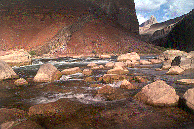
the Colorado River and Hance Rapids at about 3:20. It was
running blue and cool. We immediately dropped our pack and
went for a "swim." That evening we
met two hikers, Linay and Jan from Winslow and Portland.
They were leaving the following morning, up New Hance!! I
didn't envy them because they had a 4500 foot climb in 90
degree heat in full sun most of the way. They'd come down
Grandview trail to Horseshoe Mesa and Hance Creek.
We set up camp
in the acacia, same place as last year. I took a short nap
while John scouted around. I woke after about a half hour,
refreshed. Looking at the river, it seemed that there were
lots more rapids than last year. I'll have to check my
slides from that trip... Lots of dragonflies. Two sizes of
bats. Lots of Gray Jays on the way down. No (thieving)
Ring-tailed Cat this time. We topped off our water with the
filter pump I brought. This time, I brought a collapsible
plastic 5 gallon container. I filled it with river water and
carried it to the camp site and pumped from it. Was a lot
more comfortable than trying to balance on some rocks at the
edge of the river. John set up his stove and we dined on
some freeze dried something or other, followed by tea
(Thanks, John). That night we slept out under the stars.
What a sky! It was transparent. No twinkling. Was also new
moon, so it was pretty dark. We watched Cassiopeia and...I
went out like a light. Woke up during the night smelling
skunk, but didn't see it.
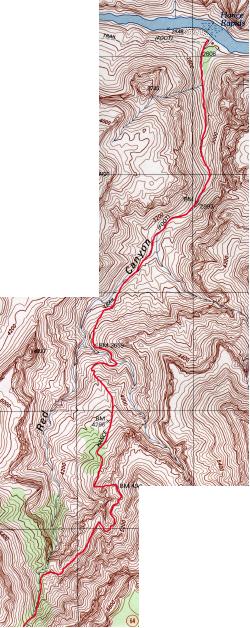 New
Hance Trail to Hance Rapids
New
Hance Trail to Hance Rapids