JD
![]()
February 2006
ONTARIO: A Place to Stand *
a geographic perspective
by Ravi Deshpande
|
When I say the words “Ontario geography”, I suspect nothing in particular jumps to the minds of most Canadians, much less those outside Canada. Some geographies have distinct personalities like some people: the loud and swaggering sea and mountain scapes of British Columbia do not need much introduction; the homey and pretty Prince Edward Island sits cloaked in green against the wind on its red windy cliffs and sweeping sea vistas. But like a shrinking wallflower at a party, the geography of Ontario is rich, subtle and cerebral and takes a little more coaxing to reveal itself. Ontario, only the second largest province in Canada, is equal in size to Spain and France combined. It contains freshwater lakes that together cover an area greater than all of Greece. Ontario contains extremes of geography which would normally be found across continents or countries, not provinces, and it contains within its borders geographic features which are known around the world. The province has three distinct geographic zones—the well known, fertile post-glaciation farmlands to the south, the equally well known Canadian Shield and a third: the roadless and unknown Hudson bay lowlands, comprising almost a third of the province, which drain into James and Hudson Bay. Like three different countries, each is distinct and has a transition zone which is sharply demarcated, both by topography and vegetation. To the observant traveler, there is little uncertainty that one is passing from one zone to another. Southern Ontario
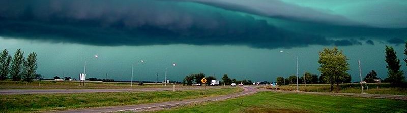
storm cloud over countryside near Guelph The business and human culture and consequently, the awareness, of our province’s terrain is so concentrated in the first zone that it would be easy to overlook criticism that Ontario’s geography is dull. On a recent visit to Kirkland Lake, I heard a precise description of how Northern Ontarians view the south: “fertile, prosperous and entirely corrupt”. I won't address the last item, but the first two are a direct result of the post- glaciation soil and so called “till”, a mixture of small stones and soil which was deposited around 15,000 years ago, creating a mild rolling landscape ideally suited to agriculture. Like a giant mortar and pestle, the receding glaciers ground the rich mix of minerals, limestone and sedimentary rocks that form the bedrock into some of the best farmland in the world, with rich black loam suitable for growing corn, tomatoes, tobacco, beans, and in the warmer areas, wine grapes and fruit. There are many apple orchards in southern Ontario, and the province rivals Quebec as a producer of maple syrup. With the rapid urbanization of southern Ontario, much of this farm land is being eaten up, causing the disappearance of these fertile farm fields, the small rural villages and the way of life that was associated with them. Having spent my first years as a child in rural Ontario, I remember the lovely little mixed farms that formed a checkerboard across southern Ontario, each square about a hundred acres in size and supporting a few cows, a hen house, a few acres of vegetables and a cash crop or two along with a place for the farmer’s hobby horses, lambs or pigs. Below southern Ontario, and reaching northward along its western flank, like a foundation, stand the deep blue, sea-like expanses called the Great Lakes. As a child, the word “lake” meant these vast oceans of fresh water, with long sandy beaches and dunes up to the horizon. Until I heard visitors from abroad exclaiming their surprise and delight at the size of these vast lacunae, I wasn't aware that throughout most of the world a lake is hardly more than a pond, measuring thousands of feet or at most a few miles. Some years ago I wondered if there is a binding force among the “Lakers”, those who live along the shores of these Great Lakes. There is a certain commonality shared by the cities of Cleveland, Chicago, Detroit, Rochester, Toronto and Hamilton and all the other communities that stand a short distance from one of the Lakes. Is it the smell of the Lakes, the perch or smelt fishing, the port history of the lake freighters? Or is it the changeable character of the lakes themselves, their sparkle in the summer, their angry storms, their cold, sullen winter demeanor? Whatever it is, growing up amongst them, I always associated pleasure and happiness with being close to Lake Erie or Lake Huron. Driving to the beach, my father would always point out the clearing landscape, and then suddenly, we would reach a rise in the road and break free to see the wide, unbridled vista of the lake open up before us. As seaside dwellers view the ocean, so do the Great Lakes take the place of the great mother ocean in the hearts of those in southern Ontario. There are two important—and interesting—exceptions to the rolling farmland of southern Ontario. The Niagara Escarpment is a large arc of 400-million-year-old limestone passing through southern Ontario, Michigan and New York State, forming abrupt cliffs rising 400 feet above the otherwise gentle farmland. It was formed when Canada was a tropical country. The mind can hardly grasp the span of time that has passed since it was deposited: six times the length of time between the present and the age of the dinosaurs, and predating all the recent glaciation events in Southern Ontario by 300-fold. Its hard limestone and dolomite rock is not easily broken down, and it lay buried for hundreds of millions of years, before it was exposed by the incessant march and recession of the glaciers, eroding and scouring away all the softer rock around it. The most famous point on the escarpment is Niagara Falls itself, one of the great natural wonders of the world. The happy intersection of two features has combined to create this stirring natural spectacle: Niagara Falls sits where the mighty Niagara River carries the entire volume of the St. Lawrence Seaway, draining Lake Erie into Lake Ontario and spilling over the Niagara escarpment, whose hard, tough dolomite cap stone has allowed a dramatic vertical drop of some 160 feet to form. Without the escarpment, what we now see as Niagara Falls would've been just a river. I recall, as a high school student traveling north of London, on a quiet country road, seeing the strata that recorded the remarkable history of southern Ontario. On top, deposited 10,000 years ago—just a tiny heartbeat of geologic time ago—was the glacial till consisting of unremarkable dirt and gravel-like stones ground and scraped across the land during the last glacial recession. And below was the hard, veined limestone, from the Silurian era, over 400 million years old. As a result, fossils abound in Southwestern Ontario, and amongst the gravel in an ordinary driveway, a child on his way to school can easily find a perfectly preserved brachiopod, a reminder of the long-dead, petrified bodies of crustaceans which swam when Ontario was in an equatorial latitude. Less drama attends the area of unbroken flatness west of London. This is considered part of the Midwest prairie, part of the same area that extends to Iowa and the Dakotas, and up into Manitoba and Saskatchewan. It accounts for the lack of any hills west of London, all the way to Windsor; the roads straight as a ruler, unvarying in elevation. Having lived in West Lorne, a tiny village which sits smack in the middle of this featureless plain, I spent my time dreaming about exotic landscapes that I could only experience through a Viewmaster… Canadian Shield It's not surprising that almost no paintings of southern Ontario exist. But the Canadian Shield has been immortalized in paintings by painters who range from Cornelius Kreighoff in the 18th century to the famous Group of Seven. These images of wind-swept white pines and granite are emblematic of the Canadian Shield. Strewn with tiny lakes, it was formed when heavy glaciers dragged across the Shield, a vast plain of solid igneous rock, gouging out the notches that have since filled with water to become a thousand tiny lakes. For most Ontarians the southern lip of the Shield is cottage country and the sight of a pine or fir tree against the blue sky, outcrops of pink granite, the sounds of splashing and swimming and the drone of outboard motors are essential ingredients of summer. The Shield is remarkable for its antiquity: only in Australia have older rocks been found, and the 2-billion-year-old granite and basalt of the Canadian Shield was formed when the earth was one half its current age, before life itself appeared on our planet. It is a beautiful, twisted landscape, both wild and welcoming because of its low hills, small, accessible lakes and coniferous forests. Driving north from Toronto, the land changes abruptly north of Barrie, from the full bloom of waving cornfields and straight rows of crops. By the time one reaches North Bay, the transformation is complete and the farmlands of the south are a distant memory. The air is purer and drier, and the pines, spruce and fir can be seen barely clinging to rugged granite faces as the land climbs higher and higher, reaching the highest point in Ontario, the Ishpatina Ridge in Temagami. The Shield brims with minerals, nickel, copper … and gold. At Hemlo, on Lake Superior, one of the largest discoveries of gold in the 20th century was made in the late 80’s. It is these minerals which have allowed isolated towns like Kirkland Lake or Timmins to rise like islands in a vast expanse of boreal forest. Hudson Bay Lowlands The Hudson bay lowlands are an area that few Ontarians have any direct experience of. Almost all of it lies north of the populated areas of the province. Although there are many ports on our great oceans of the interior, the Great Lakes, these lowlands reach the only true sea coasts we have. The lowlands hardly enter the perceptions and awareness of even well traveled Ontarians because of their remoteness and the absence of roads. Only tiny bush planes buzzing like mosquitoes over a giant’s face can penetrate this remote region. The oldest port in Ontario (and indeed one of the oldest in Canada) is not on the Great Lakes at all, but on James Bay: Moosonee, from where the Hudson's Bay company sent its ships to bring back furs from the new colony. Nature heaves to a stop in this polar north. Gone are the fertile fields to the south and the boreal forests of the great Shield. The vegetation becomes scrub-like, with stunted dwarf trees. The boggy, rocky plain lacks any topography as it slopes and drains a vast area of land into the cold waters of Hudson Bay. While the lowlands may play no great part in the commerce, industry or recreation of our province, they form an essential part of the Ontarian and Canadian consciousness. I think we all live in this country with the notion, usually unspoken, that above us lies a great, virgin wilderness, haunted by the timber wolf, the polar bear and the caribou. We do not go there and may never go there, but there's comfort in knowing that there still exists in the world, and in our country, a wilderness that represents a pure and clear space unsullied by the affairs of men. I did not realize how conspicuous this notion was till I lived in the United States. Their wilderness is not like our wilderness, bounded as it is on all sides by more cities and roads. Whenever you enter an unpopulated area in the U.S., you will always emerge on the other side, to see a city, people, airports, roads, an ocean—or Canada. Our north is deep and unknown…we rarely enter, and there is nothing on the other side but snow and ice—and more emptiness. Far too often, modern society distances itself from its natural environment. Many urban Ontarians have little awareness of, and I fear, little interest in the varied geography that is contained within the spacious boundaries of their province. I have a book on the parks of Ontario, and one of the writers asks: “how will a young child, who has never seen the snow on the boughs of a balsam tree in February, or a seen the wiggle of a tadpole in a spring stream, become a conscientious and sympathetic friend of the wilderness?” We must be aware of our geography, its meaning and its history, to love it for its own sake, quite apart from any commercial or economic value it may have. * an old children’s song about Ontario which begins: “Give us a place to stand...” see also |