Jayant Deshpande
![]()
June 2005
ONTARIO—a landscape remembered
|
At first glance
Ontario seems like a monotonous
flatland that seems to stretch without limit if one stands on one of the
countless corn or tobacco fields in the southwestern peninsular region. That's
where I grew up, beginning in the village of West Lorne—southwest of
London—where our family arrived and settled in August 1962. My mother, brother,
sister and I had just emigrated from India, and my father (Appa) had come from Prince
Rupert, British Columbia after spending a year there. Soon after this, my father
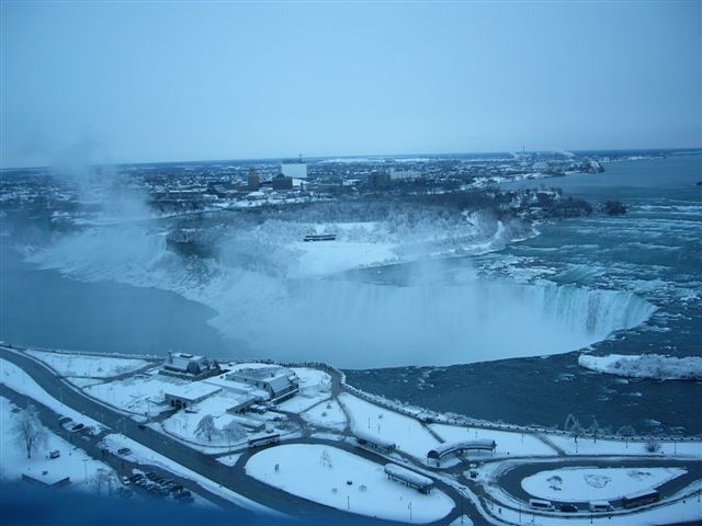
took us all to Niagara Falls on Thanksgiving weekend in the blue-white '56 Chevy he'd just
bought. Niagara Falls is an awesome sight for anyone who sets eyes upon it,
especially the Horseshoe Falls on the Canadian side. The fall colors heightened
the experience.
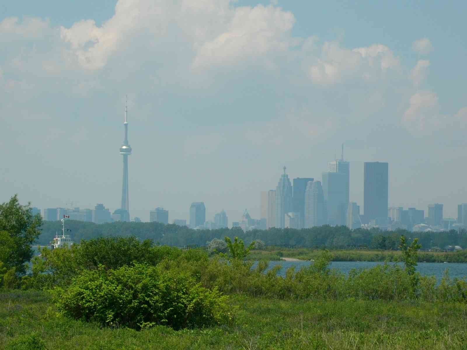
(click for larger image) Years later, when I was in high school, I learned that the 165-foot drop at the Falls was due to the extensive Niagara Escarpment (beginning in Wisconsin)—the Niagara River, through which Lake Erie flows into Lake Ontario, has cut a gorge through the scarp, resulting in the Falls. From Lake Huron onwards there's a drop in elevation with each lake—that's why the area east of Hamilton and north of Lake Ontario is a relative lowland. As one travels east of Woodstock towards Hamilton, the descent due to the Escarpment is dramatic. Hamilton sits both on the scarp and down below on the lakefront. During 1981 I'd spent a lot of time in this area, visiting Stelco, Dofasco and the Canada Centre for Inland Waters. Whenever I drove between London and Toronto I could see the partially exposed rocky face of the Escarpment at the Kelso Conservation Area near Milton; a more continuous view of the scarp face can be had as one drives on the QEW from St. Catharines to Fort Erie on the Niagara Peninsula. And so I became aware that there was some relief, some topography in this part of Canada after all. In 1965, on a trip to Tobermory and Manitoulin Island I saw the southern fringes of the vast and ancient Canadian Shield for the first time, where the terrain vaguely resembles some aspects of the Deccan Plateau in Western India where I'm now settled. However, each has a markedly different geologic history: the Deccan had undergone a volcanic upheaval, whereas the present landscape of the Shield was formed largely by glacial activity during the last ice age. Some of the oldest rocks on our planet can be found in the Shield. Being a rock hound in those days, I'd greedily collect any out-of-the-ordinary rocks I could lay my hands on, and overload the car's trunk, much to my mother's dismay—she was seldom moved by the non-living! To the east the main highway from Toronto to Montreal cuts through many rocky outcrops and hilly ground, especially in the stretch that begins around Belleville and goes well past Kingston. Scenic in its own way. Whenever I'd go anywhere with even the slightest relief, I'd be excited by the prospect, whether it be the Appalachians, or the rocky area west of Sudbury, especially around Espanola, north of Manitoulin Island. The terrain is rugged and and gets rockier, dotted with a myriad tiny lakes, as you go west and northwest along the shores of Lake Superior into Canadian Shield country. In the summer of 1974, on a bus journey from Toronto to Vancouver, I passed through Sault-Ste-Marie, Wawa, Thunder Bay and Fort Frances—it was the only time I saw the northern part of Ontario, at least the part that hugs Lake Superior and borders on Minnesota. The whole region is sparsely inhabited and has a wild and desolate beauty. The fact remains that most of Ontario's landmass sits above the 49th parallel, but nearly all of its people live below it. Just south of Collingwood, at Blue Mountain, the elevation is about 1800, the same as Pune, Maharashtra, where I now live. But the highest elevation in Ontario is only around 2300 feet, at a place called Ishpatina Ridge, between Sudbury and Timmins. The highest point in Pune, atop Vetal Hill is also about this height—but this is a good 3000 feet lower than the highest point in Maharashtra: Kalsubai, rising to 5300 feet, near the city of Nasik, about a hundred miles from here. However, these comparisons are misleading. Western Maharashtra is criss-crossed by numerous ranges of the Sahyadri mountains, which in turn are part of the longer Western Ghat system in India that runs parallel to the Arabian Sea coast. In Ontario hilly relief is occasional, like an afterthought—the flat expanses characterize it more than anything else. There's hardly any rolling land of the kind one sees in the downs of southern England. But a host of small fresh water lakes dot most of its landscape like sparkling blue jewels, save the large and clumsy fingers of land that form the southwestern peninsula. This peninsular expanse derives its grandeur from the truly magnificent Great Lakes that surround it. Throughout Ontario one is never far from a nourishing body of water, and the green cover is generous: deciduous woods in the south and dense evergreen forests in the north. Traveling along any of the highways, byways or gravel roads in southern Ontario one is ever conscious of lush green fields and wooded areas on all sides up to the horizon. Toronto, by far the largest urban area in this
province, has a topography
all its own, sitting as it does on the north shore of Lake Ontario. The Don Valley is by far its most salient feature, but in general
one encounters gentle rises, slopes and ravines all over the city: they owe their origin to
glacial movements. (In fact, traces of this geology, i.e., mounds, ridges and
hillocks due to moraine deposits, can be seen throughout southern
Ontario). The Scarborough bluffs along the Lake Ontario shore to the southeast
are another geologic feature that brings variety to Toronto's physical
landscape. A
hazy view of the CN Tower & the Toronto skyline. The London area also has an interesting topography, especially in the southwest part. At Reservoir Park, on Commissioner's Road West, there's a lookout point from which great views can be had of central and north London. This is where the road winds down to Baseline Road. And as you drive further west, towards Komoka, you sense the swell of the slightly rolling land that gives the area some character. Southern Ontario has a soft, welcoming, embracing kind of environment—largely wooded and relatively moist in the geographic sense—that is congenial, without extremes in climate or landscape which in other parts of Canada, including Ontario's northern reaches, make the land inhospitable, or at least inaccessible, to some extent. This is a brief account of what I recall about Ontario, landscape-wise, from my teen years and youth. It includes a few details, though, that I became aware of later on. Also, I've mainly described what can be seen clearly during the non-winter seasons. Snow cover hides important detail and tends to make all landscapes look much the same, unless of course they're interrupted by significant relief. It's no wonder that Ontarians are eager to go west to the Rockies or east to the Appalachians to enjoy the sight of hills and mountain ranges, whether up close or in the distance. Jayant Deshpande see also
ONTARIO—A
Place To Stand: |