GEOGRAPHY
The Mascareignes Archipel is made up of Mauritius, Reunion island and Rodrigues. It obtained its name after the dutch navigator Pero Mascarenhas who was one of the first europeans to indicate its existence at the begining of the 16th century.
Mauritius, independent state, is situated at 890 KM east of Madagascar, between 19üŗ50' and 20üŗ32' of south latitude and 57üŗ18' and 57üŗ46' of East Longtitude. Reunion, french island, is 200 km south west and Rodridues, a dependence of Mauritius is 600 km to the East North East.
Of volcanic origin, these islands separated by sea pits of 4000 metres depth, have emerged from the abysses as a result of gigantic underwater volcanic eruptions that happened thousands of kilometres to the east of the continental block made up by Africa and Madagascar.
Regarding the age of these different islands, it is known that Mauritius has started to emerge some 8 million years ago whereas Reunion emerged some 5 million years later. Even if the plateau under the lagoon of wide area surrounding Rodrigues may be much more ancient than the island, the island is only 1.5 million years old
Regarding the topography of Mauritius, it has an area of 1860 Km2 and is made up of a central plateau gradually rising towards the south west where it reaches its highest point at 800 metres with the Piton de la Rivière Noire. This plateau is still surrounded with what is remaining from the primary crater in the form of a chain of mountains that are not very high (Moka, Corps de Garde, Pieter Both) and some isolated peaks (Piton du Milieu, Motte à Thérèse).
ü@
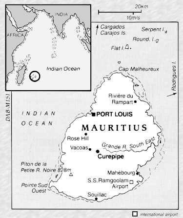
Map of Mauritius
ü@
ü@