|
About the Streetcar History of Minneapolis
and the Falls of Saint Anthony
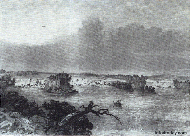
Falls of Saint Anthony, Seth Eastman, 1830, Minneapolis Public
Library and Information Center
The Mississippi River travels southward from
its source at Lake Itasca, in northern
Minnesota,
down to the present site of Minneapolis.
It is here that the river tumbles over
a
ledge of Plattville limestone, eventually
falling a total of about 50 feet. Today, this same Plattville limestone is
seen in both the façade of the
Pillsbury
A Mill, built next to the falls in
1881,
and in the foundations of some of the
oldest
homes. Today, this same Plattville limestone is
seen in both the façade of the
Pillsbury
A Mill, built next to the falls in
1881,
and in the foundations of some of the
oldest
homes.
An engraving of a painting by Seth
Eastman
(above) shows the Falls of Saint Anthony
as they looked prior to the arrival
of Europeans.
Father Hennepin named the falls for
his patron
saint, Saint Anthony of Padua, on his
visit
to the falls in 1680.
The first permanent bridge to span
the Mississippi
(anywhere along its entire length)
was located
near the falls in 1856. Also in 1856,
the
University of Minnesota was moved downstream
to its present location and the town
of Minneapolis
was incorporated.
Originally, the town on the east side of
the falls was known as Saint Anthony Falls.
Its name was shortened and was incorpoated
as Saint Anthony in the year 1855. The town
that sprang up on the west side of the falls
was Minneapolis. These two towns merged in
1872 to create the City of Minneapolis.
Saint Anthony, after 1872, became known as
the East Side. The areas within the East
Side were further delimited by Hennepin Avenue
(the major avenue that traverses the East
Side) into Southeast Minneapolis on the south
side of Hennepin Avenue, and into Northeast
"Nordeast" Minneapolis on the north side of Hennepin
Avenue. East Side street names had "NE"
or "SE" appended as suffixes.
Although the water power was used for
lumber
and flour milling, making Minneapolis
the
"Mill City," the falls also energized the first hydroelectric plant
in North America beginning in 1882.
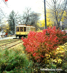
Electricity
from the falls powered the Minneapolis streetcar system.
This inexpensive and convenient mode of transportation
fostered housing development in newer "streetcar"
neighborhoods at the edges of the city. In
addition, many of the schools and neighborhood
shopping areas sprang up due to the availability
and proximity of nearby streetcar service.
As homes were built, housing styles were
chosen that reflected the tastes of the individual
owers and builders. The architectural designs
also reflected current trends. Streetcar
neighborhoods, some located in Northeast
Minneapolis, were built for working-class
people, and the housing in these areas exhibited
the owners' practicality. This practicality
is still seen in some of the beautful Craftsman
bungalows of Northeast.
Many Northeast residents were newly-arrived
immigrants from Europe.They needed to remember
the names of the United States presidents to pass the test for citizenship. So, the
street names in Northeast were arranged,
using the names of the presidents, from Washington
Street to Coolidge Street. (Note: William Henry Harrison's street is now Central Avenue. Benjamin Harrison's
street is Benjamin Street.).
Streetcars were instrumental in the growth
of suburbs, such as Morningside, Robbinsdale,
and Columbia Heights. In the case of Morningside, now part of Edina,
there was an influx of an upscale citizenry
of Downtown employees. These suburbanites
commuted by rail daily. As a result, the
buildable lots in Morningside often ended
up being a big larger than elsewhere to reflect
the growing, middle-class prosperity.
The streets in the Edina area were occasionally
named for local landowners, such as Brown
and Grimes. Both of these Edina residents
had their names associated with steetcar
stops (Browndale and Grimes) on the line
that ran along West 44th Street from Lake
Harriet to the Blake School, Downtown Hopkins,
and Excelsior.
Until 1931, electrically-powered streetcars
were carring passengers from Stillwater,
on the Wisconsin state line, as far west
as Lake Minnetonka. Streetcars had made suburban
life feasible, but the Great Depression years
called for a cutback in some of the outlying
areas. As a result, services to destinations
such as Excelsior, Deephaven, and Stillwater
ended.
Streetcar service continued in Minneapolis
until June,1954. Its end did not come
due
to lack of popularity or competition
from
automobiles, as some have said, but
as a
result of an organized divestiture
of the
assets and deferred maintenance. This
ransacking
by unsavory characters left the finest
streetcar
system in American in shambles.
Today, despite the demise of the rail
system,
the streetcar neighborhoods continue
to thrive.

Copyright, © 2005, by Dave Malas
|