|
Islamic Republic of Iran is the vast plateau country,
crossroads between the Middle East and the rest of Asia, a land where history
and ancient civilisations are steeped in mystery and legend.Ranking as the fifteenth populous country in the world, Iran with a total
population of 58,500,000 demonstrated an annual growth of 3.6% during late 1980s.
Encompassing a 1,648195 Sq. km area and strategically located in the middle east
region, Iran is situated both in the northern hemisphere and east of Greenwich
meridian on 25-40 degree lat and 43-63 degree long.
 iran's
geography iran's
geography
-
Location:
Middle East, bordering the Gulf of Oman, the Persian Gulf, and the Caspian Sea, between Iraq and Pakistan
-
Geographic coordinates:
32 00 N , 53 00 E
-
Map references:
Middle East
-
Area:
total:
1.648 million sq km
land: 1.636 million sq km
water: 12,000 sq km
-
Land boundaries:
total: 5,440 km
border
countries: Afghanistan 936 km, Armenia 35 km, Azerbaijan-proper 432
km,
Azerbaijan-Naxcivan exclave 179 km, Iraq 1,458 km, Pakistan 909 km, Turkey 499
km, Turkmenistan 992 km.
-
Coastline:
2,440 km; note - Iran also borders the Caspian Sea (740
km)
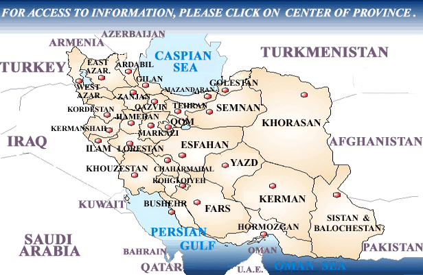
Islamic Republic of Iran is officially divided into
28 provinces, 195 cities, 500 districts and also the city of Tehran and its
suburbs, with over 10 million inhabitants, constitute the capital.The
following is a list of major cities and their distances from the capital:
|
Kerman: 1064
km |
Mashhad: 924
km |
Kermanshah: 520
km |
|
Ahwaz: 881 km |
Dezfool: 747
km |
Tabriz: 597
km |
|
Sanandaj: 512
km |
Esfahan: 414
km |
Anzali: 363
km |
|
Zahedan: 1605
km |
Bandar Abbas: 1443
km |
Bushehr: 1217
km |
|
Rasht: 325 km |
Arak: 302 km |
Babol: 211
km |
|
Qom: 135 km |
|
|
|
|