<BGSOUND SRC="bwv812.mid">
O1
17
The megalithic tombs of the Netherlands, Province of Overijssel
The megalithic tombs of the Netherlands, Province of Friesland
The megalithic tombs of the Netherlands, Province of Drenthe
�2001 Wim Dekker, Haren
Hunebed D54 bij Havelte (Havelterberg), gemeente De Wolden / Großsteingrab D54 bei Havelte, Gemeinde De Wolden / Allée couverte D54 chez Havelte, commune de De Wolden / Tumba megalítica D54 cerca de Havelte, municipio de De Wolden
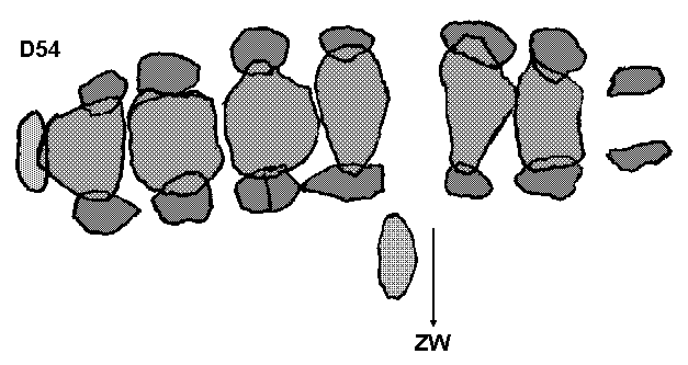
Map of the megalithic tomb Drenthe 54 near Havelte (Havelterberg, the more eastern of the two), municipality of De Wolden, cadastral section Havelte I nr. 578. Owner: State of the Netherlands, acquired from the Markgenoten van Havelte on 27th and 28th of April 1871; 25 stones, deviation 70�30�, condition July 2001.
The megalithic tombs of the Netherlands, Province of Friesland
Verdwenen hunebed F1 bij Mirns (Rijsterbos), gemeente Gaasterland / Verschwundenes Großsteingrab F1 bei Mirns, Gemeinde Gaasterland / Allée couverte F1 disparue chez Mirns, commune de Gaasterland / Tumba megalítica desaparecida F1 cerca de Mirns, municipio de Gaasterland
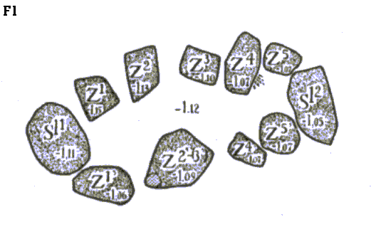
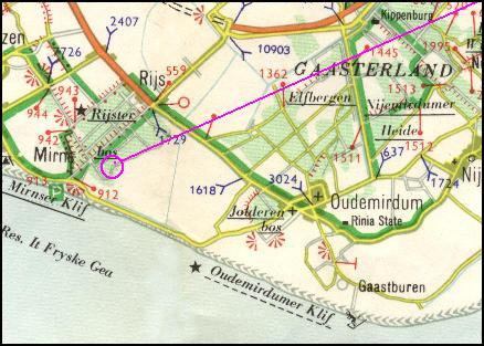
Map of the disappeared megalithic tomb (stone cist) Friesland 1 near Mirns (Rijsterbos), municipality of Gaasterland. The traces of the orthostats are shown, as explored in 1922 at 1.12 m below the surface. Z denotes the former orthostats, Sl the kerb stones. Also investigated in 1849 after its discovery.
The megalithic tombs of the Netherlands, Province of Overijssel
Verdwenen Hunebed O1 bij Eese (De Eese), gemeente Steenwijk / Verschwundenes Großsteingrab O1 bei Eese, Gemeinde Steenwijk / Allée couverte disparue O1 chez Eese, commune de Steenwijk / Tumba megalítica desaparecida O1 cerca de Eese, municipio de Steenwijk
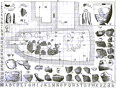
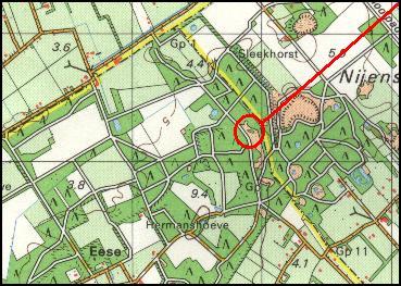
Map and found artefacts of the disappeared megalithic tomb Overijssel 1 near Eese (De Eese), municipality of Steenwijk. Shown on the map are the ground traces of the up-right standing stones (orthostats) and the pieces of pots and spear heads found in 1918. Also investigated in 1840.
O1
17
Location of tomb D54 near Havelterberg / Lage des Grabes D54 bei Havelterberg / Ligging van het graf D54 bij Havelterberg / Position de la tombe D54 chez Havelterberg / Posición de la tumba D54 cerca de Havelterberg
Location of the disappeared stone cist F1 near Mirns / Lage des verschwundenes Steinkistengrab F1 bei Mirns / Ligging van de verdwenen steenkist F1 bij Mirns / Position du coffre de pierre disparu F1 chez Mirns / Posición del cofre sepulcral de piedra desaparecido F1 cerca de Mirns
Location of the disappeared tomb O1 near Eese / Lage des verschwundenes Grabes O1 bei Eese / Ligging van het verdwenen hunebed O1 bij Eese / Position de la tombe disparue O1 chez Eese / Posición de la tumba desaparecida  O1 cerca de Eese
Location of the disappeared tomb O2 near Mander / Lage des verschwundenes Großsteingrab O2 bei Mander / Ligging van het verdwenen hunebed O2 bij Mander / Position de la tombe disparue O2 chez Mander / Posición de la tumba desaparecida O2 cerca de Mander
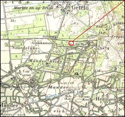
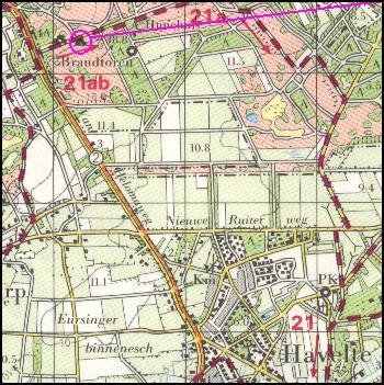
Map of the location of the disappeared megalithic tomb Overijssel 2 near Mander (Manderheide), municipality of Tubbergen, topographic coordinates 28F 253.85 / 497.55, last investigated in 1957.
  
  
Back to the home page
Next page
One page back
E-mail me
Back to the home page
Next page
One page back
E-mail me
Drenthe
Groningen
Friesland and Overijssel
Niedersachsen
Schleswig-Holstein
Mecklenburg-Vorpommern
Danmark
Utrecht
Ground traces of O2 / Grondsporen van O2 / Bodenspuren O2 / Traces du sol O2
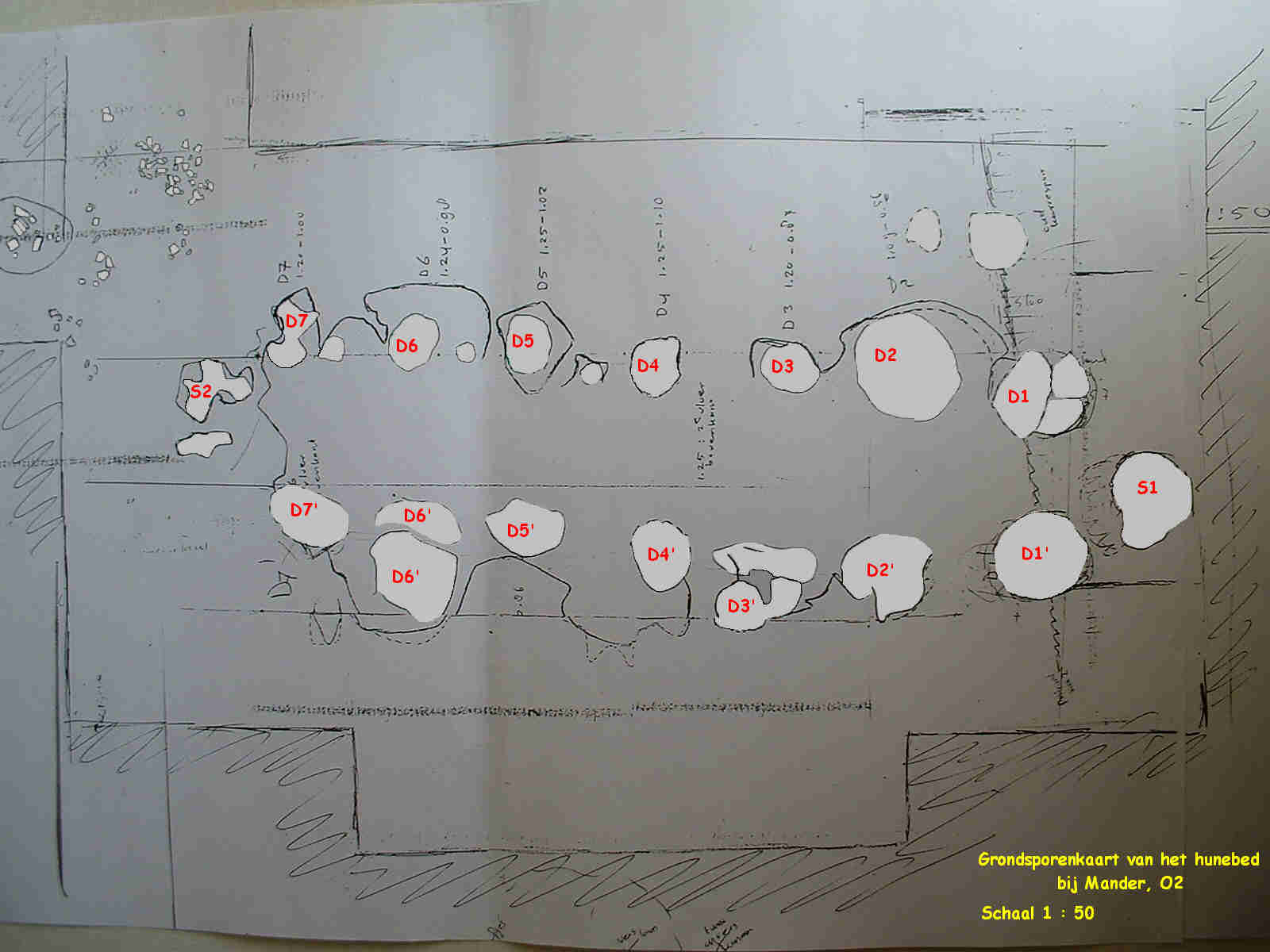
Grondsporenkaart van het hunebed O2 van J.N. Lanting van het Biologisch-Archeologisch Instituut in Groningen
Hosted by www.Geocities.ws

1