<BGSOUND SRC="bwv812.mid">
8
The megalithic tombs of the Netherlands, Province of Drenthe
�2001 Wim Dekker, Haren
Hunebedden D21+D22 bij Bronneger, gemeente Borger / Großsteingräber D21+D22 bei Bronneger, Gemeinde Borger / Allées couvertes D21+D22 chez Bronneger, commune de Borger / Tumbas megalíticas D21 y D22 cerca de Bronneger, municipio de Borger
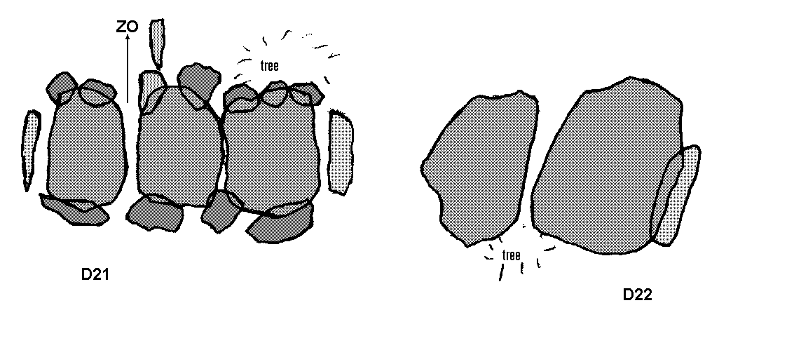
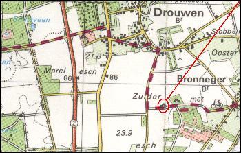
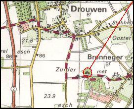
Map of the megalithic tombs Drenthe 21 and 22 near Bronneger (Zuider es, Kerkweg, the more southwestern and more northeastern of the two), municipality Borger, cadastral section G nr. 1632. Owner: State of the Netherlands, acquired from B. Luting on 22nd of December 1870; 13 and 7 stones, deviation D21 141�30�, D22 113�30�, condition July 2001.
Hunebedden D23+D24 bij Bronneger (Zuider es), gemeente Borger / Großsteingräber D23+D24 bei Bronneger, Gemeinde Borger / Allées couvertes D23+D24 chez Bronneger, commune de Borger / Tumbas megalíticas D23 y D24 cerca de Bronneger, municipio de Borger
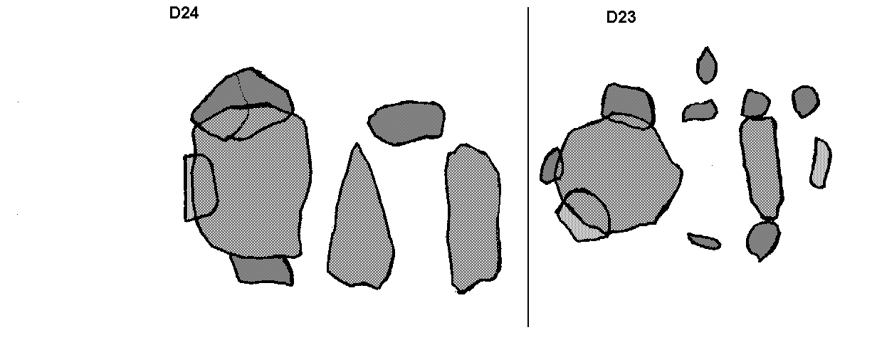
Map of the megalithic tombs Drenthe 23 and 24, near Bronneger (Zuider es, the most northern and southwestern of the three), municipality of Borger, cadastral section G nr. 1626 and 1627. Owner: State of the Netherlands, acquired from J. Oosting and J. Stoving at Bronneger on 1st of July 1871; 7 and 10 stones (1918), deviation D23 112�30�, D24 113�30�, condition July 2001.
Hunebed D25 bij Bronneger (Zuider es), gemeente Borger / Großsteingrab D25 bei Bronneger, Gemeinde Borger / Allée couverte D25 chez Bronneger, commune de Borger / Tumba megalítica D25 cerca de Bronneger, municipio de Borger
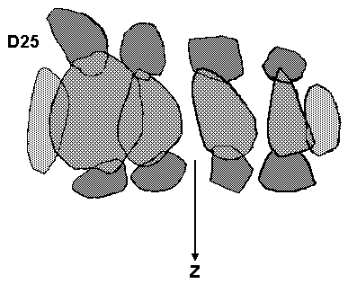
Map of the megalithic tomb Drenthe 25 near Bronneger (Zuider es, the most southeastern of the three), municipality of Borger, cadastral section G nr. 1628. Owner: State of the Netherlands, still on the name of Jantien Heling, acquired on 1st of July 1871; 14 stones, deviation 89�, condition July 2001.
Hunebed D26 bij Drouwen (Drouwenerveld, boswachterij Borger vak 63), gemeente Borger / Großsteingrab D26 bei Drouwen, Gemeinde Borger / Allée couverte D26 chez Drouwen, commune de Borger / Tumba megalítica D26 cerca de Drouwen, municipio de Borger
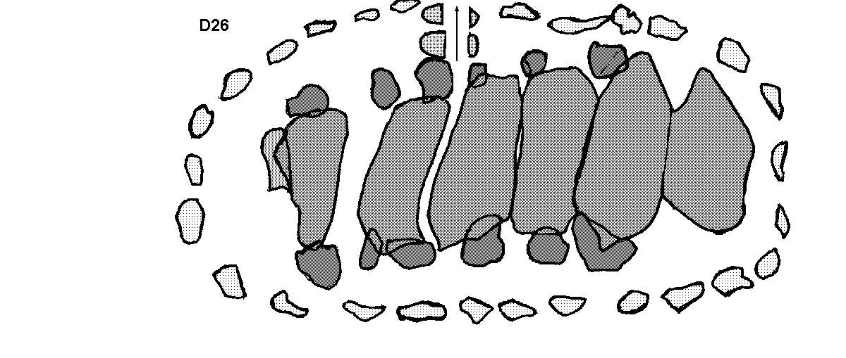
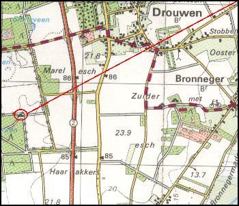
Map of the megalithic tomb Drenthe 26 near Drouwen (Boswachterij Borger vak 63), municipality of Borger, cadastral section G nr. 1591. Owner: State of the Netherlands acquired from J. Meursing c.s. at Nieuw-Buinen, K. Dilling and W.S. Dilling at Bronneger on 29th of March 1871; 32 stones, deviation 114�, condition July 2001.
8
Location of the tombs D21 and D22 near Bronneger / Lage der Gräber D21 und D22 bei Bronneger / Ligging van de graven D21 en D22 bij Bronneger / Position des tombes D21 et D22 chez Bronneger / Posición de las tumbas D21 y D22 cerca de Bronneger
Location of the tombs D23, D24, and D25 near Bronneger / Lage der Gräber D23, D24 und D25 bei Bronneger / Ligging van de graven D23, D24 en D25 bij Bronneger / Position des tombes D23, D24 et D25 chez Bronneger / Posición de las tumbas D23, D24 y D25 cerca de Bronneger
Location of tomb D26 near Drouwen (Drouwenerveld) / Lage des Grabes D26 bei Drouwen / Ligging van het graf D26 bij Drouwen / Position de la tombe D26 chez Drouwen / Posición de la tumba D26 cerca de Drouwen
Back to the home page
Next page
One page back
E-mail me
Back to the home page
Next page
One page back
E-mail me
Drenthe
Groningen
Friesland and Overijssel
Niedersachsen
Schleswig-Holstein
Mecklenburg-Vorpommern
Danmark
Utrecht
Hosted by www.Geocities.ws

1