 |
| Projects |
| Reef Environmental Education Foundation |
| This is the first time to knowledge that an RAFS-AA expedition has carried out a project for REEF, one that I hope will be continued for years to come on further expeditions not only to Belize but around the world too. Along with gathering valuable data, exped divers will be learning the intricate art of marine life recognition! |
| REEF's mission is to educate and enlist divers in the conservation of marine habitats and it is primarily accomplished through its Fish Survey Project. The Project was developed in 1990 with support from The Nature Conservancy (TNC) and guidance by the Southeast Fisheries Science Center of the National Marine Fisheries Service (NMFS). The REEF Fish Survey Project allows volunteer SCUBA divers and snorkelers to collect and report information on marine fish populations. The data is collected using a standardised method and is housed in a publicly-accessible database on REEF's Website. The data is used by a variety of resource agencies and researchers. |
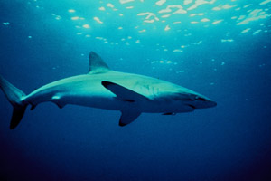
| To collect data for the Project, Ex Mayan Reef personnel will employ the Roving Diver Technique (RDT), a visual survey method specifically designed for volunteer data. The only materials needed are an underwater slate/wetnotes, a pencil and a good reference guide. During RDT surveys, divers swim freely throughout a dive site and record every observed fish species that can be positively identified, un-identified fish may be recorded on film/video and identified post dive.. The search for fish begins as soon as the diver enters the water. The goal is to find as many species as possible so divers are encouraged to look under ledges and up in the water column. Any sea turtle species seen during the dive should also be marked.
At the conclusion of each survey, each recorded species is assigned one of four abundance categories based on how many were seen throughout the dive; single (1), few (2-10), many (11-100), and abundant (>100). |
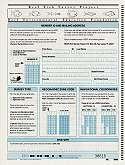
| Each surveyor records the species data along with survey time, depth, temperature, and other environmental information, on a REEF scantron form specific for the region the survey was conducted in, the location of the survey is recorded using the common dive site name and a REEF Geographic Zone Code. The diver can then submit their data into the REEF database using his/her unique REEF Member ID number. Visit REEF's website for further information on their variety of projects and the ways that divers can help. |
 |
 |
 |
 |