| Kirkcudbrightshire |
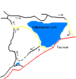
| Start at the west side of Clatteringshaws GR 535752. Go over the stile onto the forest track and follow this for 3km. The next section descends toward Black Loch and is rough but great fun. Just before Black Loch cross Tonderghie Burn and climb the overgrown track up to the forest road. Go right on the forest track over Poultrybuie Hill and Munwhal, then the fast descent to the minor road. If you prefer the short route then return to the start by the minor road. The longer route goes north past Craigencallie house and crosses the Black water of Dee after 2 km. Follow the forest road on the north side of Clatteringshaws to the main A712. Return by the main road stopping for refreshments at the tea room and museum |
| Clatteringshaws and the Old Edinburgh road Landranger 77 Route in brief 18km, 150m climb and descent or 27km, 200m climb and descent with a tea room on route |
 |
| Durisdeer. Map landranger 78 Start Durisdeer MR 893036 Parking in Durisdeer Local interest - Queensberry Aisle, church dates from 1699 and noted for its elaborate monument by Van Nost. Three routes well mapped out and covering a good mix of down hill and forest track. |
| The Buckland, Balmae & Whinnieliggate These tours have always been popular with locals. Views across the shore, easy-going sections, quiet woodlands, trickling burns, steady climbs, and downhill runs: these routes combine all the elements for short rides of between 5 and 11 miles. From Kirkcudbright, follow the A 711 south towards Dundrennan, past Sandside to Mutehill. Between these two groups of dwellings are a couple of roadside seats, with views across the Lake, and down to Ross Island at the mouth of Kirkcudbright Bay. At Mutehill, either take the easy-going minor road, to the right along the shore for Balmae, or carry on along the A 711 for � mile, turning into the minor road on the left, for the Buckland road. |
| Half Marathon. (The Dhoon, Twynholm & Tongland). 5 to 13 miles Follow the A 755 towards Gatehouse, crossing Kirkcudbright Bridge over the tidal river Dee just above the Harbour. Carry on past the Creamery and in � mile turn left along the B727 towards Borgue, passing The Stell (a small hamlet), Gibb Hill sawmill and Seaward caravan park. The road runs along the shore, there is no footpath, and it can be busy at times. Just before The Dhoon car park, at Nun Mill Bridge junction, take a sharp right turn and follow a minor road back to the A755. The Dhoon can be visited for a picnic/paddle/swim/toilet. |
| Around Loch Ken. 26 or 41 miles Loch Ken, created by the Galloway Hydro Electric Scheme, is 9 miles long, and has become a local scenic/recreational resource. Take time to linger awhile in picturesque New Galloway. From Kirkcudbright, cycle to Laurieston by A762 some 9� miles. Alternatively, transport cycles to Laurieston, and make a circular trip from there. From Laurieston (pub), head north through the village along the A762 towards New Galloway. The road is usually quiet and easily graded through trees and farmland; there are glimpses of Woodhall Loch on the left. |
| Borgue and Knockbrex. 18 miles This round trip visits several popular places on the region's 200 mile dramatic coastline. Along the route, of 18 miles, are rolling hills and acres of sky. Take the A755 towards Gatehouse, crossing Kirkcudbright Bridge over the tidal river Dee just above the Harbour |
| Gatehouse of Fleet & Laurieston. 28 miles From the town follow the A 755 towards Gatehouse, crossing Kirkcudbright Bridge over the tidal river Dee (just above the Harbour) and passing the timber houses. (The A755 is part of the National Cycle Network). Continue to Minto, Barharrow and beyond, through farming landscape to the A75 road. |
| Castle Douglas and Threave Gardens 20 miles From the town follow the A711 towards Castle Douglas, crossing Tongland Bridge over the tidal river Dee. In � mile, just past Tongland Power Station, turn right down to Old Tongland Bridge and follow this quiet undulating minor road to Rhonehouse (6� miles). At the cross roads in the village, carry straight on. Within � mile, turn right down a minor road passing Kelton Hill Farm and up a short rise. From the top of the rise, near a cottage, there is a good view north to the Galloway Hills. The descent is by the boundary of Threave Gardens (NTS), to a junction (to join the National Cycle Route 7), to the right of the entrance to the Gardens. |
| Urr Valley & Solway Coast 36 miles From the town follow the A711 towards Castle Douglas, crossing Tongland Bridge over the tidal river Dee. In � mile, just past Tongland Power Station, turn right down to Old Tongland Bridge and follow this quiet undulating minor road to Rhonehouse (6� miles). At the cross roads in the village, carry straight on. Within � mile, turn right down a minor road passing Kelton Hill Farm and up a short rise. From the top of the rise, near a cottage, there is a good view north to the Galloway Hills. The descent is by the boundary of Threave Gardens (NTS), to a junction (to join the National Cycle Route 7), to the right of the entrance to the Gardens. |
| To PAGE 2 |
 |