| Leave Durisdeer in a SW direction. At the cemetery go east up Glenaggart (steep) past the bothy to Blackhill Moss. Take the upper track and follow the Glen down to Garroch Water and the tarmac road. Go west (right) over Cample Water (4km) and right to Morton Castle. Follow minor tarmac roads back to Durisdeer. |
| Durisdeer |
| Route 1 |
| Route2 Distance 27 km. Strenuous, 2km carry/push. Go north east from Durisdeer along the roman road to the A702. The ascent on the Roman road is not hugely steep but it is continuous and although the surface is fair the climb is strenuous. The descent to the A702 is rutted and hence tends to be slower than might be hoped. Join the A702 and head north about 3km. After crossing Potrenick burn on the A702 follow the Southern Upland Way over Portail Water by the footbridge and along the rough track into the forest to the west of Pin Stane hill. A short steep section leads to the forest track. Going south the forest track climbs gently to open ground and then descends to the tarmac road by Daer reservoir. Travel south to the end of the tarmac and follow the pleasant track from Kirkhope past Daerhead to Thick Cleuch Moss where there is an alternative track leading up Sheil Dod. |
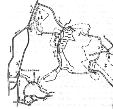 |
| This track is loose and steep and not a good ascent although it does go across the tops of Wedder law, Blackgrain shoulder and down to Glenaggart near Durisdeer. Continue up the nonexistent path shown on the map over Thick Cleuch Moss pushing carrying for 1.5 km. but with a bit of a view as a reward at the top. The descent from here is partly rideable through heather and then along the narrow track beside the burn. A bit of skill means this part can be enjoyed. A better track is reached and leads past Blackhill Moss to the bothy at the top of Glenaggart. The last section of the route is a fast exciting descent down Glenaggart to Durisdeer. |
| Route 3 45km, 800m climb 2km push/carry, very strenuous, great views. Start as route 1 but fork very steeply uphill after 1km up onto the side of Blackgrain Shoulder. Follow this track (intermittent) marked by posts where it disappears, over Blackgrain shoulder, to Wedder Law, Shiel Dod and then descend to the track by Thick Cleuch. Cycle past Daerhead and after about 1/2 km north go right (east) across rough ground between Lamb hill and Over Law to Crook Burn, where a track is found (2km part push/carry). Continue east on the track 3km and turn sharp left into the forest before Blairmark, passing to the south of Hangingshaw Hill. Go right and then left over Craig Hill. Follow the Southern Upland Way to the north end of Daer Reservoir and rejoin the tarmac road. Follow the tarmac to the A702. There is then the option of continuing on the A702and minor roads or cycling back over the roman road to Durisdeer. The A702 is a welcome free wheel, the roman road is a 90m climb and fast descent to Durisdeer |
 |