| Ayrshire |
| Fairlie moor, Kaim and Caldron hills. Landranger 63 Route 1, 17km 300m climb. Route 2, 12km 200m climb, 3/4 km uphill carry, technical descent. Interest - Kaim hill millstone quarry |
| Route 1 Parking is available just beyond the trees after the first cattle grid. Go down hill 30m and turn off just right (north) before the trees on to the track. Follow the track for 2km go through a gate, then left through another gate (20m) then right (west) along the wall past the cup and ring marked stone to a gate into the woods. Follow this tack then single track beside the burn for � km, cross the fence, burn and gate into a sloping field. Cross the field going north, at the trees look for a slight gap about 30m from the corner of the field, go over the fence through the gap and cycle down into Fairlie Glen stream (or fall into it). Cross the stream up a few meteres to a track & turn right, go lOOm downhill and through the gate in the wall to the right and follow the rough track 1 km and then the tarmac track uphill 2km to Fairlieward, go down hill (left) for 2.5km to the main road (A760). At the main road go left and left again at the tee junction (A78). Go downhill to the marina (1km) leave the main road and follow the footpath under the railway to the left of the marina entrance, go left immediately and follow the shore front and sea wall to Fairlie. Cycle through Fairlie and pick up the cycle track on the west side of the main road. At the turn of to Dalry cross the main road and climb uphill back to the start. |
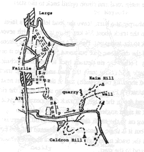 |
Route 2 Cycle on the tarmac road uphill after 1km near the highest point the road bends sharply right at a burn, leave the road left past a barrier on to a faint track, climb � km to a gate. Go through the gate and continue on the track about 3/4 km. there is a rise at the highest point of the track go over this heading east and follow the boggy track to the trig point. Descend by reverse route almost to the gate but do not go through it, instead follow the line of the dry stone dyke but about 50-lOOm above it on a sheep track, down to the south end of the millstone quarry. Follow the singletrack back to the road (technical descent). Go left uphill past the previous turn off, to the cattle grid (2km) leave the road and follow the track down to the sheds below Caldron bill. Follow the track and shooting butts (push) and at the high point next to a butt go north to the summit of Caldron bill (mainly push/carry). |
| From the trig point go north along the ridge of Caldron Hill, look out for a faint singletrack at the second dip in the ridge, the track disappears but cycle through the heather to two prominent rocks. Look out for wooden stakes marking the easiest route. Cross a track at right angles and after about 20 meters an overgrown track can be seen, follow it to the left contouring on to the south side of Glentane Hill. There is much deep heather and it is not easy to keep to the track, but it is there. Descend from Glentane hill and turn right along beside the dry stone dike, after a short descent the track turns right and contours above Glenburn reservoir over the burn and back to the tarmac road. Descend to the start |
| Ballantrae, Berneraird and Arecleoch forest Route in brief Distance 45km, climb 900m, 2km carry, fast descents, great view, map landranger 76 A good mixed ride with some major climbs and therefore downhills as well!!! great countryside and not to busy most days. |
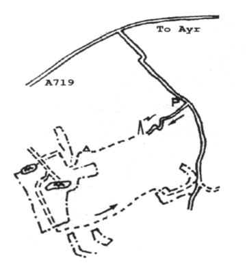
| Brown Carrick Hill Landranger 70 Route in brief 9km, 120m climb, good view. The route starts near the highest point on the minor road over Carrick hill 3 km south west of Ayr (GR 279165). Park near the tarmac track that leads up to the communications masts. Cycle up past the masts leaving the road to pass on the south side (left). Keep high and use the stile to cross the electric fence about 200 m beyond the masts. Go to the right of the small hill to find a faint track which leads to the top of Brown Carrick Hill. Pass the triangulation pillar and descend to the corner of the trees to where there is a gate. Go through the ride, turn right and go into the field. Turn left and follow the edge of the field to a good track (1/2km), go uphill through the gate and just before the loch fork right. Follow this rough track 1 km to a fence at the edge of the moor .At the fence turn left over short heather for 200m, then through a gate and back on to smoother ground. Go right to the edge of the moor and then left beside the fence. Follow the fence on the moor side for about 1 1/2 km past a farm building and up to some sheep pens. After the sheep pens go through the gate in the fence on the right and follow the line of the fence down to the tarmac road. Turn left and climb back to the start. |
 |
| Dalblair and Corsencon Hill Landranger 71 30km, 450m climb, 1km push. Park on the minor road before Dalblair (GR 640190), accessed from the A70 east of Cumnock. Cross the bridge over Glenmuir Water and after lOOm turn left uphill, take the right fork after 1 km and continue 5km up passed High Dalblair to Glenmuirshaw. |
 |