| Corsencon |
| Route 1 30km, 450m climb, 1km push. Park on the minor road before Dalblair (GR 640190), accessed from the A70 east of Cumnock. Cross the bridge over Glenmuir Water and after lOOm turn left uphill, take the right fork after 1 km and continue 5km up passed High Dalblair to Glenmuirshaw. Follow shepherds track over Connor Hill 2km, turn right onto the track and contour along Pepper Hill into the forest. 1km turn right 1/2km left, 1/2km right, 4 km to Fingland (GR 753176) and the tarmac road. Follow tarmac for 2km and join a track straight on at a sharp left bend (ie continue SW at GR 745165). Descend to Vennel and Kirkland. Cycle to the main road, turn right and after 200m turn off right over the rail bridge. Go uphill 4km on tarmac and then 3km on track to Craigshiel ruin. Continue along the track to the north east of Craigdullyeart Hill (GR658160) . Go through the old mine workings at the end of the track and head for the line of trees where a shepherds track can be followed back down to Dalblair. |
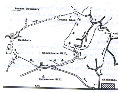 |
| Route 2 21km, 300m climb, 200m push, 200m uphill carry. Start at the north side of Corsencon Hill accessed from New Cuninock from the A76. Follow the NE track for 4km passed the ruin of Lethans and Clocklowie. At the track end push and carry across the forest ride to the track on the side of Auchtitench Hill. Go right (east) and after 1 1/2 km go right, 1/2 km left, 2km leads to route 1, go right, 1km right again and down to Fingland (GR 753176). Return to Corsencon Hill as route 1. |
 |
| Dalblair and Corsencon Hill Landranger 71 |
 |