How
to Travel in Pakistan:
Travel Internal
AIR: Most domestic services are operated by PIA. Other airlines
are Aero Asia and Shaheen. There are many daily flights from Karachi
to Lahore, Rawalpindi and other commercial centres. Air transport is
the quickest and most efficient means of travel.
Departure tax: Rs20 for internal flights. RIVER: Traffic along
the Indus River is almost exclusively commercial and many goods are
carried to Punjab and the north.
RAIL: A legacy of British rule is an extensive rail network,
based on the main line from Karachi to Lahore, Rawalpindi and Peshawar,
which has several daytime and overnight trains. Most other routes have
several daily trains. Even first-class compartments can be hot and crowded.
Travel in air-conditioned coaches is advised, as are reservations on
long-distance journeys and overnight service. Children under 3 years
of age travel free. Children aged 3-11 years pay half fare. Pakistan
Railways offer concessions for tourists (on presentation of a certificate
issued by PTDC), excluding Indian nationals traveling by rail. A discount
of 25% is offered to individuals and groups, and 50% for students. Vehicles
owned by foreign tourists or hired locally are also eligible to 25%
discount in freight charges when transported by rail. Details are available
from railway offices in Pakistan.
Approximate rail times: Karachi to Lahore is 16 hours, to Rawalpindi
is 28 hours and to Peshawar is 32 hours; and Lahore to Rawalpindi is
6 hours.
ROAD: Traffic drives on the left. The highway network between
cities is well made and maintained.
Bus: Regular services run between most towns and villages. Lahore-
Rawalpindi-Peshawarhas an hourly service. Air-conditioned coaches/buses
are recommended for long distances. Advance booking is advised.
Car hire: Available in major cities as well as at Karachi, Lahore
and Rawalpindi airports. Most hotels can book cars for guests.
Documentation: An International Driving Permit will be issued
on presentation of visitor's national driving licence.
URBAN: Extensive bus and minibus services operate in Lahore,
Karachi and other towns, although services can be crowded.
Taxi: Reasonably priced and widely available, they are by far
the most efficient means of urban travel. Note that they may not operate
after sunset during Ramadan.
Auto-rickshaws are also available.
Travel International
AIR:
Pakistan's national airline is Pakistan International Airlines (PK),
linking Pakistan with 47 destinations around the world.
Approximate flight times:
From Karachi to London is 11 hours 50 minutes, to Los Angeles is 22
hours 30 minutes, to New Yorkis 21 hours 40 minutes, to Riyadh is 3
hours 35 minutes and to Singapore is 6 hours 55 minutes.
International airports:
Karachi (KHI) (Civil), 12km (8 miles) northeast of the city (travel
time - 25 minutes). Good airport facilities exist, including duty-free
shops, bar/restaurant, post office, bank and shops. Coaches to the city
meet all arrivals. A bus runs from dusk to dawn every 30 minutes. Taxi
services to the city are available.
Lahore (LHE), 11km (7 miles) southeast of the city (travel time - 20
minutes). Airport facilities include car hire, bank, restaurant and
shops. Coaches leave every 20 minutes for the city. Buses go every 10
minutes. Taxi services to the city are also available.
Islamabad (ISB) (International), 15km (9 miles) east of the city (travel
time - 20 minutes). There are full duty-free facilities. Coach and taxi
services to the city are available.
Peshawar (PEW), 4km (2.5 miles) from the city (travel time - 10 minutes).
Full bus and taxi services to the city are available.
Departure tax:
Rs400 for passengers traveling first class, Rs300 for club class and
Rs200 for economy class. There is also an additional Foreign Travel
Tax of Rs700 on tickets issued within Pakistan. Transit passengers and
children under two years of age are exempt.
SEA:
The major port is Karachi (Kemari). There are a number of shipping lines
serving Karachi from Europe. It is both Pakistan's and Afghanistan's
port for goods, together with Port Qasim.
RAIL:
The only rail link to India is a train from Lahore to Amritsar which
leaves daily at 1100. Passengers have to be at the station by 0900 for
customs and immigration procedures. A rail link also extends over the
Iranian border to Zahedan; the Express train leaves every Friday at
1050; and the Passenger train, which travels as far as Taftan, leaves
every Tuesday at 1045 from Quetta.
ROAD:
Road links from China, Iran, India and Afghanistan. The main road link
is between Karachi and Lahore. There is a road from Kabul (Afghanistan)
to Rawalpindi. Another road runs from Karachi to Quetta and to the border
with Iran. Visitors exiting Pakistan by land routes are subject to a
road toll of Rs2.
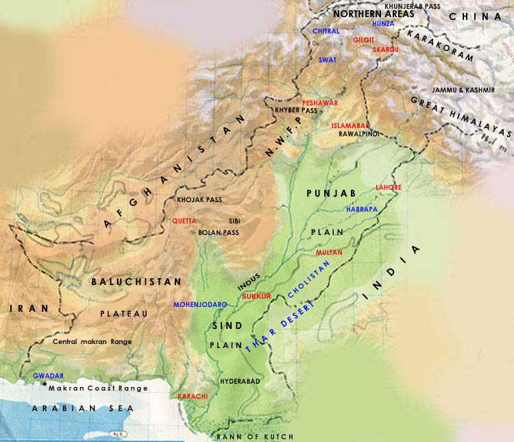
Mountain Tourism In Pakistan:
General
mountaineering and trekking in 1974 and since then a sufficient number
of expeditions come to Karakoram every year. A Pak-Japan joint expedition
took the first Japanese mountaineer along with the first Pakistani mountaineer
Mr. Ashraf Aman to the K-2 peak in 1977. They successfully scaled K-2.
This mountain has since been scaled by many climbers via all of its
sides and slopes. Mr. Nazir Sabir accompanying another Pakistani expedition
in 1981 successfully went for the first ascent of the most difficult
west ridge of K-2. Then in 1995, Mr. Rajab shah and Mr.Mehreban Shah
had the honor to become the first Pakistani pair to put their feet on
top of K-2 in 1995. To date so many mountaineers hailing from various
countries has scaled K2. They are among the world famous and prominent
mountaineers such as Rein Hold Messener etc. number of expeditions approaching
Karakoram every year average to 55. A sufficient number of foreign as
well as Pakistani mountaineers have so far scaled other high peaks of
Karakoram range, still there are so many other towering peaks yet remain
unscaled looking for a challenge from the daring ones.
Important Tracks
One of the prominent treks is known as Baltoro trek ending up at Concordia.
All the glaciers coming from K-2, broad peak and Gasherbrum-iv join
at Concordia flow downward to Paiju peak like a grand trunk road. This
is unique and one cannot see four 8000m summits in a small radius like
this anywhere else in the world. These include K-2, Broad peak, Gasherbrum-I
and Gasherbrum-II. Besides these 8000m gigantic peaks on this trek one
can cherish the scenes of Mesherbrum, Muztang towers, Chogolisa, Baltoro
cathedrals and different other summits.
Other well known treks
include Biafo Hisper trek, Nanga Parbat trek, Rakaposhi, Trichmir trek
and large number of other trekking routes.
Access to the Area and
Facilities for The Adventuring Tourist
Before Pakistan independence northern areas used to be approached via
Sringar Kashmir valley. The pioneers in the field of adventure exploration
made several days journey for our Bombay seaport of India to reach Srinagar.
From there they used to reach the upper portions of Baltoro glacier
and other areas in at least 40 days. Of course, in post independence
days access to these are improved significantly and first of all an
airport was constructed at Skardu and then a jeep road linking northern
areas with Rawalpindi was developed via Chilas and Kaghan valley. In
the mid fifties construction of the great Karakoram highway chasing
the old silk route was completed with assistance and collaboration of
great friends of Pakistan Peoples republic of China in 1978 giving an
all duty metalled land connection between Islamabad and Gilgit. It is
about 853 kms long and runs between Hassanabdal and Kunjerab pass. The
truckable between Gilgit and Skardu was at last completed in 1982. Meanwhile
a jeepable track between Skardu and Shigar has also been completed and
extended to Astore, thus cutting the trekking time to
K2
Now a days, there is only a day's jeep journey from Skardu to Astore,
and another 9 day trek till K-2 basecamp. Islamabad is serving as the
hub For the Northern areas where as Peshawar continues to serve as the
base to Chitral, Islamabad is also linked to Skardu by air with daily
flight of Boeing and Fokker flights to Gilgit. Any way these flights
operate only in clear weather. Spreading north from the Arabian Sea,
the plains of Pakistan end up in lush green valleys of Dir, Swat and
Kaghan. Then lie the grand
valleys of Chitral, Gilgit, Hunza and Baltistan. These valleys along
with a mountain range separate the two river systems draining from these
valleys. A chain of mountains form one of the sharpest cultural lines
in the world; the cultural boundary between Pakistan and central Asian
republic. Still towards north the Karakoram and the Hindukush ranges
form the western stretch of the Himalayas. Pakistan northern valleys
with scattered population, demonstrate the variety one could expect
of a boundary zone. Baltistan exhibit an affiliation with Tibet. As
a matter of fact, its language is a dialect of ancient Tibetan and several
remnants of Tibetan culture can still be noticed here. Shina is the
major language in the Gilgit region Visibly Gilgit most important contribution
to the area is the typical cap worn by the people in the most parts
of northern Pakistan. To the north famous Hunza continues its fame as
one of the great mountain societies of the globe Burushaski being its
It language as its origin continues to be mysterious. As Chitral to
the west, likewise Hunza demonstrates its rather old link with CA (Central
Asia) as a result of lying side by side of the caravan routes that stretched
towards south from its
mountain passes Kafir valley of Birir, Rambur and Bamburet are lying
with in the boundaries of Chitral. Presence of Kafirs infidels in a
notion almost Muslims is a unique phenomena. They have got their own
specific beliefs, traditions, and customs and art species. The landscape
in these areas is rightly called as a mountain desert. Heavy snowfall
isolates the valley from the rest of the world for almost six months.
Temperature usually goes beyond 100 degrees (F) in the summer. While
in Skardu one abruptly faces Juxta (position of sand hill and snow capped
mountains).
All the above mention valleys are the real source of becoming Pakistan
true heaven for trekkers. Pakistan is a house of Five 8000m summits
out of 14 in the
world. K-2 the second highest peak also exists here, we are also blessed
with gigantic glaciers namely Baltoro, Biafo and Hisper out of the polar
region. There are yet different areas in Pakistan still to be discovered.
Of course this fresh and clean landscape is looking to explored.
Mountain Sports
Rock Climbing
The towering
mountains of Northern areas and Chitral host fantastic areas varying
from moderate to high altitude rock climbing throughout their length
and breath. Although some fine rock climbing areas exist in other parts
of the country ranging from hill of Peshawar to Margalla hills near
Islamabad, to the mountains of Suleman, Pub, Kirther and Makran. While
these hills provide smaller rock pitches with steep slopes quite high
and steep ledges are located only in the Karakoram.
Ice Climbing
The high
mountain of northern areas and Chitral have different ice climbing sites
with easy approached from the road heads being a winter sport exclusively
it is another mountain sport event which is nonprevalent in the country
except that it is a part of mountaineering. It is also because it is
restricted to the far fling areas of the northern Pakistan.
Skiing and Snowboarding
There
are numerous areas in the northern Pakistan i.e. in the towering mountains
of the northern and Chitral as well as in the lower regions of swat
and Kaghan which have the potential to be developed as ski and snow
boarding sites. There are so many places and possibilities at hand for
cross-country skiing.
There are so many places
and possibilities at hand for cross-country skiing in the Northern areas
as well as in Chitral, Kaghan and Swat, with chemical reaction (precipitation)
and piling up of snow in areas except for northern areas is too high.
Skiing has been introduced and commenced late in Pakistan. Naltar near
Gilgit, Burail Pass area and Ratu, near Astore, District Gilgit are
presently best skiing sites available in the country. Of course, there
are a number of new and beginners standard slopes available at Malam
Jabba and a site with improper facilities at Ayubia in Murree hills
near Islamabad. Skiing on commercial basis has lately been opened at
Malam Jabba.
Caving and Pot Holding
Caving being an enjoyable mountain sports
continues to provide excitement and adventure. For this adventure event,
so far a large number of mountain areas have not been explored for this
adventure sport. But it is assumed that mountains with low altitude
like Suleman and other ranges do offer a number of opportunities. In
Balochistan province numerous caves with depth upto 1300 meters have
been discovered and a resident adventure association along with foreign
cavers has done some work in this respect due still much more has to
be done to develop this vital event of the mountain sports.
Mountain
Ranges of Pakistan:
Karakoram
In Turkish language Karakoram means "black"
this excellent and impressive set of dark brown and black variety of rocks
in very rare mountain range. It houses the largest collection of
very high pinnacles and mountains in the world stretched for 400 kms.
This concentration has 250 kms depth. It is surrounded by Shyok River
in the East and Karamber, Ishkuman and Gilgit Rivers in the the West.
Then it is surrounded by the Shaksgan River in the North East and
by Shyok and the Indus Rivers in the South West. Karakoram has special
significance for its fractujred rocks, guarding vertical characteristics
and very sharp angled slopes offersing great challenge to mountaineers
and adventure lovers. Four summits above 8000 meters i.e., K-2, Gasherbrum
I and II as well as Broad Peak exist in Karakoram in an area of only 20
kms encircling the re;puted glacial junction - Concordia. Boltoro, Soltoro,
Lupghar, Khunjerab, Panmah, Aghil, Masherbrum, Saser, Hispar, Siachin,
Rino, Batura, Raka;poshi/Bagrot and Haramosh are the sub-regions of the
Karakoram. This region has variable snow line ranging between 4200 to
4500 meters during the summer season. The temperatures in the area are
extremely varied with large difference btetween lowest and highest mercury
in a day. There is no penetration of Monsoons in this area. From May till
end of September, each year is the most viable season to go for climbing
in Karakoram. However climbing during winter kis possible. Apart from
towering mountains, Karakoram house largest glaciers beyond the polar
regions.
History
Travellers used to be attracted by the elegance and massif
of the Karakoram and Hindukush. The Chinese are known to be the pioneers
among travellers on the renowned Silk Route passing through these beautiful
ranges. They recorded their experience of dark mountains, rope bridges
and huge glciers. Mr. Fattien while travelling from Sinkiang to the South
Asian Sub-continent in 390 AD croissed the Karakoram via Mintika Pass
(4710 m). Hinen Isang did track his way via Karakoram to this region in
603 AD. Marco Polo's travel from Venice to Kublai Khan's Court in 13th
Century left it's effects like Marco Polo sheep. Then Ibne Batuta of Tangiers
made a journey to this place in 14th century. Afterwards several European
dignataries paid visits to Karakoram seekking adventure, exploration,
scientific researches and mountaineering in the late nineteenth and early
twentieth century. Yet in the begining of 19th century, men of exploration
like Mr. J. Henderson and Mr. G.T. Vinge came to Skardu in 1834 and 1836.
Hence mountain climbing and trekking in Karakoram commenced in 1892 because
Martin Conway during his survey of the Upper Indu, tried to climb summits
in the area including Rakaposhi. He was back to the region in 1902 and
tried to scale K-2. The grand Duke of Abruzzi from Italy headed his large
expedition to go for climbing and have a thorough survey of the
Upper Boltoro region in 1909. That showed the way to a series of expeditions
eager to do exploration and mountaineering in Karakoram region. By 1947,
some European mountaineers and explorers consisting of Britishers, Italians
and American had paid visits to the region. In post independent days in
1947, number of expeditions to this area recorded an increase. In 1953
a US expedition took the initiative of an attempt on K-2 but remained
unsuccessful. Anyway an Italian expedition led by Prof. Ardito Desio successfully
went for the first ascent of the extremely fierce mountain - K-2. Mr.
Lino Lecedelli and Archille companions were the pioneers to get to the
K-2 peak, scaling via Abruzzi ridge. The area was opened for genereal
mountaineering and trekking in 1974 and since then a sufficient number
of expeditions come to Karakoram every year. A Pak-Japan joint expedition
took the first Japanese mountaineer alongwith first Pakistani mountaineer
Mr. Ashraf Aman to the K-2 peak in 1977. They successfully scaled the
K-2. this mountain has since been scaled by manhy climbers via all of
its sides and slopes. Mr. Nazir Sabir accompanhying another Pak-Japan
expedition in 1981 successfully swent for the first ascent of the most
difficult west ridge of K-2. Then in 1995, Mr. Rajab had the honor to
become first :Pakistani pair to put their feet on top of the K-2 in 1995.
To date so many mountaineers hailing from various countries have scaled
K-2. They are among world famojus and prominent mojuntaineers such as
Reinhold Messener etc. Number of expeditions approaching Karakoram every
year average to 55. A sufficient number of foreign as well as pakistani
mojuntaineers have so far scaled other high peaks of Karakoram rang, still
there are so many other towering peaks yet remain unscaled looking for
a challenge from the daring ones.
Hindukush
The Hindukush stand high in the west of Pamirs.
Considerably it stretches from Wakhjir pass at the conjunction of pamirs
and Karakoram to Khawak pass in the north of Kabul. First part of it goes
beyond Wakhjir pass up to Dorah pass (320 kms long) and separates Hunza
from Wakhan. Its second is satuated on the other side of Dorah pass in
Afghanistan. The third region with 240 kms length is located in Pakistan
stretching into swat and Kohistan. Eastward, the Indus River separates
it from Karakoram. Thich Mir (7492m), Darban Zom (7219m) and Shingeik
Zom are the other peaks of the area. There are few glaciers in the range
but these less significant. Because of geographic qualities this area
has accessibility to Afghanistan and in 1830 it was first discovered by
Europeans and then by the survey teams from Britain. British survey teams
had attempted to climb Tirchmir and other summits in the area dating back
in 1927. However in 1950 a Norwegian expedition comprising of nationals
of different countries along with Pakistanis have scaled it. Other summits
of the area were scaled afterwards i.e., in the sixties and seventies.
Though almost all the peaks in the above 7000m in the Hindukush have already
been scaled, still the goes on to attract mountaineers and those having
love for nature. Lately other activities related to adventure tourism
such as trekking and jeep safaris have shown considerable rise in the
area.
Western Himalayas
The western Himalayas is located between valley
of Kashmir in the east to Indus River in the north and west and Nanga
Parbat massif is dominating it. Highest peak of this chain stands at 8125m.
the range includes Kashmir, Kaghan, Kohistan, Deosai and Chitral regions.
Deosai plains existing at an altitude of about 4500m also dominate this
range. These plains are full of flowers blossoming in the summer months,
offering very charming scenery. The monsoon also blesses the area and
summer is the climbing season. Recently to some extent winter climbing
has also commenced.
Nanga Parbat set of peaks
has various routes but Rupal (eastern face), Riakot/Fairy Meadows side
(north western face), Diamer face(the western side) and the lengthy
western Mazeno ridge are famous base camps. Europeans had explored it
in late 19th century. Nanga Parbat region was first visited
by the Schlagintweet brothers of Germany in 1854. Mr. A.F.Mummery led
a British expedition which tried hard to pave the way on the southern
and western slopes in 1985. A joint German and us expedition did try
to get on Nanga Parbat in 1932. Afterwards German expeditions attempted
it in 1937 and 1939 with heavy casualties, that why it is often called
a German mount. However in 1953, a joint Austrian German expedition
headed by Mr. Herlingkoffer successfully scaled this killer mountain.
Mr. Hermann Buhl unprecedently making a solo attempt, became successful
to get on the peak in 40 hours. Since then the summit has been scaled
from all sides by several climbers like Mr. Reinhold Messener. He has
climbed it on few occasions, Sher khan, Rajab shah, Mohammad-ullah and
Att ul Haq were the first Pakistanis to climb Nanga Parbat in 1989.
List
Of Mountains
Pakistan:
| No. |
Mountain |
Height m (ft) |
Range |
Group |
District |
| 1 |
K2 / Chogori |
8611 (28,268) |
Karakoram |
Baltoro |
Skardu |
| 2 |
Nanga Parbat |
8125 (26,652) |
Himalaya |
Diamir |
Diamir |
| 3 |
Gasherbrum I / Hidden Peak |
8068 (26,470) |
Karakoram |
Baltoro |
Skardu |
| 4 |
Broad Peak / Falchan Kangri |
8047 (26,444) |
Karakoram |
Baltoro |
Skardu |
| 5 |
Gasherbrum II |
8035 (26,362) |
Karakoram |
Baltoro |
Skardu |
| 6 |
Gasherbrum III |
7952 (26,087) |
Karakoram |
Baltoro |
Skardu |
| 7 |
Gasherbrum IV |
7925 (26,014) |
Karakoram |
Baltoro |
Skardu |
| 8 |
Distaghil Sar Main |
7885 (25,869) |
Karakoram |
Hisper |
Gilgit |
| 9 |
Kunyang Chhish Main |
7852 (25,761) |
Karakoram |
Hisper |
Gilgit |
| 10 |
Masherbrum NE / K1 |
7821 (25,660) |
Karakoram |
Bagrot |
Gilgit |
| 11 |
Rakaposhi / Domani |
7788 (25,550) |
Karakoram |
Bagrot |
Gilgit |
| 12 |
Batura I |
7785 (25,541) |
Karakoram |
Batura Mustagh |
Gilgit |
| 13 |
Batura II |
7762 |
Karakoram |
Batura Mustagh |
Gilgit |
| 14 |
Distaghil Sar II |
7760 |
Karakoram |
Hisper |
Gilgit |
| 15 |
Kanjut Sar I |
7760 (25,460) |
Karakoram |
Hisper |
Gilgit |
| 16 |
Masherbrum W |
7750 (25,400) |
Karakoram |
Baltoro |
Skardu |
| 17 |
Saltoro Kangri I |
7742 (25,400) |
Karakoram |
Saltoro |
Gaunche |
| 18 |
Batura III |
7729 |
Karakoram |
Batura Mustagh |
Gilgit |
| 19 |
Trivor / Peak 8 |
7720 (25,330) |
Karakoram |
Hisper |
Gilgit |
| 20 |
Tirich Mir |
7708 (25,287) |
Hindukush |
Hindukush |
Chitral |
| 21 |
Saser Kangri I |
7672 (25,400) |
Karakoram |
Siachen |
Gaunche |
| 22 |
Chogolisa I SW/E |
7665 (25,111) |
Karakoram |
Baltoro |
Skardu |
| 23 |
Chogolisa II
NE |
7654 (25,111) |
Karakoram |
Baltoro |
Skardu |
| 24 |
Yukshin Garden Sar |
7641 |
Karakoram |
Hisper |
Gilgit |
| 25 |
Kunyang Chhich S |
7620 |
Karakoram |
Hisper |
Gilgit |
| 26 |
Shishpar Sar |
7611 (24,970) |
Karakoram |
Batura Mustagh |
Gilgit |
| 27 |
Batura IV |
7594 |
Karakoram |
Batura Mustagh |
Gilgit |
| 28 |
Skyang Kangri I |
7544 (24,750) |
Karakoram |
Baltoro |
Skardu |
| 29 |
Batura V |
7531 |
Karakoram |
Batura Mustagh |
Gilgit |
| 30 |
Yakshin Garden I |
7530 |
Karakoram |
Hispar |
Gilgit |
| 31 |
Mamostong Kangri |
7516 |
Karakoram |
Soltoro |
Gaunche |
| 32 |
Saser Kangri E |
7513 |
Karakoram |
Siachen |
Gaunche |
| 33 |
Tirich Mir W II |
7500 |
Hindukush |
Hindukush |
Chitral |
| 33 |
Skyang Kangri II |
7500 |
Karakoram |
Baltoro |
Skardu |
| 34 |
Kunyang Chhish
W |
7500 |
Karakoram |
Hispar |
Gilgit |
| 35 |
Saser Kangri II W |
7500 |
Karakoram |
Siachen |
Gaunche |
| 36 |
Saser Kangri
III |
7495 |
Karakoram |
Siachen |
Gaunche |
| 37 |
Pumari Chhish W |
7492 |
Karakoram |
Hispar |
Gilgit |
| 38 |
Tirich Mir West I |
7487 |
Hindukush |
Hindukush |
Chitral |
| 39 |
Pasu Massive M |
7478 |
Karakoram |
Batura Mustagh |
Gilgit |
| 40 |
K 12 |
7469 |
Karakoram |
Soltoro |
Gaunche |
| 41 |
Teram Kangri I |
7463 |
Karakoram |
Siachen |
Gaunche |
| 43 |
Muchu Chhish |
7453 |
Karakoram |
Batura Muztagh |
Gigit |
| 44 |
Malubiting W |
7453 |
Karakoram |
Haramosh |
Gilgit |
| 45 |
Pumari Chhish N |
7440 |
Karakoram |
Hisper |
Gilgit |
| 46 |
Yaghil Dome S |
7440 |
Karakoram |
Hisper |
Gilgit |
| 47 |
Sia Kangri I N |
7422 |
Karakoram |
Baltoro |
Skardu |
| 48 |
Haramosh I |
7409 |
Karakoram |
Haramosh |
Gilgit |
| 49 |
Teram Kangri II |
7406 |
Karakoram |
Siachen |
Gaunche |
| 50 |
Istro-Nal Main |
7403 |
Hindukush |
Hindukush |
Chitral |
| 51 |
Tirich Mir West III |
7400 |
Hindukush |
Hindukush |
Chitral |
| 52 |
Kunyang Chhish E |
7400 |
Karakoram |
Hispar |
Gilgit |
| 53 |
Pumari Chhish S |
7400 |
Karakoram |
Hispar |
Gilgit |
| 54 |
Yazghil Dome N |
7400 |
Karakoram |
Hisper |
Gilgit |
| 55 |
Ultar Sar I |
7388 |
Karakoram |
Batura Mustagh |
Gilgit |
| 53 |
Rimo S I Peak 51 |
7385 |
Karakoram |
Siachen |
Gaunche |
| 54 |
Teram Kangri III |
7382 |
Karakoram |
Siachen |
Gaunche |
| 55 |
Sherpi Kangri I Main |
7380 |
Karakoram |
Saltoro |
Gaunche |
| 56 |
Istro-Nal (North I) |
7373 |
Hindukush |
Hindukush |
Chitral |
| 57 |
Rimo S II Peak 50 |
7373 |
Karakoram |
Siachen |
Gaunche |
| 58 |
Istro-Nal (North II) |
7372 |
Hindukush |
Hindukush |
Chitral |
| 59 |
Sherpi Kangri II |
7370 |
Karakoram |
Saltoro |
Gaunche |
| 60 |
Istro-Nal (North
III) |
7365 |
Hindukush |
Hindukush |
Chitral |
| 61 |
Skil Burm |
7360 |
Karakoram |
Boltoro |
Skardu |
| 62 |
Skyng Kangri M |
7357 |
Karakoram |
Boltoro |
Skardu |
| 63 |
Karun Kuh |
7350 |
Karakoram |
Hispar |
Gilgit |
| 64 |
Kunyang Chhish W |
7350 |
Karakoram |
Hispar |
Gilgit |
| 65 |
Pumari Chhish S |
7350 |
Karakoram |
Hispar |
Gilgit |
| 65 |
Saragharar Main |
7349 |
Hindukush |
Hindukush |
Chitral |
| 66 |
Skyang Kangri W |
7345 |
Karakoram |
Boltoro |
Skardu |
| 67 |
Momhil Sar / Peak - 7 |
7343 |
Karakoram |
Hispar |
Gilgit |
| 68 |
Saraghrar Central |
7330 |
Hindukush |
Hindukush |
Gilgit |
| 69 |
Yutmaru Sar S |
7330 |
Karakoram |
Hispar |
Gilgit |
| 70 |
Bojohagur Duanasir |
7329 |
Karakoram |
Batura Mustagh |
Gilgit |
| 71 |
Sia Kangri II/E |
7325 |
Karakoram |
Boltoro |
Skardu |
| 72 |
Yazghil Domes S |
7324 |
Karakoram |
Boltoro |
Skardu |
| 73 |
Gasherbrum V |
7321 |
Karakoram |
Boltoro |
Skardu |
| 74 |
Kunyang Chhish SE |
7320 |
Karakoram |
Hispar |
Gilgit |
| 75 |
Malanghutti |
7320 |
Karakoram |
Hispar |
Gilgit |
| 76 |
Baltoro Kangri I |
7312 |
Karakoram |
Boltoro |
Skardu |
| 77 |
Ultar Sar II |
7310 |
Karakoram |
Batura Mustagh |
Gilgit |
| 78 |
Saragharar S |
7307 |
Hindukush |
Hindukush |
Chitral |
| 79 |
Istro Nal South |
7303 |
Hindukush |
Hindukush |
Chitral |
| 80 |
Istro Nal West I |
7300 |
Hindukush |
Hindukush |
Chitral |
| 81 |
Saraghrar NW |
7300 |
Hindukush |
Hindukush |
Chitral |
| 82 |
Baltoro Kangri III |
7300 |
Karakoram |
Boltoro |
Skardu |
| 83 |
Urdok I |
7300 |
Karakoram |
Boltoro |
Skardu |
| 84 |
Malubiting NW |
7300 |
Karakoram |
Haramosh |
Gilgit |
| 85 |
Yazghil Domes N |
7300 |
Karakoram |
Hispar |
Gilgit |
| 86 |
Sherpi Kangri III |
7300 |
Karakoram |
Siachen |
Gaunche |
| 87 |
Teram Kangri IV |
7300 |
Karakoram |
Siachen |
Gaunche |
| 88 |
Malubiting Central |
7291 |
Karakoram |
Haramosh |
Gilgit |
| 89 |
Rakaposhi E |
7290 |
Karakoram |
Bagrot |
Gilgit |
| 90 |
Savoia Kangri |
7286 |
Karakoram |
Boltoro |
Skardu |
| 91 |
Baintha Brakk / Orge |
7285 |
Karakoram |
Panmah |
Skardu |
| 92 |
Passu / Peak 55 |
7284 |
Karakoram |
Batura Mustagh |
Gilgit |
| 93 |
Pasu Massiv E |
7284 |
Karakoram |
Batura Mustagh |
Gilgit |
| 94 |
K - 6 |
7282 |
Karakoram |
Siachen |
Gauncha |
| 95 |
Istro Nal West II |
7280 |
Hidukush |
Hindukush |
Chitral |
| 96 |
Baltoro Kangri III |
7280 |
Karakoram |
Boltoro |
Skardu |
| 97 |
Istro Nal Northwest |
7276 |
Hindukush |
Hindukush |
Citral |
| 98 |
Golden Throne SE |
7275 |
Karakoram |
Boltoro |
Skardu |
| 99 |
Golden Throne NW |
7274 |
Karakoram |
Baltoro |
Skardu |
| 100 |
Diran / Minapin |
7273 |
Karakoram |
Bagrot |
Gilgit |
| 101 |
Mustagh Tower E |
7273 |
Karakoram |
Boltoro |
Skardu |
| 102 |
Sia Kangri IV Central |
7273 |
Karakoram |
Boltoro |
Skardu |
| 103 |
Golden Throne NE |
7270 |
Karakoram |
Boltoro |
Skardu |
| 104 |
Mustagh Tower W |
7270 |
Karakoram |
Boltoro |
Skardu |
| 105 |
Golden Throne SE |
7265 |
Karakoram |
Boltoro |
Skardu |
| 106 |
Baltoro Kangri V |
7260 |
Karakoram |
Boltoro |
Skardu |
| 107 |
Baltoro Kangri IV |
7254 |
Karakoram |
Boltoro |
Skardu |
| 108 |
Saraghrar SW I |
7250 |
Hindukush |
Hindukush |
Chitral |
| 109 |
Apsarasas I |
7245 |
Karakoram |
Siachen |
Gaunche |
| 110 |
Apsarasas II |
7239 |
Karakoram |
Siachen |
Gaunche |
| 111 |
Apsarasas III E |
7336 |
Karakoram |
Siachen |
Gaunche |
| 112 |
Rimo II P 49 |
7233 |
Karakoram |
Siachen |
Gaunche |
| 113 |
Apsarasas IV |
7227 |
Karakoram |
Siachen |
Gaunche |
| 114 |
Saraghrar SE I |
7208 |
Hindukush |
Hindukush |
Chitral |
| 115 |
Mt. Rose / Singhi Kan |
7202 |
Karakoram |
Siachen |
Gaunche |
| 116 |
Istro Nal X |
7200 |
Hindukush |
Hindukush |
Chitral |
| 117 |
Saraghar SW II |
7200 |
Hindukush |
Hindukush |
Chitral |
| 118 |
Urdok Kangri I |
7200 |
Karakoram |
Boltoro |
Skardu |
| 119 |
Malubiting LC |
7200 |
Karakoram |
Haramosh |
Gilgit |
| 120 |
Bularang Sar |
7200 |
Karakoram |
Hispar |
Gilgit |
| 121 |
Lugpahur Sar MD |
7200 |
Karakoram |
Hispar |
Gilgit |
| 122 |
Laupghar Sar E |
7200 |
Karakoram |
Hispar |
Gilgit |
| 123 |
Apsarasas V |
7187 |
Karakoram |
Siachen |
Gaunche |
| 124 |
Apsarasas III E |
7184 |
Karakoram |
Siachen |
Gaunche |
| 125 |
Apsarasas III W |
7181 |
Karakoram |
Siachen |
Gaunche |
| 126 |
Mustagh Tower NW |
7180 |
Karakoram |
Boltoro |
Skardu |
| 127 |
Rimo III |
7169 |
Karakoram |
Siachen |
Gaunche |
| 128 |
Kampir Dior |
7168 |
Karakoram |
Batura |
Gilgit |
| 129 |
Karun Koh |
7164 |
Karakoram |
Khunjerab |
Gilgit |
| 130 |
Hachindar Chish |
7163 |
Karakoram |
Batura Mustagh |
Gilgit |
| 131 |
Yermanenbu Kangri |
7163 |
Karakoram |
Boltoro |
Skardu |
| 132 |
Un Named / Masherbrum |
7163 |
Karakoram |
Siachen |
Gaunche |
| 133 |
Un Named |
7150 |
Karakoram |
Baltoro |
Skardu |
| 134 |
Depak |
7150 |
Karakoram |
Siachen |
Gaunche |
| 135 |
Latok I |
7145 |
Karakoram |
Panmah |
Skardu |
| 136 |
Kampir Dior |
7143 |
Karakoram |
Batura Muztagh |
Gilgit |
| 137 |
Gasherbrum V |
7133 |
Karakoram |
Boltoro |
Skardu |
| 138 |
ShaKawar |
7125 |
Hindukush |
Hindukush |
Chitral |
| 139 |
Apsarasa S |
7117 |
Karakoram |
Siachen |
Gaunche |
| 140 |
Koh Nadir Shah |
7116 |
Hindukush |
Hindukush |
Chitral |
| 141 |
Udren Zom N |
7108 |
Hindukush |
Hindukush |
Chitral |
| 142 |
Kunyang Chhish N |
7108 |
Karakoram |
Hispar |
Gilgit |
| 143 |
Lagar Main |
7100 |
Hindukush |
Hindukush |
Chitral |
| 144 |
Saraghrar SS |
7100 |
Hindukush |
Hindukush |
Chitral |
| 145 |
Ghenta |
7100 |
Karakoram |
Batura Mustagh |
Gilgit |
| 146 |
Lupghar II Central |
7100 |
Karakoram |
Hispar |
Gilgit |
| 147 |
Yakshin Gardean I |
7100 |
Karakoram |
Hispar |
Gilgit |
| 148 |
Sherpi Kangri |
7100 |
Karakoram |
Siachen |
Gaunche |
| 149 |
Genta |
7090 |
Karakoram |
Batura Muztagh |
Gilgit |
| 150 |
Urdok II |
7082 |
Karakoram |
Baltoro |
Skardu |
| 150 |
Mandu PK |
7081 |
Karakoram |
Baltoro |
Skardu |
| 151 |
Udren Zom Central |
7080 |
Hindukush |
Hindukush |
Chitral |
| 152 |
Chogolisa Kangri I |
7071 |
Karakoram |
Baltoro |
Skardu |
| 153 |
Langar SE |
7061 |
Hindukush |
Hindukush |
Chitral |
| 154 |
Pyramid / Thyor |
7058 |
Karakoram |
Baltoro |
Skardu |
| 155 |
Udren Zom S |
7050 |
Hindukush |
Hindukush |
Chitral |
| 156 |
Link Sar |
7041 |
Karakoram |
Siachen |
Gaunche |
| 157 |
Sraghrar N |
7040 |
Hindukush |
Hindukush |
Chitral |
| 158 |
Spantik Ghenish Chish |
7027 |
Karakoram |
Haramosh |
Skardu |
| 159 |
Akber Chioh / Akher |
7020 |
Hindukush |
Hindukush |
Chitral |
| 160 |
Chogolisa Kangri II |
7014 |
Karakoram |
Baltoro |
Skardu |
| 161 |
Rakaposhi E |
7010 |
Karakoram |
Bagrot |
Gilgit |
| 162 |
Malubiting E |
7010 |
Karakoram |
Haramosh |
Gilgit |
| 163 |
Gasherbrum VI |
7004 |
Karakoram |
Baltoro |
Skardu |
| 164 |
Sangemer Mar |
7000 |
Karakoram |
Batura Muztagh |
Gilgit |
| 165 |
Lupghar Sar III E |
7000 |
Karakoram |
Hispar |
Gilgit |
| 166 |
Apsarasa E Un Named |
7000 |
Karakoram |
Siachen |
Gaunche |
| 167 |
Chogolisa W Prupoo |
7000 |
Karakoram |
Baltoro |
Gaunche |
| 168 |
Ghent III |
7000 |
Karakoram |
Siachen |
Gaunche |
| 169 |
Kaberi Peak |
7000 |
Karakoram |
Siachen |
Gaunche |
|