
After we left the wonderful people in Denmark, W.A., we headed
northwest away from the coast to the Big Trees. With lots of rain and
geographic isolation, three kinds of Eucalypts have evolved into giants.
First, we came to the forest of 'Tingle' trees - just an aboriginal
word, not THAT huge a thrill, and not like some sort of nettle which
might make one tingle. I had often wondered about that name! The trees
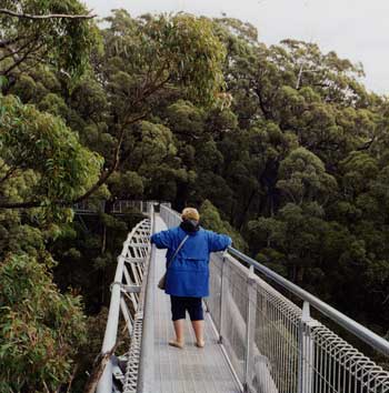
are huge, and a walkway has been built up into them where they grow in a
gorge. The walkway is narrow enough that you can easily hold onto both
railings, and is reinforced entirely from below, so there are no cables
or such to obstruct the view. which is pretty awesome! The highpoint is
about 40 meters off the ground - about 130 feet, and there you are among
the leaves and branches, just like a bird or squirrel. There are plenty
of treetops above, and a lot of space below. Using a camera feels as if
it's TRYING to jump out of your hands into the void. Tony Shepherd, the
architect, made sure that we knew that "if it didn't sway a bit it would
be too brittle, and break...", but Mary still didn't like the movement.
Mind you, her knees hurt a lot, so she doesn't feel too sure on her
feet. At least the walkway eases up and down, so even a person with
walking problems can do it.
The whole area contains patches of Jarra Trees, not as big as the
others, but a very valuable timber tree. The wood is a very beautiful
purplish red, hard and durable. It is so rot resistant that even though
it is a fine furniture type wood, in the old days it was mostly used for
railroad ties. It was also exported - some streets in London, and Berlin
are paved with Jarra blocks!
The really big trees are the Karri, which are only just a tad smaller
than our California Coast Redwoods. They often have the smooth, grey
eucalyptus bark rising like marble columns into the sky. Very
impressive. Not as good when the peeling bark is still hanging on, but
many are so smooth. The Karri is also a valuable timber tree, a less
dark red than Jarra, and not cut much now, as the old groves are so
beautiful. In the old days, Karri timber was used for piers and wharves,
as it is very durable in salt water.
The trees are so tall that the only way to build fire lookouts years
ago was to make a platform in a tall Karri on a hilltop. There are
several of these one can visit near Pemberton. We went to "The
Glouchester Tree"; there is a climbing arrangement of iron rods, kinda'
like 'rebar' pounded into the trunk about a foot apart in an easy spiral
around the tree - 'way 'way up. Not for us. We took photos of each other
On one dirt road among the Karri's
From Pemberton, it was straight west thru Virginia-like landscapes
(with different plants, of course: just trying to give you a feel for
the area), then a bit south to the town of Augusta (not Port Augusta),
and then a few miles to Cape Leeuwin, where the Southern (Antarctic)
ocean meets the Indian ocean. I dipped a finger in for a taste of the
Indian Ocean, and have now tasted all the oceans. They are all salty. I
climbed the lighthouse
We spent the night not far from Augusta and had breakfast in a nice
little cafe where we had lunch the previous day. Then north to Margaret
River - a somewhat "touristy" town which for some reason Australians
consider to be the goal of a trip to the Far West. We opt for Augusta.
It's wine country, but so is Augusta, and for that matter, anyplace in
Australia where there is enough water.
We went up almost to Bunbury, a small city north of there, and the
roads actually began to be full of traffic and all that 'city' stuff -
McDonald's and all, so we were off into the countryside. Drove on and on
thru an idyllic countryside just about as far from the hustle and
problems of the modern world as one can get. It felt "50's -ish". So,
when we stopped for gas at an open-fronted supermarket in Collie (HAD to
go thru 'Collie', since our dogs are Border Collies) the young lady who
pumped the gas, upon hearing my American accent said: "What MADE you
come HERE?" It's all in your perspective - teenagers don't want
'peaceful'!
If you aren't looking at a map, consider that this corner of Australia
is shaped a lot like the west coast of the USA - Augusta would be where
San Diego is, Bunbury about at La Jolla, and Collie around El Cajon. Our
next destination was Hyden, to see
Imagine the shock on the truck which did come by at about 6:45 the
next morning. Here he is, driving thru almost empty country, wheatfields
for mile after mile, no cars, no houses, and here beside the road stands
this bearded guy with a camera, photographing the brilliant sunrise!
Where'd HE come from? Came from the camper just thru those mallees. Woke
up, noticed it was getting light, screamed: "Mary, it's a world-class
sunrise!" and went running thru the trees getting dressed and stuffing
cameras in pockets. Got that sucker, too! A real good one. Poor Mary
missed it - I had thought she was almost awake because she was rolling
over as I shouted. She wouldn't have had time to get thru the trees for
a really good view - these things don't last long, and she does move
more carefully than I do.
One of the neat things about this area is it's remoteness, but that
carries a penalty - there are no roads going back east: it's north, or
south, take your pick. Even though we'd been to Esperance, to the south,
we decided to go there rather than thru Kalgoorlie, north of us. Glad we
did. It had been grey and rainy when we first were in Espreance, and
this time the
Have I mentioned that the sun - although it goes east to west of
course, APPEARS to go the other way, because in the southern hemisphrer,
east to west is COUNTER -clockwise? Takes some 'getting used to' Mary
decided not to worry about it, and declared that "the sun rises in the
south and sets in the north - so there!"
A couple of days on the Eyre HIghway brings us back to Port Augusta,
good grocery stores, cheaper gas, and fish and chips at Barnacle Bill's.
The girl behind the counter remembered us, so we got to talking. I asked
why they didn't list crab among the range of seafoods (Port Augusta is
on a gulf and is a big fishing area) - since I had seen photos of huge
crabs that looked like Chesapeake Blue Crabs on stearoids. Apparently
they DO catch them - 'there's a place about 20K down the coast west of
here where I hear the water is full of 'em". Apparently they are just
caught by those sport fishermen who happen to want to. Unusually for a
young person, she really liked the idea of the way we travel, stopping
whenever it gets dark - and even offered the opinion that since "All
cities are basically the same - just city" that travelling the
countryside is cool. I'm in full agreement.
I did say that Venice is worth the trip, and she agreed, having been
there twice. I'm pretty sure she was a refugee from Yugoslavia, there
are a lot of them in the area.
SO, we 'hung a left' at Port Augusta and headed north on the Stuart
Highway (remember - not Sturt, different explorer) for Ayer's Rock, now
called 'Uluru'.
When I was here in '97, we didn't have time to go west, so we made an
"executive decision" that a treeless area along this highway was "part
of the Nullarbor Plain" - and I'd say we were right. The road goes
northwest thru the "Gawler Ranges", a couple of small mountain
ranges somewhat similar to Nevada, complete with some salt lakes (east
of here, on hundreds of miles of dirt roads, is Lake Eyre, a huge and
very shallow depression which becomes a lake when it rains up in
Queensland, about a thousand miles away).
To increase the resemblance to Nevada, the road goes thru a restricted
military test site - Woomera - jointly under the Australian and US
military. You have to understand that there is a LOT of country out
there. Remember that Japanese fringe group that gassed the Tokyo Subway
with Saran Gas some years ago? Well, they own (owned??) a big slice of
land north- west of Ayer's rock, and it's thought that they tested their
own Atomic Bomb out there - but no one's sure. THAT kind of 'lots of
land' - I always say that if someone misplaced Texas out there and it
was more than a mile off the road, no one would ever find it.
Anyway, drove for two days north, and turned west at Erldunda, to
drive about 5 hours to Ayer's Rock. Costs $15 a person to get in
(shucks, that's only $7.50 US) and it's worth it. Driving toward here,
you pass Mt. Connor, south of the road - looks like an Arizona Mesa that
'got misplaced', but
The place is administered by/for the local aboriginal tribes, and so
there are some contradictions. They 'ask' that tourists not climb the
rock - and provide safety chains. There are sacred sites at various
places 'Please no stopping or photographs" the signs say, and there are
parking areas and paved trails - even wooden boardwalks over a sacred
pool. So if you don't take pictures like everyone else, you will be the
only one.
About 15 miles away, to the west, there is another rock formation -
We camped at a roadside rest area east of Ayer's Rock, same place I
camped back in '97. There were a lot more other vehicles this time,
including a retired couple who now live in their camper, and some young
guys in an old Suzuki 'Samurai' (Called a 'Sierra" in Australia) which
had bolts falling off the engine and wouldn't start until I came over
with jumper cables.
It was so clear that night, and we were JUST far enough north, that we
saw the Big Dipper - upside down - lying flat on the horizon. Cool,
seeing a north circumpolar constellation and the Southern Cross at the
same time.
Go to
Part 5: The Red Centre to Pinaroo
 Mary particularly didn't like the fact that
the platform areas, supported on top of foot-diameter steel pipe posts,
swayed also! After being in the treetops, there are also walkways along
the ground - harder to negotiate, what with steep stairways and such.
Mary particularly didn't like the fact that
the platform areas, supported on top of foot-diameter steel pipe posts,
swayed also! After being in the treetops, there are also walkways along
the ground - harder to negotiate, what with steep stairways and such. on the tree, but not further up than we would want to fall! The guys who
built it had to sit on one rung of this open air ladder while boring
holes and pounding in the next rung. The story is that a guy was up on
ome of these lookouts when a storm came up, withlightning all around. He
phoned the boss with his fears and was told that there are plenty of
tall trees that have survived. He said "there are also hundereds lying
on the ground - I'm leaving!"
on the tree, but not further up than we would want to fall! The guys who
built it had to sit on one rung of this open air ladder while boring
holes and pounding in the next rung. The story is that a guy was up on
ome of these lookouts when a storm came up, withlightning all around. He
phoned the boss with his fears and was told that there are plenty of
tall trees that have survived. He said "there are also hundereds lying
on the ground - I'm leaving!" , we came around a bend to see a
large kangaroo lounginf in the middle of the road. He looked at us with
disgust for interrupting his nap and slowly got up. There was a lot of
peeled bark on the road which crunched under our wheels, so we got the
impression that we may have been the only car in days - this isn't a
heavily travelled area.
, we came around a bend to see a
large kangaroo lounginf in the middle of the road. He looked at us with
disgust for interrupting his nap and slowly got up. There was a lot of
peeled bark on the road which crunched under our wheels, so we got the
impression that we may have been the only car in days - this isn't a
heavily travelled area. , and Mary gaurded the door. It's only climbable
with a docent, who locks the stairs when a group is in ther, and sure
enough, several people came and expected Mary to let them in. As if she
could, without a key. I had hoped to paddle my inflatable kayak out to
this world-class cape, but there were some 'sleeper' waves that might
have dumped me in the cold water, so I wimped out. Turns out that was a
good idea, because the boat is quite suceptible to winds, and wouldn't
have been fun there with about 270 degrees of ocean around!
, and Mary gaurded the door. It's only climbable
with a docent, who locks the stairs when a group is in ther, and sure
enough, several people came and expected Mary to let them in. As if she
could, without a key. I had hoped to paddle my inflatable kayak out to
this world-class cape, but there were some 'sleeper' waves that might
have dumped me in the cold water, so I wimped out. Turns out that was a
good idea, because the boat is quite suceptible to winds, and wouldn't
have been fun there with about 270 degrees of ocean around!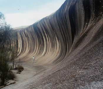 Wave Rock, a granite outcrop with
it's one side weathered to the shape of a huge, cresting wave. It
actually is impressive. Hyden is about where Las Vegas would be on the
US map. There are some small towns, but so little population that to
conserve money and rescources, the roads are just paved - one lane -
down the middle. You play 'chicken', pulling off on the extra-wide
shoulder when a car comes at you. We got to Wave Rock in the afternoon,
and camped off the road around 25 miles east of there - a really nice
"home", as we call it ("if we lived here, we'd be home now") - a little
loop left over where the road was straightened when they got around to
paving it. Nicely screened from "traffic".
Wave Rock, a granite outcrop with
it's one side weathered to the shape of a huge, cresting wave. It
actually is impressive. Hyden is about where Las Vegas would be on the
US map. There are some small towns, but so little population that to
conserve money and rescources, the roads are just paved - one lane -
down the middle. You play 'chicken', pulling off on the extra-wide
shoulder when a car comes at you. We got to Wave Rock in the afternoon,
and camped off the road around 25 miles east of there - a really nice
"home", as we call it ("if we lived here, we'd be home now") - a little
loop left over where the road was straightened when they got around to
paving it. Nicely screened from "traffic". weather was glorious, and the
  'Bay of Isles' at Esperance
was beautiful. On a map it just looks like there are some islands
offshore, but from the waterfront it looks like another coast, blue
above blue water. Then back to Norseman, and off on the Eyre Highway
again. Originally, I had considered taking the train to Pert, and
getting the car there to avoid doing this road twice. SO glad we didn't.
This way we got more time with Disa, and we got to see that lovely
country twice. It even worked out that when we originally came west
there were a lot of clouds, so we weren't driving into the sun in the
warm afternoons, and going back east the skies were blue, for a
different perspective.
'Bay of Isles' at Esperance
was beautiful. On a map it just looks like there are some islands
offshore, but from the waterfront it looks like another coast, blue
above blue water. Then back to Norseman, and off on the Eyre Highway
again. Originally, I had considered taking the train to Pert, and
getting the car there to avoid doing this road twice. SO glad we didn't.
This way we got more time with Disa, and we got to see that lovely
country twice. It even worked out that when we originally came west
there were a lot of clouds, so we weren't driving into the sun in the
warm afternoons, and going back east the skies were blue, for a
different perspective.  Ayer's rock is this huge red 'rock' - they say it's
unconnected to similar strata below, but is 'the world's largest pebble'
- I don't know. The sides do certainlt look like they just continue
straight down into the ground. Probably the weirdest thing to me is are
the areas where
Ayer's rock is this huge red 'rock' - they say it's
unconnected to similar strata below, but is 'the world's largest pebble'
- I don't know. The sides do certainlt look like they just continue
straight down into the ground. Probably the weirdest thing to me is are
the areas where  wind erosion has dug pockets in the sides. I've seen a
lot of wind erosion, and it's usually rounded caves, but these are
irregular clusters of pits which don't seem to follow the strata, and it
looks like the surface - whatever the local strata - is a hard shell,
with these 'shapes' inside. It looks kinda' 'organic', like it is a huge
animal with some skin off - or a huge flying saucer which has been
rusting since it crashed a couple of million years ago, and the internal
machinery is showing here and there.
wind erosion has dug pockets in the sides. I've seen a
lot of wind erosion, and it's usually rounded caves, but these are
irregular clusters of pits which don't seem to follow the strata, and it
looks like the surface - whatever the local strata - is a hard shell,
with these 'shapes' inside. It looks kinda' 'organic', like it is a huge
animal with some skin off - or a huge flying saucer which has been
rusting since it crashed a couple of million years ago, and the internal
machinery is showing here and there.  'The Olga's', named after a Queen Olga of Spain. (No kidding, and I
can't explain it, either. OR why a queen of Spain would be 'Olga')
These are an entirely different kind of rock - pebbles and boulders
naturally cemented together (Ayer's Rock is sandstone), and eroded sort
of like granite erodes, say, at Joshua Tree NP in California - big
rounded things with sharp crevices in between - sort of like a close
-bunched herd of elephants from the rear. Unfortunatly, the best view is
from a platform built on a big red sand dune, too difficult for Mary to
get to. Similarly, the road between Ayer's rock and there, going back to
Ayer's, keeps approaching some really good views - and sweeping down
into valleys just before the view is complete. I know that the 'hills'
are sand, but one does keep wishing that the route could somehow favor
the sight of the thing you came to see.
'The Olga's', named after a Queen Olga of Spain. (No kidding, and I
can't explain it, either. OR why a queen of Spain would be 'Olga')
These are an entirely different kind of rock - pebbles and boulders
naturally cemented together (Ayer's Rock is sandstone), and eroded sort
of like granite erodes, say, at Joshua Tree NP in California - big
rounded things with sharp crevices in between - sort of like a close
-bunched herd of elephants from the rear. Unfortunatly, the best view is
from a platform built on a big red sand dune, too difficult for Mary to
get to. Similarly, the road between Ayer's rock and there, going back to
Ayer's, keeps approaching some really good views - and sweeping down
into valleys just before the view is complete. I know that the 'hills'
are sand, but one does keep wishing that the route could somehow favor
the sight of the thing you came to see.