to next page
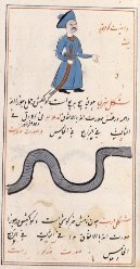
Mustawfi, Hamd-Allah ibn Abi Bakr Qazvini (1340) Nuzhat al-qulub (The Pleasure of Hearts) from Qazvin Persia
----------------------------------------------------
CHAPTER XVIII
The Nile. Its waters are wholesome and sweet, to the extent that to strangers it seems as though they had been artificially sweetened. Ibn Khurdadbih states that the Nile rises in the Mountains of the Moon, on the further side of the equator. It flows from south to north, and when it reaches this side of the equator, its streams come together to form two Lakes. Leaving these Lakes it passes beside the deserts of the Zanj, and of Abyssinia, and of Nubia, till it reaches the kingdom of Egypt, and here it is greater in size than the Shatt-al-Arab (Euphrates and Tigris Estuary).
CHAPTER XX
The Seven Seas, and the Circumambient Ocean......Third, the Sea of Zang (Zanzi-bar). The island of Waghlah, and others. Fourth, the Western Sea.....
The Sea of Himyar. This is an arm of the Indian Sea, and it is also known as the Sea of Barbar. Its eastern side is closed by the Indian Sea, to the west lie the lands of Himyar, on the north are the provinces of Barbar and to the south the Mountains of the Moon. This sea is smaller than the two other arms already described of the Indian Sea. Its length going northwards is 160 leagues, and its breadth from east to west is 33 leagues. It contains many islands.
The Third Sea. This is the Sea of Zang, and in form it is like the Indian Sea, but without arms; and it is very stormy, its waves being more huge even than those of the Indian Sea, and these waves are known as the mad waves. Its waters are very dark in color. Qazvini states that from many of the islands here the north pole cannot be seen, which is to be accounted for by their lying south of the equator. In books on cosmogony again, it is stated that, in one of the many islands here, both the poles are visible at once, and hence this island must lie exactly upon the equator. Now in this sea there are 1300 and odd islands. The best known of these is the Island of Waghlah, and Qazvini reports that in this island once every thirty years a star [Arabic] is seen to rise, and if this attains to the zenith, then everything that is in the island burns. The people here therefore, as soon as it becomes apparent that this is going to happen, take their departure from the island, for such time as the calamity may last. Afterwards they return and set to work to remedy the loss sustained.
In the Suwar-al-Aqalim it is stated that in Maghrib, down near the equator where the wind comes from, there is a desert measuring near 500 leagues across every way, most of which is moving-sand. Here the heat and drought prevent any habitations, and by some account this is named Mafazah-al-Alij (the Wilderness of the Sand-hill)
Note: in Adolf E Jensen; Myth, Mensch Und Umwelt I found a different translation for this: a desert in Sofala of the Zandj ......
In the Jami-al-Hikayat it is related that on one side of this desert there is moving-sand, across which is but a single road, and this road is only open one day in each week, namely on the Saturday. In the middle of these sands stands a city where all the inhabitants are women, and if a man should manage to get there, by the effect of the climate his manhood goes from him, and in a short time he dies. Among these women the act of generation is effected by means of a certain spring, in which when the woman has sat she becomes pregnant and bears a daughter. For if at any time a boy is born, he dies in childhood.
CHAPTER XXV
Hind. This comprises many kingdoms by land and (numerous islands of the) sea. They have mostly a hot climate, and by reason of the broad area occupied by all these, it is said that India covers one sixth of the habitable earth. In this work we can only name a few of the most celebrated places here, and as it is well known, the number of people and troops in those kingdoms is quite beyond count. Its greatest city is Delhi in the Second Clime, this being now the capital of the Sultan. A city of almost equal size is Duwirqir (Dawlatabad) of the Second Clime. Then there is Zaytun and Ceylon of the First Clime; also Sumnath and Qanawj of the Second Clime; Cambay and Gujarat, Murgh and Mah likewise of the Second Clime. Next come Coromandel (Ma'bar), Maqdashu, Malabar, Talang and Qal'ah, this city lying on the frontier of China, where there are the famous tin smithereens, for which reason tin is often called Qala'i. Lastly come Arur and Tanah, with other celebrated towns and districts, beyond count or compare. Now many, as for instance Malabar, Gujarat and Cambay have each of them 70,000 villages, together with very many dependencies belonging to them.
Note: We have here a very important paragraph; Mogadishu is considered part of India. He is not the only Muslim author to do so.
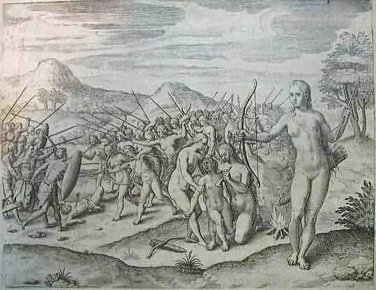
The best of the legions in the emperor of Monomotapa were women who were trained to fight from infancy and had their left breast burnt off, so as not to hinder them when shooting with their bows and arrows, with which they were very accurate, just like the Amazons of Amazonia. These women were strong and sturdy and lived in their own territory, which was given to them by their emperor. At certain times they went off to visit the men, picking out whosoever they chose. When a warrior woman gave birth to a son, the son was sent to live with the men-folk, but if she had a daughter, the daughter was kept with the women and trained as a fighter.