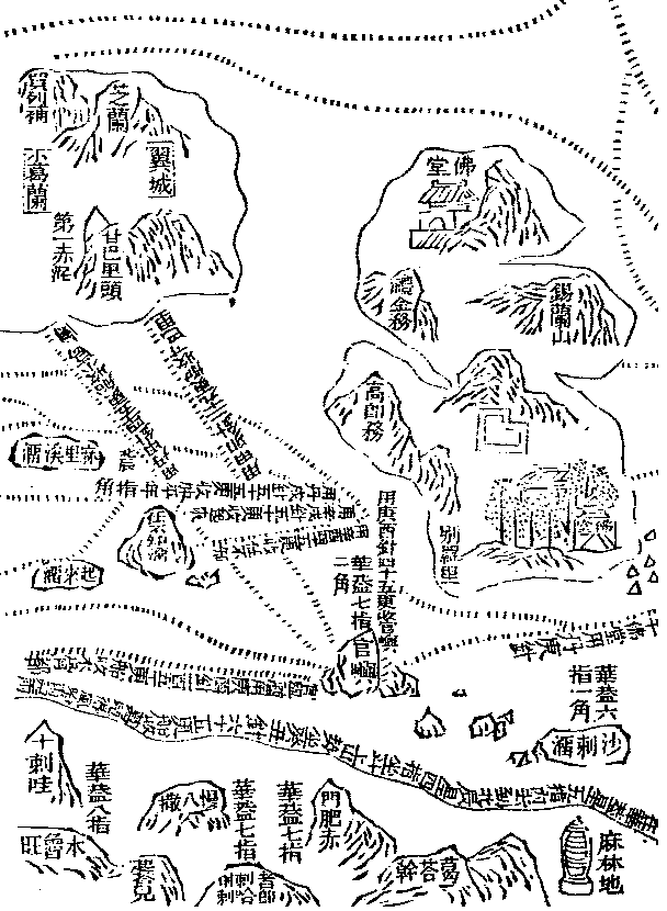
Maokun's map of east Africa translation

(Brava) Hua Kai
8 fingers Man-pa-sa Men-fei-ch'ih Ma-lin-ti
(1 deg 36' N) (Mombasa) (Mafia island) (Mozambique)
Mu-lu-wang Hua Kai 7 fingers Hua Kai 7 fingers
(Brava)
Ch'i-ta-erh Che-chi-la Ko-ta-kan
(Ras Kitao?) Ha-tse-la (Quitangonha island)
(Gezira,Gezira?)
------------------------------------------------------------------------------------------------------------------------
Note: Hua Kai is a star used for navigation; example; In Mombasa is Hua Kai at its highest point 7 fingers above the horizont. It is not known which star is used. The Pei ch'en star which is also used is the North star.
Sailing Directions
On the map are also two important sailing directions:
The first one starts from Male (Maldives) to Mogadishu; it reads:
From Kuan hsu liu (Male Island) steer 255 deg-270 deg ; after 150 watches the ship makes Mu-ku-tu (Mogadishu).
The second one is the one which winds along the east coast of Africa. It reads;
(we start reading from the south) (When you are ) in ( the latitude where the altitude of the ) Hua kai star (is) less than 5 fingers ( 3deg 12' S) (and) are going to (the latitude where the altitude of the ) Pei ch'en star (is) 4 fingers (6deg 25' N), you set (your course) upon the Tou (star) (Alpha, Beta, Gamma, Delta of Ursa Major). When mountains appear, you set a compass (-course) of 15 deg-30 deg. (After) 65 watches the ship reaches Ko-erh-te-feng (Guardafui), (which is) Ha-fu-erh-yu (Hafun) . (When you are ) in (the latitude where) the angle is 3 fingers (4 deg 49' N), mountains appear. Going to (the latitude where the altitude of Pei ch'en is) 6 fingers 2 quarters (10 deg 26' N) (you go) straight around that place on (a course of ) 60 deg...... Again (when you are ) in (the latitude where the altitude is ) 6 fingers 2 quarters, there will be mountains to landward.
Translation taken out : Ma Huan : The overall survey of the ocean's shores (1433)
translated by Feng Ch'eng-Chun 1970
Note that the big island is Ceylon; the small islands in the middle the Maldives and the land in the upper left corner South India.