To next page
The Mao K'un Map (introduction)
------------------------
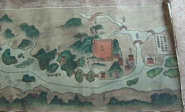
This is the beginning of the Mao Kun map. The drawings you will see further on are redrawn parts of it (by hand). On the internet many by hand redrawn parts are found. Sometimes with modern inscriptions. (Simplified Chinese.)
Neville Chitick: East Africa and the Orient
Ma Huan: Ying yai sheng lan chiao chu ; translated by Feng ch'eng-Chun
Kuei-Sheng Chang : in Terrae Incognitae III 1071
Duyvendak : China's Discovery of Africa (1947)
www.hist.umm.edu
This is a reproduction of Zeng He's 1422 - 21 feet long sailing map.
Published in Wu Pei Chih (1620) (Notes of military preparations) by Mao Yuan-Yi.
The map however is made by Mao Kun (1511-1601) This are dates quite outside our historical period, but the original records of Zheng He's voyages have been destroyed.
It consists of different maps of which one shows Zheng He's voyages to Africa. The maps are added hereafter; The first shows the part of, on top the straight of Hormuz down from it is the Arabian Peninsula and on the other side of the sea the coast of India. The second map starts with in the left upper corner the entrance to the Red Sea, the island of Socotra, and the east-coast of Africa. In the middle are the Maldives. And on the other side the coast of India continues, followed by the island of Ceylon. The end of the map shows the road to Asia.
The Mao K'un's map gives specific sailing directions from Male' (capital of the Maldives) to Mogadishu, Cape Comorin and Quilon, (both in Southern India) specifying both astronomical data and exactly how many days it took to reach these destinations. It took 150 watches direct from Ceylon to Maqdishu. To navigate from Male to India the instruction reads; Steer exactly 75 deg. After 75 watches the ship makes Quillon.
Malindi is clearly misplaced and put away to far south. This puts doubts to the fact if Zheng He ever visited Malindi.
The furthest point reached is called Habuer. There it is said heavy storms stopped the fleet going further. It does not show up on the map only in the annotations.
Important place names are accompanied by a statement of their latitude in terms of the altitude of the pole star measured in "chih" fingers and "chiao" quarters (a direct translation of the Arabic isba - fingers and Zam) above the horizon. This practice is absent from the other parts of the map. This proves that the Chinese used Arabic material to assemble the map of east Africa.
Che chi la ha tse la OR Che tse la ha tse la : Written between Mombasa and Mafia island off the east coast of Africa; perhaps Jezira, Gezira, island, referring to the islands of Pemba and Zanzibar.
And Ch'i ta erh : A place between Brava and Mombasa on the east coast of Africa; perhaps Ras Kitao on Manda island.
About La-ssu Na-ha: Many recent articles of the internet have made Pate island the La-sa visited by Cheng-He; However the description given of La-sa is one of a desert. Also there is on the Mao K'un map a La-sa located in Arabia. Also the location; before reaching Mogadishu is wrong. An other explanation is given as Alnaha of Idrisi's map of 1154 or the Alnga of his 1192 map
Four of the star maps of Cheng Ho have survived, unfortunately none about Africa. They were made by Mao Kun (just as the map) and the position of the stars in it makes it possible to decide on when they were made: 1420 with an error of 20 years. They were however published together with the Mao Kun map. We also know that starting from the southern tip of Sri Lanka to the East Coast of Africa these star maps were the only way to navigate, the compass being to little accurate.