Da Ming Hun Yi Tu (1389)
(Amalgamated map of the great Ming empire)
----------------------------------------------------
Taken from: news.bbc.co.uk and ruf.rice.edu and uni.erfurt.de and taint.org and exboard.com

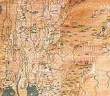
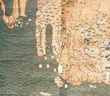
Drawn on a horizontal scale of 1:820,000 and a vertical scale of 1:1,060,000, it covers an area extending all the way from Japan to the Atlantic Ocean (including both Europe and Africa), and from Mongolia to Java. Although the section on China seems to be derived primarily from Zhu Siben's Yutu, the renderings of Africa, Europe and Southeast Asia appear to have been based at least in part on Li Zemin's Shengjiao guangbei tu (Map of the Vast Reach of [China's Moral] Teaching; c. 1330), no longer extant."
The map also shows a great lake, covering almost half the continents land mass. Researchers suggest it may have been drawn on the basis of an Arab legend that stated "further south from the Sahara Desert is a great lake, far greater than the Caspian Sea".
Place names are written mostly in Manchu, a now virtually extinct language, and still in need to be translated.