Back to Table of Contents 4     To next page
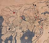
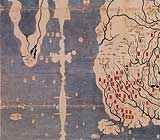
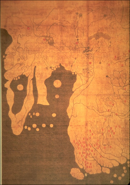
Ch'uan Chin and Li Hui (1402)
(Yoktae chewang honil kangnido) (Map of Historical Emperors and Kings and of Integrated Borders and Terrain)
---------------------------------------------------

Taken from Philip Snow : The Star Raft
                 Imago Mundi 10,1950
Map taken from : www.henry-davis.com/MAPS
This is a map based on the work of two Chinese cartographers which appeared in Korea in 1402 it adds a stream emerging on the African continent's south west coast in the approximate position of the orange river. This map and the one of Chu Ssu Pen place the southern part of Africa immediately opposite the Indonesian islands, with a string of smaller islands in between, and the tip of India tucked far away to the north. This could suggest that whoever supplied the data on Southern Africa did not get there from the Persian Gulf, by the established Muslim sailing route. But crossed from Sumatra and followed the chain of southerly islands, Maldives, Chagos and Mascarene, which stretch across the western Indian ocean at conveniently short intervals all the way to Madagascar.  

There is really a good chance that this information came from Malay sailors going to their settlements in Madagascar and Africa. And that the maps were made in preparation of the trips of Zheng He.     

They use the Ptolemyan  map of Africa, drawing a big lake as the source of the Nile, and indicates there: Zhebulu Hama, (from Persianized Arabic Djebel alqamar) the mountains of the moon.
The island in the big lake of Africa has the name: Huang sha: desert
The large round island east of Arabia Hai-tao: Ceylon
India is only visible with the Ganges.
In the utmost NW Germany is given as A-lu-mang-ni-a and France as fa-li-si-na
There are in fact two Kangnidos; one of 1402 and one of 1420. The inscriptions are partly different. Only details of both maps are given here
Hosted by www.Geocities.ws

1