To next page
Prince Abu al-Fida (or Abulfida) (1273-1331) Taqwim al-Buldan (Geography of countries) (he was governor of Hanah in Syria)
---------------------------------------
Left; The worldmap of Abulfeda
- Marcel Devic ; le pays des Zendjs
-N. Levtzion and J.F.P.Hopkins; Corpus of early Arabic Sources for West African History.
-Reinaud : Geographie d' Aboulfeda
The equator, starts from the sea of China, goes through the sea of India to the land of Zendj and of the western Negroes and arrives at the encircling sea on its western side.
The big sea, in the south of the inhabited world, is in contact with the eastern sea, and has several names, according to the lands on its shore or the islands in it. The southern sea starts in China and passes by India towards the land of the Zendjs.....
The furthest part that people visit who navigate this big sea, on the western side is Sofala of the Zendjs. The sailors never pass that point. The reason being that in the south east the sea throws itself on the coast, and cuts into it at several places and the islands are numerous. As opposite, on the south western side as compensation it is the continent that stretches into the ocean. This place is inhabited by the western Negroes. It stretches from behind the equator till the mountains of Qomr, where the Nile has its sources. From there on the sea has to run between mountains and valleys that go up and down; the water is constantly on the move because of the endless flux and reflux of the sea. When the waves meet each other the boats are put to pieces. That is why they hardly navigate it. That does not stop the southern sea to communicate with the ocean, through these narrow spaces and through the space there is behind the mountains on the southern side. This connection with the ocean has been proven, although nobody has been able to see it with his own eyes. (this whole long paragraph Aboulfeda copied from Biruni in his Qanoun.)
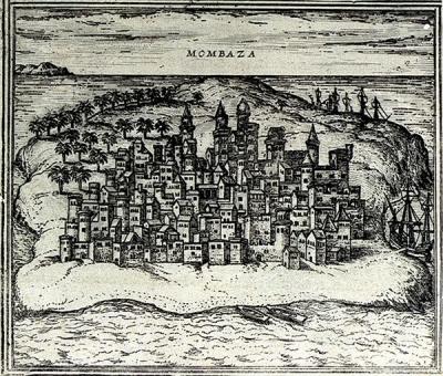
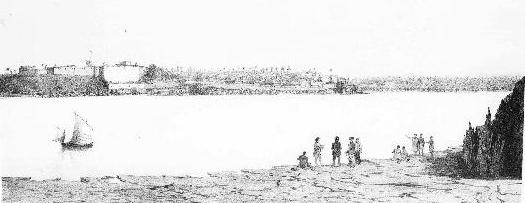
Here we a have a map of Mombasa from 1550
The channel Berbery (Alkhalydj Alberbery) is an arm of the sea that detaches from the Indian Sea, to the south of the Mountain Mandeb and the land of Habesch, and which stretches to the west, up to the town of Berbera, in the land of the Zendj, under 68 deg longitude and 6 deg and a half, or, according to the author of the Canoun at 12 deg latitude. The length of this sea, from east to west is about 500 miles. Extraordinary things are said on the subject of the waves of this sea. Scherif Edrisi says that the waves go up like high mountains without breaking. He adds that it is through this sea that one goes to the island of Qanbalu, the island occupied by the Zendjs, and where there are Muslims.
Lake Koura
Ibn Said says that it is a lake on the Equator from which, on the north, issues the Nile of Egypt, on the east the Nil of Maqdishu, and on the west the Nil of Ghana. The range of mountains called Jabal al-Muqassim (or Almacsam) (the divider) curves round its south-eastern side from under which the Nile of Maqdishu issues. The rivers coming from the two lakes above mentioned flow into it. As for al-Sharif al-Idrisi, his account is the same as that of Ibn Said as far as the issuing of the Ghana Nil from lake Kura is concerned, but then he says that Ptolemy denies this and asserts that only the Nile of Egypt issues from it, and that the source of the Ghana Nil is beneath a mountain range there. The author of the Rasm al-ma'mur ( or Resm-Almamour) says that this lake (Lake Kura) is a circular batiha standing on the Equator with a diameter of two juz and its center in longitude 53.5 deg and latitude 0 deg (or according to another version 2 deg N), which would make the longitude of its western side 52.5 deg and its eastern side 54.5 deg.
The Mountain of Comr
(or Jabal al-Qamar). There is a difference of opinion concerning the vocalization of the above mentioned Jabal al-Qamar (or djebel Alcomr). Some assign it to the qamar 'moon' which is in the sky and write the qaf and min with fatha but I have seen it vocalized in the book of Yaqut which he named Al-Mushtarik wad'an al-mukhtalif suq'an 'Places which share in the spelling but differ in locality' with damma of the qaf and sukun of the mim. He also mentions the island of the Zanj which is in the remotest south and states that its name is Jazirat al Qumr, with damma of the qaf and sukun of the min; I have also seen it in the book of Ibn Said al Maghribi with damna of the qaf and sukun of the mim. It is also mentioned by Ibn al-Mutarrif in the Tartib. He does not mark the vowels but says: It is derived from snow blindness (qamar) of the sight. It is a range in the southern wilderness (kharab). Its latitude is 11 south of the Equator. From it are the sources of the Nile of Egypt from ten torrents which descent from it. It is not certain whether anyone has reached it but it has been seen from afar. Al-Nasir al Tusi says in the Tadhkira that they saw it from afar. It is white from the snow which is upon it. In my opinion this is far fetched for the latitude of 11 deg south is in extreme heat. It is the equivalent of 11 deg north, which is the latitude of Aden in the Yemen, and the falling of snow in a latitude like that of Aden has never been heard of at any time. The southern side is like the northern, but even hotter, because of the sun's being overhead. It says in the Kitab rasm al-ard (or Rems-Alardh): The western end of the Jabal al Qamar aforementioned is in longitude 46.5 deg and in latitude 11.5 deg south of the equator. On this basis its length from its western end to its eastern end is about 15 deg approximately. The Rasm al-ard continues: Its color is red and its highest point is towards the south (wa-ra'suhu ila jihat al-janub) This report differs from that of al-Nasir ( or Nassyr-eddin) that it is white.
..........One of the islands of the sea of Zanguebar is the island of Komar. You read it in the Mostarik: Komr is an island in the sea, in the middle of the land of Zanguebar, it is the biggest island of that sea.
Table of the islands in the Eastern Sea.
The island of Qonbolah
According to the Qanoun; 52 deg longitude and 3 deg latitude. To the south of the first climate. In the channel of Berberi. (al-Khalij al Barbari.)
One reads in the Atwal of Faras: Qonbolah is the capital of the king of the Zindj. Ibn Sa'id says that between this island and Faqati (or Baqati) there is 2.5 deg and that the south coast of the island of Qonbolah on the same line is as Faqati; Qonbolah, he adds, is about two deg. long and as width. Formerly prosperous, it is now in ruins.
The island of Qomr:
The Negroes of the land of Qomr as well as most of the other people in these regions says Ibn Said eat human flesh.
Ibn Said gives the island of Qomr a length of four months walk and a maximum wide of 20 days. Beginning in the east of Seyouna, it forms with the continent a canal that finishes at the Djebel en-Nedama and is at that place 200 miles large. There are there they say places that swallow ships.
The island of El-Qomr is often confused with Qomar, but is different from it because it is situated in the sea in the middle of the lands of the Zendjs, and that sea does not have a bigger one (island).
He gives the western site of the Kamar mountains with 46.5 deg longitude and 11.5 deg latitude south and it stretches till 6.5 deg towards the east, without changing latitude. Then he still adds from Kitab rasm al-Ard: the color of those mountains is red, and its summit is pointing south.
Those (islands) of that part of the Indian ocean that are in the east and close to China are the Islands of Zabedj as Al Biruni says, the islands situated in the west are the islands of the Zendjs.
Siraf
........ houses are built in this country in teak wood and an other kind of wood which is imported from the land of the Zindj......
Sofalah of India
........this Sofala is the one from India; there is another one in the land of the Zindj........
Sohar:
Out of a book called Azizi from the tenth century Abulfeda extracted the following passage concerning Muscat which he calls Oman:
Oman is a pretty little town, with a harbor full of ships from Sind, India, China, and the lands of Zaguebar. Before, the capital was Solhar, you do not find a more pretty town on the Persian Gulf.
The purport of Ibn Said's remarks is that if we begin at the western end of the land of the Sudan the first thing we find is some of the towns belonging to the Sudan who are naked and unheeded, like animals. He mentions some of their towns, the names of which are non-Arabic and of uncertain pronunciation viz. the town of Manaqlu in longitude 10 deg latitude 4 deg, then Zafu, in longitude 13 deg, latitude 10 deg, zghth, in longitude 24 deg latitude 7 deg; brsnh, in longitude 29 deg, latitude 7 deg, Kusha situated on springs which feed the last river of the second of the Nile lakes, where the longitude is 53 deg and the latitude 2 deg. Beneath it runs the Maqdishu Nil issuing north of the equator. The territory of Qamar lies between the two lakes. The territory of the Akraw and the Qamar mountains, according to what is related after Ptolemy, are in longitude 51 deg 50' , latitude 11 deg. Around these mountains are the settlements of the Qamar after whom they are named and who (says Ibn Said) are related to the Chinese. The notorious fact about them and about most of those who inhabit that land is that they eat any people who fall into their hands.
The river of Macdaschou goes up to 66 deg longitude and 11 deg latitude; then it descends on the eastern side of the town of Berbera. There remains between the river and Berbera about one deg. of distance after that the river enters into the sea, east of Macdaschou. He who goes further to the east, reaches the city of Karfuna in the country of Berbera, still further east the city Berma, still further east Hafuni, well known to travelers, inside the continent it stretches for about 100 miles, also into the sea it stretches for 140 miles, in northern direction but also east, with clearly visible, its 7 tops.
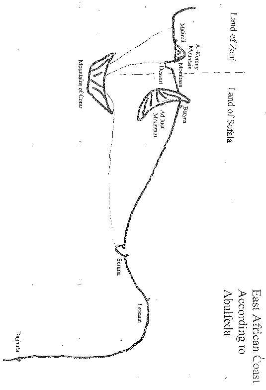
Malindi is a town of the land of the Zanj, 81.5 degrees long, 2 degrees 50 minutes lat.. West of the town is a great gulf into which flows a river. (is the Sabaki) which comes down from the source many hundreds of miles away in the mountains of Comr (Djebel el-Qomr). (meaning the mountains of the moon). On the banks of this gulf are very large dwellings belonging to the Zanj; the houses of the people of Comr are on the south side. East of Malindi is al-Kerany, the name of a mountain very famous among travelers. this mountain runs out into the
sea for a distance of about hundred miles in a north-east direction. At the same time it extends along the continent in a straight line north for a distance of about fifty miles. Among other things which we might say about this mountain are the iron mine which is on the continental side and the magnetic half in the part which is in the sea.
At Malindi is the tree of Zendj (the ginger tree) (or at Malindi there are many Zanjian sorcerers). The king of the Zanj lives in Malindi. Between Mombasa and Malindi is about one degree.
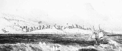
Mombasa is on the coast. On the west is a gulf along which buildings stand, boats go up river as far as 300 miles. Nearby to the east is the desert (mefasa) which separates the land of the Zanj from Sofala.
Among the towns of the country of Sofala is Batyna (or Banyna) (Note this is most probable the Touhna from Idrissi, distorted by a wrong interpretation of the expression : tousamma bi-Touhna; meaning: it is named Touhna). It is situated at the end of a great gulf, away from the equinoctial line, under 2.5 degrees lat., 87 degrees long. According to Ibn Said, on the west of Batyna is Adjued, the name of a mountain which projects into the sea towards the north-east for a distance of 100 miles. The waves of the sea make a great noise here. The people of Sofala live to the east of this mountain: their capital is Seruna (Seyouna), under 99 degrees long. 2.5 lat. (south). The town is build on a large estuary where a river, which rises in the mountain of Comr, flows out. There the king of Sofala resides.
Then one arrives at the town of Leirana. Ibn Fathuma, who visited the town, said that it was a seaport where ships put in and whence they set out. The people are Muslims. Leirana is on long. 102 degrees, lat. 0 degrees 30 minutes (south). It is on a great gulf. The town of Daghuta is the last one of the country of Sofala and the furthest of the inhabited part of the continent towards the south. It is on long. 109 degrees, lat.12 degrees, south of the equator.
Sofala,
According to the canon it is on 50 degrees 3 minutes long. 2 degrees lat, south of the equator. Sofala is in the land of the Zanj. According to the author of the canon, the inhabitants are Muslims. Ibn Said said that their chief means of existence are mining gold and iron, and that they dress in leopard skins. According to Masudi, horses do not reproduce in the land of the Zanj, so that the warriors go on foot or fight from the back of oxen. I have remarked that Sofala is also a place in India.
Matan;
Ibn Said 51 deg., 13 deg. Thus we find in Ibn Said's book.
Ibn Said says; it is level with the angle of the lake called Kuri. South of it is Jimi, the capital of Kanim, and it (Matan itself) is reckoned among the cities of Kanem. This is the lake from which the Nile of Egypt, Maqdishu, and Ghana issue. It is 1,000 miles long. Its eastern end is in longitude 51 deg. its width at the head is 9.5deg, then it gets gradually narrower until its width at the middle is 450 miles and at the tail 360 miles......
Dendema:
According to Ibn Said is the town of Demdems at 54 deg 20' by 9.5 deg. According to Ibn-Sayd, Dendema is the country of the Demdems who invaded Nubie and Abyssinie in 617 AH (1220 AD) at the same time as the Tartars invaded Persia. From there it can be said that the Demdem the Tartars of Sudan are.
Bedje:
According to Athoual at 55 deg longitude and 2 deg latitude. It is outside the first climate, in the south, in the land of Berebra. Do not confuse it with the town in the land of the Bedja, where there is a gold mine of which we already talked.
Carfoune:
According to Ibn-Sayd, 64.5 deg longitude, 0.20 latitude.
It is situated outside the first climate. In the land of the Zendjs. According to Ibn-Sayd, the town is situated in a gulf , in the beginning of the arc of that gulf. That author adds that it is the first town of the land of Berbera, on the shores of the sea of India. To the east is another town of he land of Berbera, called Berma (or Terma) at 70 deg longitude, one deg latitude.
Berebera:
According to the Canon, 55 deg longitude 2 deg latitude. According to Ibn-Sayd, 68 deg longitude, 6.5 deg latitude.
Berbera is the capital of a country that carries the same name, outside the first climate, in the south. According to Ibn-Sayd, Berbera is the principal place of the land of the Barabras (Barabar). Most of the inhabitants have embraced Islam, it is because of that that one does not find anymore slaves of this race in the Muslim countries.
I found another translation of this part of the text:
The land of Berbera belongs to the Zendjs but is ruled by the Habacha, who have put commercial ports there. Since the 13th century the town of Berbera is completely Muslim; that is why Ibn Said says this place offers so few slaves to the Muslim places.
Marka:
According to the Athoual, 73 deg 8' longitude; but after Ibn-Sayd, 69.5 deg longitude, and 1.1 deg latitude.
Marka is outside the first climate, to the south, in the land of Berebra. Ibn-Sayd says it this way: In the east of Khafouni (Ras Hafoun) on the sea shore is the town of Merka, an important harbor. Its people are Muslims. It is the capital of the Haouiya , who own more then fifty villages. It is situated on the side of a river which comes out of the Nile of Maqdechou and which reaches the sea at two days walk from there towards the east. That river makes a bend towards Merka. To the east of Merka is the town of Islam, famous in these areas called Maqdechou.
Macdaschou
According to Ibn-Sayd, 72 deg longitude and 2 deg latitude.
Macdaschou depends of both the land of the Zendjs and Abyssinie, it is outside the first climate on the southern side. Mogadoxo is at the shore of the Indian Ocean, its people are Muslims. There is a big river there that because of its floods in summer resembles the Nile of Egypt. They even say it is a branch of the Nile coming from lake Koura, passes by in the east and goes on to end into the Indian ocean. Ibn al-Madj (or Ibn-Almadjd) from Mosul calls Maqdechou a big (kebira) town of the Zendj and the Habacha.
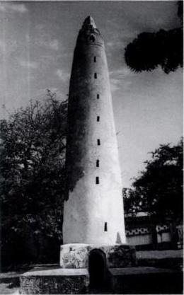
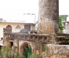
Mbaraki pillar Mombassa; (used in spirit worship)
This might well be the oldest surviving monument in Mombassa. Pot sherds have been found in its neighborhood dating back to 1700 and it is found on a Portuguese map of 1710. This means that it must have been in use as a centre of spirit worship since then and till now. As it is clearly a minaret it must have had an older role which we can not guess when it started.
At the Jumaa or Friday Mosque in Malindi is a pillar tomb build in the fifteenth century that honors
Sheikh .Abdul Hassan, A shorter pillar tomb is thought to have been built in the nineteenth century.
In the courtyard of the Juma'a Mosque (Malindi) you can see the remainings of the old mosque: some scattered old stones and parts of walls, a few simple graves and a pillar grave. This one is really beautiful - and ornated with some fine examples of stone carvings. It's really a lot more interesting than the mosque itself. However it's not quite allowed to walk up to the ruins (the grassy patch is a Muslim cemetery), so you'll have to take your photos from the distance
There is an inscription on the small tomb of Sheikh Hassan bin Bakr inside the
Pillar Tomb at Malindi, which has been read: Ya Allah Ya Mohammed Ya Ali.
This is usually a Shia formulary
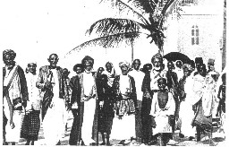
The army of Ali ben Mohammed (Lord of the Zendj) was way bigger. He had found the most important parts among the Zendjs from Iraq-Arabi and mostly from Sibakh.
Note:
Abulfeda writes : At Melinda is found the plant of Zing.
Meaning the ginger tree. The ginger tree however is from India. The official name for the ginger tree is Zinziber what gave many people to think that it grew in Zanzibar. Marino Sanudo's map of the world (1320) gives a rubric connecting Zinziber with Zinj.
----------------------------------------------------------------------------------------------------------------------------
Chronique of Aboulfeda (Historia anteislamica, etc p174)
Among the important black people are the Abyssins, their country is situated opposite Hedjaz; it is the red sea that separates the two countries. This country is long and wide. It is situated to the south east of Nubia. The Abyssinians are those who for a long time occupied Yemen, before Islam. The eunuchs of Abyssinian origin are the most searched of all..................
The Demdems who live on the shores of the Nile, above the Zendjs. These are people indifferent to all religion ; they adore idols and practice different cults. You find there giraffes. It is in the land of the Demdem that the Nile gets divided into several branches of which one goes to Egypt.
The Zendjs; who are the Negroes of the deepest black. They fight mounted on bulls, they worship idols. They are strongly build and used to harsh live. The splitting up of the Nile takes place above their country close to the mountain of djebel Almicsam (the split).
This map of Abulfeda I made by using the coordinates he gives in his text. One can recognize the same East African coast line as Marino Sanudo's map.