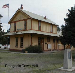
| THE CANELO HILLS* Where are we on the AZT? This segment starts at Parker Canyon Lake and finishes 33 miles later at the town of Patagonia, AZ. Route: The AZT trailhead sign is on the southeast side of Parker Canyon Lake. The AZT traverses the south side of the lake and then heads northwest. The trail is distinct but to find it, particularly as you get further from the lake, you�ll have to look closely for rock cairns as you cross several streambeds. Sometimes the trail doesn�t exit directly across from where it enters a streambed. Stay alert. The trail is hardly ever straight in this segment, winding along streambeds, around the hills, and through Manzanita bushes. A few miles from Parker Canyon Lake, the trail enters the not-quite mountains named Canelo Hills, a good test of up and down (500�-600�) walking for several miles. Eventually the trail leaves the hills, comes to a rancher road, turns left (south I think) and follows the rancher road for a couple of miles. It then turns left thru a gate and follows another road (#4633A) into and across a shady, valley for another mile or two. Enjoy that stretch as the Arizona Trail then begins a long ascent until it reaches a 6,000' ridge. The AZT follows the ridge and soon looks down onto Canelo Pass Road. It's another rocky mile down the ridge and then north alongside Canelo Pass Road (#799) to the Arizona Trailhead. It's a good spot to meet someone after a tough hike from Parker Canyon Lake. The trail crosses FR #799 just north of Canelo Pass, 16 miles west of Parker Canyon Lake. There�s AZT signage in a parking area alongside the road, �14 miles� to Harshaw Road it says. But, there aren�t any streams and the road is a little too close, so unless someone is meeting you there, it�s not a real great camp area. There is a cattle pond about 1/4 mile south of the trailhead. You can't see it from the road but it's just over a small rise about 100 yds west of the road. Continuing on west, after an initial short climb, it�s pleasant hiking as the trail follows a winding trail that offers some great views to the southwest. 3 miles from Canelo Pass Rd., near the area called Meadow Valley, there are AZT signs and a faint trail leading across a field but it soon disappears. Instead, stay on the soft rancher road that branched off to the right about 200 yds east of the signs. The soft rancher road, soon passes thru a gate and continues on an increasingly rocky and up and down road. The road soon drops into the start of Redrock Canyon, passes a cattle pond, and comes to a �don�t camp here� area called Cott Tank. This is a good spot to fill up with water from the faucet near the tank by the solar panel. There's a stream here that may have a little water in it and 1/4 mile west there's someone�s long ago 1 room homestead. Just past the ranch the trail passes thru a gate. The trail goes left here, leaving the road, and enters a side canyon (take the first trail on the left) and reaches Redbank Well in a couple of miles. The deep, rust colored rock cliff at Redback Well can be seen several miles before reaching it. Redbank Well has AZT sign markers, a water tank and it's where the trail turns northwest, passes next to a corral and follows the creek bed. It�s a beautiful area. Springtime yellow poppies are plentiful. But keep your eyes wide open for AZT posts and rock cairns that point the way. About 3 miles from Redbank Well, the trail heads southwest. The last couple of trail miles before reaching Harshaw Road, FR #58, are rocky and the most difficult of this stretch.. Or maybe the anticipation of a cold Pepsi in Patagonia made it seem that way. And yes, the final 3 mile walk on the paved Harshaw Road into Patagonia is very long. My new blisters were crying all the way. Worthwhile Detours from the AZT: The scenery along the trail is wonderful but there ain�t much reason to get off it until reaching Patagonia. Definitely stay a day and night at Patagonia. Stop aand say hi to Ann at Mariposa Bookstore (520-394-9186). She knows all about Patagonia and is also the official visitor center.. If you don't want to stay overnight, there's a RV Park alongside Harshaw Road, on the east side of Patagonia, that may let you take a shower as you pass by. Places to Camp - There�s a nice spot an hour west of Parker Canyon Lake in Parker Canyon where the trail crosses a small springtime stream. Also, there are many nice spots in a 4-5 mile stretch as the trail enters the Red Canyon area west of FR #799. Length - 33 miles Power Rating - This segment was difficult. It was the third and fourth days of my AZT hike. My feet, shoulders and mind were neither prepared nor ready for hiking every day all day. Yeh, I know I�m a wuss. Water* � Parker Canyon Lake has water year round in the lake and at the campgrounds and store. But there's none at the AZTrailhead. The trail crosses a small stream in Parker Canyon about 2 miles west of the PC Lake Trailhead. But there's nothing more until the cattle pond that is 1/4 mile south of the Canelo Pass Road Trailhead. Also, in a pinch, there's some houses a few miles north of the Canelo Pass Trailhead. West of Canelo Pass Road, there's another cattle pond off the trail in the distance at Meadow Valley. About 4.5 miles west of Canelo Pass Rd, you will pass another cattle pond alongside the trail but if you hike further another mile or two to the "Don't Camp Here" area (Cott Tank), there's a solar powered pump that fills a tank which has a faucet. The last likely water spot in this section is Red Bank Well which about 9 miles from Canelo Pass Road. Look for the windmill. It's a pretty reliable source feeding a cattle tank. Also, in the spring of 2001, there were several flowing streams in this west section. That's a possibility in other wet years but not likely every year or at all during other seasons. Bikeable? For the most part yes, though not smooth easy riding and I'd say this is for the more experienced mountain bike rider. You will push your bike up the long steep, rocky mountain that is just east of Canelo Pass Road. And the 2-3 miles northeast of Harshaw Road, east of Patagonia, are filled with loose rock and nearly prohibitively difficult. Permits - None needed. Maps - Coronado National Forest Map, Nogales and Sierra Vista Ranger Districts, 520-670-4552. Also, the ATA sells maps of most AZT segments - call 602-417-9300. Advice � If this section is at the start of your hike, I suggest you make it a three day trek. If you hike it in two days on soft feet, you�ll be dog tired when you reach Patagonia. And, also, stop in the Canelo Hills and take a look back to the Huachuca Mountains. You�ll beam proudly knowing that you hiked thru that big dog Cautions � Bring along some netting to thwart the springtime pesky, in-your-face and mouth bugs. Life on the AZT - As I approached Canelo Pass, FR #799, there were some gallon water bottles placed obviously in the open not far from the road. I assumed it was a local group leaving water for Mexicans coming north. Also, a few miles west of Canelo Pass Road a border patrol plane checked me out as I crossed a large open area. *Remember just about all water sources are seasonal in Arizona. Check with as many sources as possible before entering an area, including the local National Forest Service. |
 |
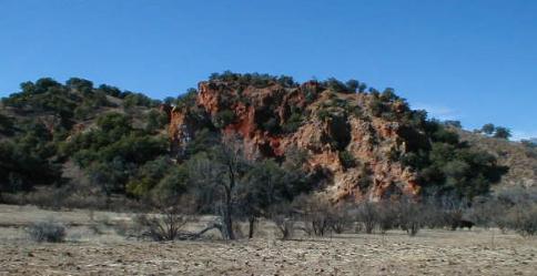 |
| Red Bank in Redrock Canyon |