 |
Deadhorse Diary 2005 |
|
| Sunday,
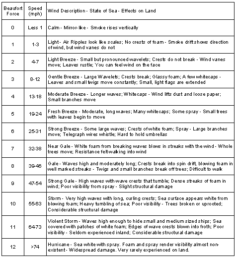
September 26 We flew today for two hours. Weather reports indicated that we might get good conditions for flying out to the east, near the Native Village of Kaktovik, also known as Barter Island, which marks the edge of the Alaska National Wildlife Refuge that has been at the center of so much controversy lately. Weather permitting we will fly as far as the Canadian border and up to 125 miles offshore on the computer-generated route. As we fly toward the area, we make several observations of conditions, such as visibility, sea state using the Beaufort Scale, ice cover, and lateral visibility. We fly along the coastline "on search" as we head for the area where we will conduct our survey today. Once in the survey area, we will fly "on transect" following the computer-generated legs. While on search around Kaktovik we see several polar bears on the beach and record the observation. Unfortunately, conditions in the area prevent us from flying the survey and we head back to Prudhoe Bay. Our today flight time is a little over two hours. We check the weather at two, hoping the forecast and reported conditions will allow us to make another flight, but we are shut down for the day. I worked out tonight at the weight room in the camp. I need to keep up my exercise routine while I am up here. The dining area is open 24-hours-a-day and the food is designed to satisfy hungry oil field workers. Sunday night is prime rib night at all the work camps across the North Slope of Alaska, a tradition which I am told goes back decades to the initial discovery and development of oil at Prudhoe Bay and the construction of the TransAlaskan Pipeline. Monday, September 26 Weather kept us grounded most of the day. At the 2:15 p.m. weather briefing, reported conditions had improved sufficiently to warrant a trip offshore to at least do a "sneak and peek" look at the area. The trouble with reported weather conditions is that they report land observations, not those over the water, and there are only one or two stations reporting for the entire area from Deadhorse to Barter Island. Past Barter Island there are no stations that report the weather. The decision to go or no go is made using a combination of reported and forecast weather, direct observations where available, and the best judgment of the pilots and the team leader. We headed for the area between Barter Island and the Canadian border, an area we know as Area 5. Flying conditions were near perfect. A brisk wind caused a great deal of swell activity along the route offshore, with lots of windwaves, swells, whitecaps, and spray. We estimated the sea state to be a Beaufort 5 or higher. These conditions make the detection of whales very difficult and we did not detect any flying the two legs of the transect. On the way back to Deadhorse we flew over the upland portion of the Alaska National Wildlife Refuge. Regardless of how you feel about potential development in the Refuge, the expansive area has a rugged, nearly desolate beauty that will be affected by development. Current proposals for development call for only 2,000 acres to be altered. This may not seem like much, but given the small surface area of drilling pads and the hopscotch and leapfrog pattern of development, quite a bit of industrialization could occur in an area that is now devoid of such activity. As we fly from Deadhorse, we see the scars left by development projects on the tundra over the last 40 years. True, the experience gained from the projects around here mean that proposed development will be less environmentally harmful and as invasive as past development. The changes may not be irreversible, but given the long-life cycles of oil and gas projects and the cumulative development over the years the character of the area will be irrevocably affected, at least in my lifetime. We saw some small caribou herds and thousands of birds. I am glad I had a chance to see the place before it might be changed |