| Port Stephens & the Myall Lakes, NSW |
 |
 |
| Another 5 or 6 days were spent sailing around Port Stephens, spending our nights in different anchorage spots or at the public jetty in Nelson Bay. Mostly the wind stayed light at 5-15 kn south easterly or north easterly. At times it reached 20 kn, but thankfully those strong 40 kn winds didn't return. One of these days we enjoyed a lovely sail close to the shoreline along Soldiers Point, to Corlette Point in Salamander Bay. Hoping the weather would remain stable overnight we picked up a swing mooring. Next morning, to our delight, we saw a very large turtle idling in the water near the boat! Apparently they are seen in the bay occassionally and are quite common in the ocean waters here. We think we were very lucky to have spotted him. We based ourselves in Nelson Bay for a couple of days. Facilities here are excellent with shops, a nice beach and a marina complex offering top quality amenities, as well as a choice of restaurants, chandlery, and other various shops. They have free visitor berths for the day but there is a charge if staying overnight. Showers are available for a small fee, and of course fuel and water are available also. The public jetty, which is where we stayed, has berthing time limits which at the time was 48 hours, but this may have changed. This jetty is very convenient to the marina, being only a couple of minutes walk away. |
| The water east of Soldiers Point to the heads is beautiful clear, turquoise blue and the beaches are white sand. We had many gloirous sails from Nelson Bay to Shoal Bay, across to Jimmys Beach and to Salamander Bay. Every day we saw large pods of dolphins which played happily around the boat, diving under the bow and darting alongside, just feet away - beautiful peaceful creatures. They looked like they were playing cat & mouse with us, but they were more likely chasing the small fish which could often be seen jumping out of the water. One spot where we saw the dolphins was near Corrie Island, on our way to the Myall River. Corrie Island is a sand island which has been described as a "wild & wonderful" overnight anchorage. This is probably because the sand island rises only about a metre or so above water level, and tucked behind it on the northern side you are sheltered safely and completely from any water movement , even if it is windy. The water here is very deep right to the shoreline and it is a perfect place for beaching the boat or anchoring overnight. This is a paradise! White sand and sparkling crystal clear water. |
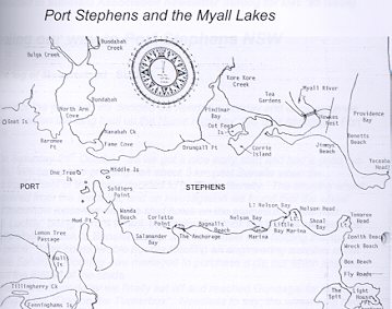
| Click for enlarged map of Port Stephens |
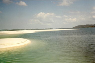 |
| Corrie Island, looking north towards Soldiers Point |
| We left this paradise a little reluctantly, hoping to have the chance of overnighting here on the return trip. Sailed up the channel into the Myall River, approaching the bridge at Tea Gardens/Hawks Nest cautiously. As always, we made sure we went under the bridge at half-tide or lower to assure good clearance, but it still looked ominious. We stopped at Tea Gardens for a few necessities and to visit the bakery for lunch! Further upriver we came to a sheltered spot near the end of Kangaroo Island where there is lots of birdlife - pelicans, ducks, eagles, and yes, even dolphins! A good place to overnight. The Myall is a lovely river. Upstream from Kangaroo Island the vegetation changes, particularly between Devil's Elbow and Cherry Tree. In some spots you feel like you are in the tropics, with huge palm groves on either side and beautiful rainforest areas. You also see the odd tin hut used by fishermen. At certain points you have to keep a close eye on the depth, but the river is well marked. |
| Roll mouse over for a view from Corrie Island to the entrance to the Pacific Ocean |
| Part 2 |
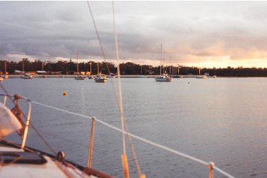 |
| Corlette Point, Salamander Bay |