| Port Stephens & the Myall Lakes, NSW |
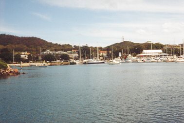
| Nelson Bay, Port Stephens, NSW - harbour and marina |
 |
 |
 |
| Roll mouse over for map |
| Discovering a little paradise..... We left Melbourne with yacht-in-tow, travelling north on the Hume Highway, and reached Gundagai for our first overnight stop. Underway early next morning, stopping at a tranquil creek in Berrima for lunch and then on to Sydney, reaching the northern suburbs by early afternoon. Port Stephens is about a 2.5 - 3 hour drive north of Sydney via the Newcastle Freeway (F3), but as we detoured to see Lake Macquarie along the way it took us a little longer, arriving at Nelson Bay Port Stephens by about 7 pm, where we overnighted in the car park alongside the marina, too tired to even think about rigging & launching. A beautiful bay with crystal clear turquoise water greeted us next morning - what a lovely sight! So much to discover. Unfortunately the wind was too strong to launch so we spent the day investigating the area and the marina. The Maritime Services Board (MSB) has an office in the marina complex and they were helpful with information on launching ramps, weather and maps. Ramps in the immediate area were all open to the very strong westerly wind which had reached 40kn at times, so we decided to drive to Lemon Tree Passage in the hope of finding a ramp which was more sheltered. The wind there was just as strong, and rigging & launching was delayed until the following morning. Facilities are good at Lemon Tree Passage - a good ramp, shops, and a marina which has a visitor's berth. We arranged storage of the car and trailer in a nearby boat sales yard, and launched by 1 pm. The wind had eased off just enough to allow safe launching, but we didn't venture far at all that afternoon, picking up a swing mooring in Lemon Tree Passage. By next morning the wind had dropped off to a 5 kn south easterly and we sailed off towards North Arm Cove, stopping for some fishing near One Tree Island where the water was extremely deep. We reached North Arm Cove in just over an hour, then sailed to Bundabah Creek at the northern end of the cove. The entrance to Bundabah Creek is very shallow, but deepens once entered. We kept close to the eastern shore near the oyster racks while entering and then followed the channel markers to the end of the oyster leases. This is a lovely sheltered spot with mangroves and an amazing amount of birdlife. Fame Cove was our choice for overnight. It is a very peaceful anchorage with high, wooded hills and deep water, sheltered from all wind except westerlies. A pod of dolphins visited us here after dark, announching their arrival with strange blowing noises and a lot of splashing! Great excitement, these were the first we had seen here and it was something we had been looking forward to. |
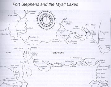 |
| Click for enlarged map of Port Stephens |