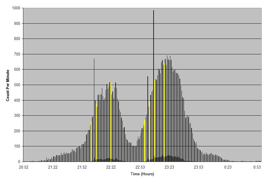
Due to the severity of the storms as they passed, we and our neighbors were in our basement. Actually, my lighting computer is located down in the basement, so we watched the screen as it displayed lightning detection in real-time. Never before in my life have I seen so much lightning. At 9pm, the storms were around 50 miles away, but I was standing outside and was amazed that the sound of thunder was one continuous and deep rumble. Also, the lightning (even at such a distance from the storms) was constant and bright enough that I could have read a newspaper by the light. So, needless to say, the amount of lightning and thunder when the storms were above us was incredible. For this reason (obviously) I refused to connect to the internet for fear of being hit by one of the million bolts of stray voltage flashing through the sky. Unfortunately this means I was unable to observe the storms via radar, so I'm only taking an educated guess at to what the above graph means.
I believe the first peak at 10:20pm (22:23) was the weakened supercell that produced the F3 tornado between 8.06pm and 8:36pm. My lightning software recognized it as being severe as it was approaching (the blue line indicating Distant Severe); after the storm got closer, the software recognized the possibilty of large hail or high wind (the yellow line). So it was still a very strong storm.
Durning this time, the National Weather Service had been issuing Tornado Warnings out ahead of these storms, which we were listening to the whole time. Immediately after the first storms started decreasing, a new Severe Thunderstorm Warning was issued for us again. This is where the second peak sky-rockets upward. From what I can discern, this is the line of thunderstorms that formed along the cold front, on the heels of the initial supercell. The software recognized three threats: Severe Thunderstorm, Possible Tornado, and then High Wind or Hail, indicated by the blue, red, and yellow lines.
I have never been in so much lightning and thunder before. It was a very interesting experience. While there was no damage that indicated a tornado in this area, the storms were obviously strong enough to produe a tornado at any time, and even did so earlier in the evening. Up until this time, I had never seen my Lightning Sensor over 800 counts per minute - the peak count was 984 strokes per minute. Subsequent storms produced higher counts, but this was mind-boggling at the time. |