 |
| The F3 Tornado of Grantsburg/Siren WI -- Maps, Radar, Links 18 June 2001 |
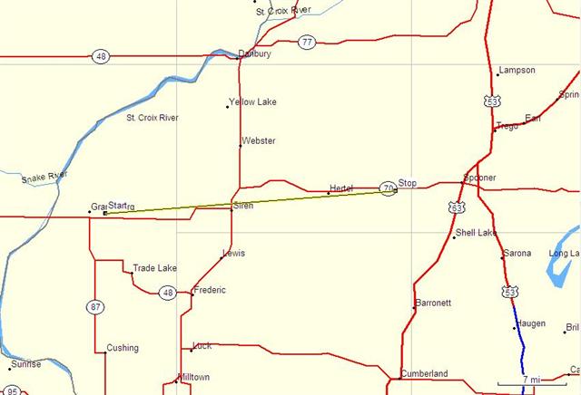
| Touchdown 8:06pm CDT Coordinates: 45d 47m N 92d 39m W 2 miles East of Grantsburg, WI |
| Dissipation 8:51pm CDT Coordinates: 45d 49m N 92d 02m W 7 miles ESE of Hertel, WI |
 |
| The supercell developed in Eastern Minnesota ahead of an approaching cold front. The cell then moved across the St. Croix River into Wisconsin. Two miles east of Grantsburg at tornado touched down at 8:06pm CDT and progressed ENE moving at about 54 mph. The tornado moved through the communities of Alpha, Falun and the City of Siren. The tornado was widest as it moved through Siren at 880 yards. This is where it produced F3 damage (winds 158-206mph). The tornado lifted three miles west of Spooner, WI, after being on the ground 30 miles. |
| The storm left $10 million dollars in damage, 16 injuries, 2 deaths. Over 400 homes and 60 businesses were destroyed. 14,000 acres of trees were leveled as the tornado moved through forest land. 15 cows were killed instantly or had to be put down. |
 |
| After the supercell stopped producing a tornado, the cell continued ENE. I live in the Park Falls area, which by plotting the path of the storm, was just north of the storm as it moved east. Tornado warnings preceded the storm. I have a whole long story about this storm at my Lightning Sensor page. |
| The NWS Duluth had a lead time of 35 minutes of warning when they issued a tornado warning for Burnett County at 7:31pm CDT. Thirty-five minutes!!! That's great! |
| LINKS |
 |
| Radar image of 7pm CDT (19:00). Supercell is just west of Burnett Co, WI. Chasers already following the storm and tornado warnings in effect. |
| Radar image of 8pm CDT (20:00). Supercell is over Burnett Co, WI and a tornado with touchdown in 6 minutes. |
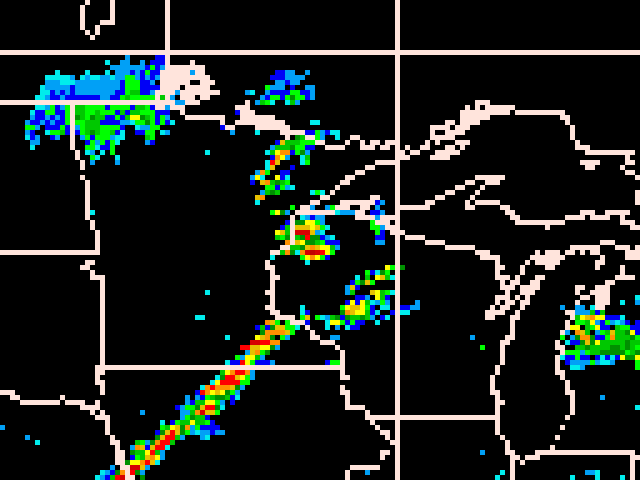 |
| Radar image of 9pm CDT (21:00). The cell is roughly over Spooner, WI but stopped producing a tornado 9 minutes ago. |
 |
 |