The southern part of the island is low with gentle hills and sandy beaches.
The byzantine city of Thaetho, was situated here, at the area where the airport is today.
Of the city only extensive sherds and demolished edifices are still to be traced today.
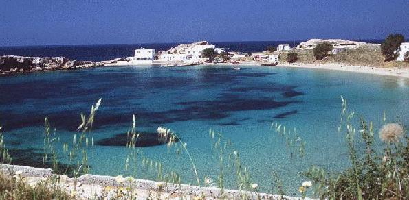
The middle southern part of the island, is marked with low stony mountains, valleys dedicated to agriculture, and long sandy beaches.
The capital of Karpathos, the town of Karpathos or Pigadia, is situated on this part of the island, on the site of the ancient greek city of Karpathos.
Another seven villages, Menetes, Arkasa, Phoeniki, Pyles, Othos Volada and Aperi, belong to this part of the island, which the Karpathiotes call Kato Horia (lower villages).
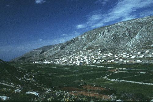
Aperi was the old capital of Karpathos, and is still the seat of the archbishop. Above the village on the top of the commanding hill of Kastro, there are the remains of medieval fortifications. A nice path to walk up the hill, begins at the village of Volada (30min).
From Volada you can also set off to conquer the island's highest peak (1215m), which bears the unusual for a mountain name of Kalolimni, meaning "Good Lake". Take the road to Othos, and before reaching the village, take the turn to the right (north), towards the plateau of Lastos. It is said that Lastos was in prehistoric times a lake, formed by the water from the springs of Kalolimni. In recored history times, Lastos has been producing excellent wine. There are still a few farmers' cottages in the platau, the "stavli" where the Karpathiotes resided during the harvest. The road continues from Lastos up the mountain to a camp of relay transmitters' installations. You can either follow the road or trace and follow goat paths. You will have reached the peak in 4 hours.
Menetes and Othos were built after the destruction by the pirates of the byzantine city of Thaetho, by the city's remaining inhabitants.
Arkasa and Phoeniki, lay at the area of the ancient greek city of Arkesea. The villages were built only as recently as the the end of last century. As it has been common practice, the builders used material of the ancient Arkesea to built their houses. The big church of Menetes was also built with ancient stones capitals and columns, which were carried on donkeys from Arkesia up to Menetes. The builders seem to have been too eager to carry the ancient material, so that 4 columns remained unused, standing now out side the church!
All the cottages of the area were also built with ancient material, but the long story of "the city for the taking" does not stop here.
Every traveller in the past several senturies has to record a diminuition.
Ludwig Ross, the Austrian archeologist who visited and described the site in 1836, speaks of the removal of 20 pillars to Samos island, for the building of the monastery of Stavros, and of a project to remove more material to the island of Kasos. Manolakakis, in his book "Karpathiaka", records the execution of this plan.
The area of Arkesea is mostly turned into fields today. The chapel of Agia Sophia marks the site of three early byzantine basilicas of large proportions (20x15m), built successively on one another, and each level having mosaic floors. Unfortunately the long story of "diminuition" of the ancient Arkesea continues today with the destruction of the fragile mosaics of the basilicas.
The ancient acropolis of Arkesea occupies the prominent peninsula projecting out of the sea. There are cyclopean walls and ancient greek walls, and foundations of public buildings, probably temples. Follow up the path from Agia Sophia.
The middle northern part of Karpathos is dominated by the island's highest mountain range, Mount Kalolimni. There are two vilages here, Mesohori and Spoa, with their sea side fishing-hamlet of Lefkos, situated at the site of another byzantine city, of considerable size. The basilica excavated in the mid '70s at Lefkos's anchorage was of unusual size, being 60m long.
Opposite Lefkos, at the strategic position of Karpathos's westernmost point, there is the islet of Xokastro. The island seems to have been a stronghold, of the frankish era. It is fortified by a medieval wall, with only one entrance. The interior of the fort is covered with piles of stones. The only structures to be distinguished are several vaulted cisterns, two of which are as large as 20x10m half hewn deep (5m) into the rock half vaulted out of the surface. The only inhabitants of the islet today are shy rabbits.
The northern part of Karpathos has the most wild nature, preserved forest, precipitous mountains, inaccessible seetlements, solitary old paths, and harsh character. Not surprisingly, it is the hikers' favourite side of Karpathos.
WALK 1.: Diafani-Elymbos. Walk up along the dry stream-bed to the west of the port of Diafani. The path that climbs up the hill side is intersected by the road leading to Elymbos. On reaching the ridge, road, path and hikers leave behind the pine-wooded stream and slopes, and face the dry rocky deep valley and mountainous area of Elymbos village. The path submerges into the valley, and emerges on Elymbos.
Tourist guides describe Elymbos as a living museum, and in many ways, Elymbos is still an open living museum, of architecture, ethnology, linguistics, musicology. Women over forty, still wear their colorful traditional robe, and seem to be doing all the work, unlike men, who only seem to be eternally involved in singing dancing and playing the local lyra.
Unfortunately the "history of diminuition" of Arkesea, is applicable to this "open museum" too. With the invasion of tourists due to the recent construction of roads and ferry boat connections, the returning of some immigrants, and most importantly the invasion of television lately, very little time remains to the complete extinction of traditional customs and way of life.
WALK 2.: Diafani-Avlona. From the saddle (see the walk above) follow either the path or the road to the left (north), which in 30min leads to the Avlona Plateau. Avlona's fields and houses are owned by the Elymbites who still cultivate the land with vine yards and cereals. About 40 of them reside here during the harvest seasons. Some of the houses are abandoned.
The houses, which are of distinguished characteristic architecture, were built here, as recently as the end of last century.
WALK 3.: Avlona-Vroukounda. At Avlona's north, the road splits. To the left (nortwest) a path continues to Vroukounda, the site of the ancient greek town of Vrykous. Don't forget to close the gates on your way down the path, to prevent the herds of sheep, goats, donkeys and mules from invading the crops at Avlona.
The city was built on a peninsula, at the island's northwest tip. It was destroyed by a strong earthqake probably during the early byzantine era. It then became yet another "city for the taking" on Karpathos. The only remains to be seen today are (in some places) the lower parts of the city's walls, several (plundered) chamber tombs, and the foundations of three basilicas.
It is widely accepted today, that the inhabitants of Vrykous, scattered throughout the island after the city's destruction and never rebuilt it, and that, later their descendants gathered at Elymbos where they built the first nucleus of the village, probably in the 16th cetury.
WALK 4.: Avlona-Tristomo Out of Avlona's north end, head to the north-northeast, to the island's northest tip. Leaving behind the wild stretches of Mount Malo, you will eventually reach the lovely, picturesque port of Tristomo. At a fast pace, 5 hours will have elapsed from the time you left Diafani.
Just to the north of Tristomo, on the strait between Saria and Karpathos, stood the renowned ancient temple of Apollo Porthmeios. Of the temple, only the foundations are to be seen today. The debate still goes on today among scolars who radicaly disagree as to which of the foundations traced in area belong to the ancient temple of Apollo.
The itinerary between Elymbos and the strait has for centuries been the Elymbites shepherds' migratory route. They used to further cross the strait walking and swimming, and release their animals on Saria to graze. Travellers of the past centuries describe the pandemonium, in their travelogs.
WALK 5.: Diafani-Vananda.
A nice easy 30min walk north of the port, will take you through pine tree grooves, to the small beach of Vananda.
50 meters inland from the beach, you will meet a small camping, inside Harry's garden.
The adventurous can cross the lush stream of Vananda with its running water,
and find the trail that leads up to Avlona plateau.
Walk 6.: Elymbos-Mount Profitis Elias (1168m)-Mount Kalolimni (1215m)-Volada
Or vice verca: Starting from Volada village you reach the the top of Kalolimni in 4 hours.
Take the road from Volada to Othos. Before entering the village take the road
to the plateau of Lastos to the north. Then head to the top either continuing on the road or following goat trails. Once on the summit, get yourself oriented, and head north to the village of Spoa or to the village of Messohori. This is the trickiest part, since the terrain is very wild, there are no trails leading anywhere except deadending on gullies or grooves of thorny bushes. From Spoa and Messohori either the road or the old mule track will eventually lead you to Elymbos in 5 hours.
Mark S. Dubin in his book "Greece on Foot" describes this track, but the area has
significantly changed since Dubin walked here. The "deminuition" hit here too, shrinking
the paths and, more importantly, the forests of the region.
Special thanks to Harry Sevdalis from Menetes, for his hospitality and the information on Menetes, Arkesea and Thaetho.
I would also like to thank Michalis the friendly proprietor of the cafe at Lefkos, and Mr. Halkias, the helpful proprietor of pension
Imeri at Lefkos (tel.:0245-71375), for their hospitality and the information on the medieval ruins of Lefkos.
Special thanks to Nader Bolouri of Artline Image Processing, 7 Aretousas Str. Iraklion (081-282474), for scanning my slides for this page.