
By clicking on the following images, you can access larger versions so that you may print them off. All these images come from Wide, S. & L. Kjellberg, 1895 "Ausgrabungen auf Kalaureia," Mittheilungen des kaiserlich deutschen archaeologischen Instituts: Athenische Abtheilung 20: 267-326. The drawings were created by S. Kristenson.
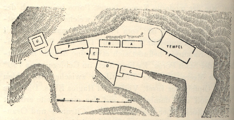
The above image gives a better idea of the topographical features of the
site. The modern road runs close the the arrows indicating the entry
path of the ancient visitor to the site. If you take the eastern road
up from Poros town (which runs by the monastery and which is the longer of
the two approaches), you will come into the site from the middle of the left
side of this map, on the flat ground that the current road sits on.
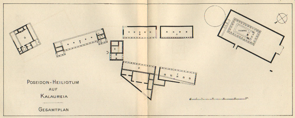
This is a more detailed plan of the site with all the buildings near the
sanctuary known to the 1895 excavators. At the far southwestern side
of the map (the left as seen here) lies "Building G". The structure,
which lies at the northeastern foot of the mountain Agios Elias, had a large
courtyard with a few bases around the interior walls. There is also
an andreion that would have been surrounded with couches for dining (ritualistic
or otherwise). Two long rooms are on either side of the courtyard.
There were a few small statuettes of Asklepios found here so this must be
the possible Asklepieon which has alternately been dubbed the Heroon of Demosthenes.
I believe this building lies on the other side of the modern road through
the site and it is probably not accessible today. The next building
one would approach entering the site, F, is a long stoa. It
had rooms at either end and W. Dorpfeld suggested that it was very similar
to the so-called Bouleterion at Mantineia. A small exedra, or
semicircular seat, lies between Stoa F and the next building, E.
The Agora: Building E has two parts, a propylaion where visitors
would enter the agora, and a portico that opened up onto the agora with two
or three rooms inside it. The agora itself is surrounded by four stoas,
two on either side. Building D sits on the right upon entering
the agora. From the front it would have looked similar to the other
stoas, but it was constructed in the shape of a trapezoid, in that the back
a number of rooms are surrounded by a wall that ends in a sharp angle.
Stoa B (see plan below) lies on the left upon entering the agora and
sits opposite Stoa/Building D. The outer walls and columns are entirely gone.
It probably was similar to Stoa A though, which lies beside it.
Stoa A is the best preserved building on the site. Foundations
for all three walls and the side that faced the agora all survive.
It was constructed with polygonal masonry and had both the Ionic and Doric
orders represented by its columns (Ionic on the inside - since they were
taller and could support the higher interior roof beams, and Doric on the
outside). Stoa C (see plan below) was opposite Stoa A (though
pointed more towards the temple, at a easily discernible angle). It
was longer but similar to Stoa A in that it also had Ionic and Doric orders.
The Temple: A polygonal wall surrounds the temple precinct, and I
believe it is still easily visible today. The north side of the precinct
drops sharply down the hillside and the wall goes right up to the edge.
The south side of the precinct faced slightly towards the agora, and it was
on this wall, about one third of the way down, that a gap in the wall provided
an entryway. The main entrance, however, was on the eastern
side and was approached by a small platform. This would have allowed
the visitor to the site to approach the temple on its front. It is
on this side of the precinct that finds from Mycenaean and Geometric periods
have been discovered. Hopefully the new excavations will place more
effort into this area and provide answers to questions about the possible
continuance of cult over a number of centuries. The temple itself sits
at the western side of the precinct. It was heavily plundered in earlier
periods and virtually nothing is left for the modern visitor to appreciate.
The temple was surrounded by a peripteros of Doric columns (6 on the front
and back and 12 along the sides). Inside the peripteros a visitor would
have walked through the pronaos which had two columns in antis.
The cella probably did not have a colonnade around its walls. There
was no opisthodemos at the rear of the temple. The temple was constructed
in the 6th century BCE (Z-style clamps and style of the tiles helped date
it). Maybe a more precise date will be possible with future excavations.
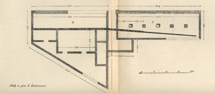
A more detailed image of Stoa C and Building B. The details on these
buildings is given above.
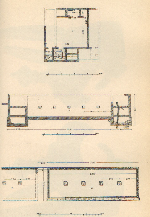
These buildings are also given a more detailed explanation above. They are:
(top) Building G; (middle) Stoa F; (bottom) Stoa A.
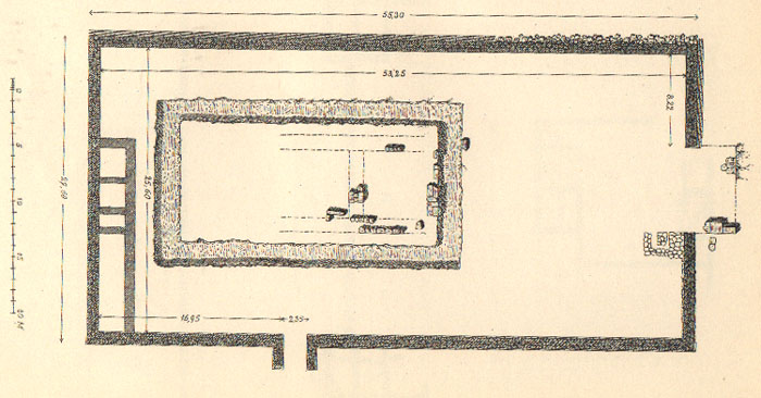
A more detailed plan of the temple and its precinct.
