
 The Island and Getting There: The island of
Poros, known as Kalauria in antiquity, is a popular tourist spot today.
But the ancient ruins that remain there are not the reasons for its popularity.
Actually, the town of Poros is the only real reason why tourists and Athenians
flock here on the weekends.
The Island and Getting There: The island of
Poros, known as Kalauria in antiquity, is a popular tourist spot today.
But the ancient ruins that remain there are not the reasons for its popularity.
Actually, the town of Poros is the only real reason why tourists and Athenians
flock here on the weekends.
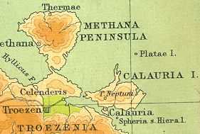
Leaving the Piraeus, on the ferry, after a couple of stops at Aegina and at modern Methana, the visitor will arrive at Poros (about 2 hours later). The island itself is about 10 kilometers from east to west and about 5 from north to south. There are two peaks on the interior of the island and a small plateau in between. Probably the most important geographical feature of the place though is its proximity to the mainland. There is only a small channel separating it from the Peloponnese, which is only about 350 meters away at its narrowest point. The name "Poros" is derived from this, meaning both a strait and a ferry.
The Island and Sites Today: The ferry arrival at Poros (the town) leaves you on the western side of the city. There are countless tourist shops with jewelry and beach gear located along the waterfront. The town wraps around the small hill in its interior and restaurants with their canvas canopies separate the buildings from the street and the water just opposite it. There are about 4,000 people living in the town of Poros and there are a number of decent places to eat. I was just there for the day and did not take a large meal there though. I have seen Pounta recommended as a good restaurant ("considered the best in town"). Unless you really have a desire to do so, you probably will not stay the night in Poros since the ferries can bring you back to Athens relatively quickly.
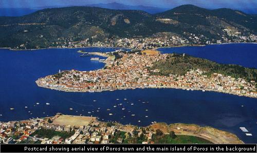 The town of Poros is itself located on a small peninsula,
once an island known as Sphaeria, jutting south from the main part of the
island. The small "canal" that cuts off the peninsula from the island
has been referred to in tour booklets as "reminiscent of Venice." But
do not be fooled. It is more like a drainage ditch than a Venetian canal.
Crossing over the bridge, the single road onto the mainland forks.
The left fork follows a path up the mountain towards the central interior
of the island (though another road does branch off to the left and follows
the coastline west for a while), and the right one immediately runs into
the village of Askeli. Askeli is a beach front collection of
restaurants, summer homes, with a few stores for good measure. The
beach is very crowded and the road lined with parked cars on weekends in
the summer. Athenians in particular visit the spot to get away from
Athens' hectic streets. But I would advise care when walking along
the single road here as well!! Plenty of people bathe in the waters
here and relax on the beach, but I have read where the waters beneath the
cliffs at nearby Methana are the most notorious breeding grounds of sharks
in all of Greece. Past Askeli a side road leads further along the coast
(the main road starts to wrap into the interior to eventually meet the one
it left) to the Monastery of Zoodokhos Piyi. I did not visit
the monastery, but it sits just off the water above a hotel.
The town of Poros is itself located on a small peninsula,
once an island known as Sphaeria, jutting south from the main part of the
island. The small "canal" that cuts off the peninsula from the island
has been referred to in tour booklets as "reminiscent of Venice." But
do not be fooled. It is more like a drainage ditch than a Venetian canal.
Crossing over the bridge, the single road onto the mainland forks.
The left fork follows a path up the mountain towards the central interior
of the island (though another road does branch off to the left and follows
the coastline west for a while), and the right one immediately runs into
the village of Askeli. Askeli is a beach front collection of
restaurants, summer homes, with a few stores for good measure. The
beach is very crowded and the road lined with parked cars on weekends in
the summer. Athenians in particular visit the spot to get away from
Athens' hectic streets. But I would advise care when walking along
the single road here as well!! Plenty of people bathe in the waters
here and relax on the beach, but I have read where the waters beneath the
cliffs at nearby Methana are the most notorious breeding grounds of sharks
in all of Greece. Past Askeli a side road leads further along the coast
(the main road starts to wrap into the interior to eventually meet the one
it left) to the Monastery of Zoodokhos Piyi. I did not visit
the monastery, but it sits just off the water above a hotel.
Though I did not realize it when I left Poros town, there
is a shuttle bus that runs across the island. Leaving Poros town, I
had already walked a few kilometers up the mountainside. The road is
pleasant enough, but an abandoned discotheque and another old house slightly
marred the view. Suddenly a bus approached and I flagged it down.
For about 50 cents I rode on a few more kilometers (it was worth it though
since I was going uphill), but the bus did not take me directly to the sanctuary.
It was only a kilometer or so further though.
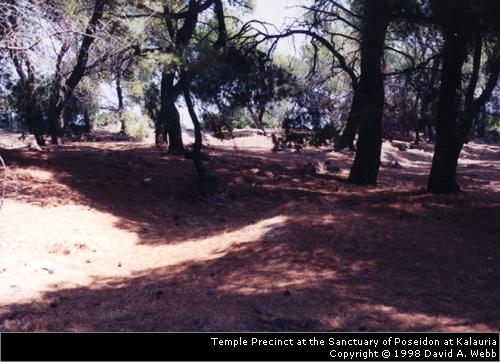
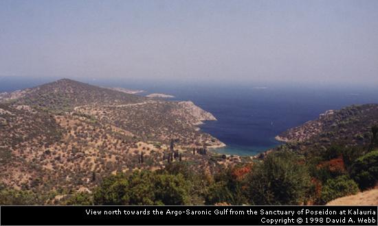
 The Ancient Site (Site Plans and Building Description!!
): The Sanctuary of Poseidon is just a few meters
off the road, which actually bisects the site. The small plateau, Palatia,
is situated on a beautiful ridge. You can clearly see back towards
the north towards the Argo-Saronic gulf (one photo on this page shows this
view), but it is harder to see back to the south. A ridge obscures
part of that view. This is the site of the headquarters of the Kalaurian
League in Classical and Hellenistic times. This league included a number
of famous city-states. Athens, Aegina, Hermione, Epidaurus, Nauplia,
Cynurian Prasiae, and Orchomenos were all members. The common bond
between the cities was not a military one or even a political one, but instead
it probably was based upon a common cult relationship between these non-Dorian
towns.
The Ancient Site (Site Plans and Building Description!!
): The Sanctuary of Poseidon is just a few meters
off the road, which actually bisects the site. The small plateau, Palatia,
is situated on a beautiful ridge. You can clearly see back towards
the north towards the Argo-Saronic gulf (one photo on this page shows this
view), but it is harder to see back to the south. A ridge obscures
part of that view. This is the site of the headquarters of the Kalaurian
League in Classical and Hellenistic times. This league included a number
of famous city-states. Athens, Aegina, Hermione, Epidaurus, Nauplia,
Cynurian Prasiae, and Orchomenos were all members. The common bond
between the cities was not a military one or even a political one, but instead
it probably was based upon a common cult relationship between these non-Dorian
towns.
Mycenaean tombs have been found near the site and dedications from the 8th century BCE as well. Cult buildings were probably first constructed in the late 6th century and continued until around 320 BCE. At this point, during the Hellenistic period, a number of structures were built, including the heroon of Demosthenes.
Demosthenes, one of the most famous Athenians of antiquity and a fierce patriot for his city, died at the sanctuary in 322 BCE. Pausanias, who visited the island a couple hundred years later, describes his death in his Guide to Greece ( 2.33.2 - from the Perseus project's English translation ):
Calaurea, they say, was sacred to Apollo of old, at the time
when Delphi was sacred to Poseidon. Legend adds that the two
gods exchanged the two places. They still say this, and quote an
oracle:--
Delos and Calaurea alike thou lovest to dwell in,
Pytho, too, the holy, and Taenarum swept by the
high winds.
At any rate, there is a holy sanctuary of Poseidon here, and it is
served by a maiden priestess until she reaches an age fit for
marriage. [2.33.3] Within the enclosure is also the tomb of
Demosthenes. His fate, and that of Homer before him, have, in
my opinion, showed most plainly how spiteful the deity is; for
Homer, after losing his sight, was, in addition to this great
affliction, cursed with a second--a poverty which drove him in
beggary to every land; while to Demosthenes it befell to
experience exile in his old age and to meet with such a violent
end. Now, although concerning him, not only others, but
Demosthenes himself, have again and again declared that
assuredly he took no part of the money that Harpalus brought
from Asia, [2.33.4] yet I must relate the circumstances of the
statement made subsequently. Shortly after Harpalus ran away
from Athens and crossed with a squadron to Crete, he was put
to death by the servants who were attending him, though some
assert that he was assassinated by Pausanias, a Macedonian.
The steward of his money fled to Rhodes, and was arrested by a
Macedonian, Philoxenus, who also had demanded Harpalus from
the Athenians. Having this slave in his power, he proceeded to
examine him, until he learned everything about such as had
allowed themselves to accept a bribe from Harpalus. On obtaining
this information he sent a dispatch to Athens, [2.33.5] in which
he gave a list of such as had taken a bribe from Harpalus, both
their names and the sums each had received. Demosthenes,
however, he never mentioned at all, although Alexander held him
in bitter hatred, and he himself had a private quarrel with him.So
Demosthenes is honored in many parts of Greece, and especially
by the dwellers in Calaurea.
 It was at Kalauria that Demosthenes, being pursued by soldiers
of Antipater (the Macedonian statesman), committed suicide rather than be
slain by his sworn enemies.
It was at Kalauria that Demosthenes, being pursued by soldiers
of Antipater (the Macedonian statesman), committed suicide rather than be
slain by his sworn enemies.
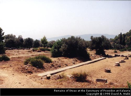
There is no readily available modern map of the site and visitors today will have trouble trying to assess the ruins. Take a look at the site plans from 1895 at the link I have included above. As I have mentioned, the modern road bisects the site, which looks at first like a poorly kept field of olive trees. There is a fence surrounding the site, but the gate should be open on the north side of the road. When you enter the site, you should be able to make out the stoas that surrounded a rectangular area. The column bases are still relatively easy to make out as are the back walls. After you pass the stoas, there is an area filled with large cedar or maybe pine trees that is roughly marked off by a small stone wall. This should be the spot where the Temple of Poseidon stood. On the opposite side of the small precinct, a terrific view out over the north part of the island can be appreciated. Until the site is better presented (there are no maps or plans for the area and the only sign is the one on the gate), it will probably remain a big pile of rubble to most people. I believe the heroon, or hero-shrine to Demosthenes, was located on the other side of the road, but if it is, it is inaccessible to tourists.
 There are some scholarly articles that have been published
on the site, but the best is more than a century old! However, in 1997,
the Swedish Institute at Athens worked on the site, with two goals for the
immediate future. The first was making a new, much needed, site plan
and the second was to open a trench just west of the peribolos wall in order
to gain an idea of where future excavations should be begun. Further,
a 3-D rendering of the sanctuary and its buildings is in the near future!
The single trench yielded remains from the 5th/4th centuries BCE as well
as LH IIIC pottery which dates to roughly the 12th century BCE. Hopefully
we will soon have a better idea of the remains of the site and maybe with
the influx of tourists into the country over the next few years, the site
will be better presented for tourists and scholars alike.
There are some scholarly articles that have been published
on the site, but the best is more than a century old! However, in 1997,
the Swedish Institute at Athens worked on the site, with two goals for the
immediate future. The first was making a new, much needed, site plan
and the second was to open a trench just west of the peribolos wall in order
to gain an idea of where future excavations should be begun. Further,
a 3-D rendering of the sanctuary and its buildings is in the near future!
The single trench yielded remains from the 5th/4th centuries BCE as well
as LH IIIC pottery which dates to roughly the 12th century BCE. Hopefully
we will soon have a better idea of the remains of the site and maybe with
the influx of tourists into the country over the next few years, the site
will be better presented for tourists and scholars alike.
 Short Bibliography:
Soon to come!
Links:
