
Eleutherai
 Even today, this classical fortress still dominates the Pass
of Gyphtokastro (as the site is alternately known). If this is the ancient
Pass of Dryoskephalai then the fortress should be the site of Eleutherai.
As the modern road climbs into Mt. Kithairon , it snakes beneath the rocky
hill which is topped by one of the largest and best preserved forts in all
of Attica (
aerial photo
).
Even today, this classical fortress still dominates the Pass
of Gyphtokastro (as the site is alternately known). If this is the ancient
Pass of Dryoskephalai then the fortress should be the site of Eleutherai.
As the modern road climbs into Mt. Kithairon , it snakes beneath the rocky
hill which is topped by one of the largest and best preserved forts in all
of Attica (
aerial photo
).
The dating of the site has been hotly contested.
Though pottery sherds dating to the fifth century B.C. have been found there,
it was most likely constructed in the first half of the fourth century, a
period that encompasses the first securely dated pottery. The style
of construction of the walls is very similar to those of Messene and seems
to suggest a close date, soon after 370 B.C. It was most likely constructed
by the Athenians to protect their borders from the neighboring Thebans.
The small catapult windows also seem to substantiate these factors since
they preclude any date 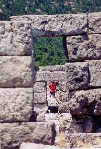 before the beginning of the fourth century. Nevertheless, the thinness
of the walls suggests a date before the latter half of the third century,
when siege equipment was developed that would have crushed walls of this
size. Other constructions and repairs of the site shows that it was
still in use a few decades after it was built as well as in the late Roman
and medieval periods.
before the beginning of the fourth century. Nevertheless, the thinness
of the walls suggests a date before the latter half of the third century,
when siege equipment was developed that would have crushed walls of this
size. Other constructions and repairs of the site shows that it was
still in use a few decades after it was built as well as in the late Roman
and medieval periods.
The view is limited up the pass and the mountains that
surround the fortress on nearly three sides surely prevented much advanced
warning, but smaller towers atop the higher hills and mountains would have
been able to signal warnings ahead to the main fortress and no force could
go through the pass without finding themselves beneath the fort's walls and
in danger.
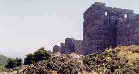
The fortress itself is still in remarkable shape.
The N wall is the best preserved section (shown at top) and it overlooks
a sharp drop down to a ravine that separates it from a much larger mountain.
There are eight rectangular towers remaining, each about 40 meters apart.
The walls that connect them are about 3.5 meters high and you can still
walk along the parapet between the towers, in a few places, if you are careful
(see accompanying photo, showing three towers, looking through their parapet
doorways). The towers themselves had wooden roofs and shutters that
could close over the windows. The upper windows are larger to allow
small catapults to fire from them but the lower ones are just for arrows.
Wooden floors on the interior allowed access on the parapet level as well
as two more levels.
Inside the fortress are the remains of numerous garrison
buildings from different periods.
The Site Today
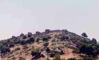 The site today is easy to find, taking the road to
Eleusis
from Athens
(22 km) and turning north towards Thebes, you should pass right by
it after an additional 30 km. Once you start climbing out of the plain
and into the Kaza pass, the fortress will appear high above the road on a
hill to the right (
photo
). A gravel road passes from the highway up to the site, but you'll
have to park across the road and further up the pass (not very far at all)
in the parking lot of a roadside store. No other structures are in sight.
Now be very careful. This road is heavily trafficked and the gravel
road leading up to the site is obstructed from motorists' view. Our
group almost had a few people run over actually. Fast cars, sharp curves,
and blind spots make this one especially dangerous. The walk up to
the site looks steep, but it's not that far. You'd regret it if you
got this far and didn't make it to the top. There are no guards or
fees here, just a lot of goat droppings.
The site today is easy to find, taking the road to
Eleusis
from Athens
(22 km) and turning north towards Thebes, you should pass right by
it after an additional 30 km. Once you start climbing out of the plain
and into the Kaza pass, the fortress will appear high above the road on a
hill to the right (
photo
). A gravel road passes from the highway up to the site, but you'll
have to park across the road and further up the pass (not very far at all)
in the parking lot of a roadside store. No other structures are in sight.
Now be very careful. This road is heavily trafficked and the gravel
road leading up to the site is obstructed from motorists' view. Our
group almost had a few people run over actually. Fast cars, sharp curves,
and blind spots make this one especially dangerous. The walk up to
the site looks steep, but it's not that far. You'd regret it if you
got this far and didn't make it to the top. There are no guards or
fees here, just a lot of goat droppings.
I would like to thank J. Matthew Harrington for his
explanations of the site and for his bibliography.
Links:
