Aigosthena
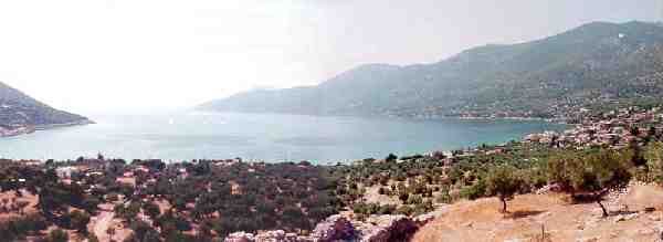 Above the modern town of Porto
Germano lies the ruins of the Megarian town of Aigosthena. They are
among the best preserved fortifications in Greece but the site's history is
not well known. The valley is surrounded by relatively steep cliffs
on almost all sides and creates a theater like setting (I hope to have a topographical
map and a site plan here soon). Once you arrive at the town, you can
park down near the water's edge and make the short walk up to the acropolis,
which has unlimited access, through the countless olive trees. You
can either walk around the S edge (gravel road) and then up the steep entrance
on the E side, or you can take the more gentle slope straight up the W side
of the hill.
Above the modern town of Porto
Germano lies the ruins of the Megarian town of Aigosthena. They are
among the best preserved fortifications in Greece but the site's history is
not well known. The valley is surrounded by relatively steep cliffs
on almost all sides and creates a theater like setting (I hope to have a topographical
map and a site plan here soon). Once you arrive at the town, you can
park down near the water's edge and make the short walk up to the acropolis,
which has unlimited access, through the countless olive trees. You
can either walk around the S edge (gravel road) and then up the steep entrance
on the E side, or you can take the more gentle slope straight up the W side
of the hill.
The Fortress
The fortifications today measure about 190m x 80m and
are half a kilometer away from the bay (
aerial photo
). The walls surrounded an acropolis but also ran all the way down
to the bay. Remains of the N circuit wall are still visible as are the
tower bases that ran along it. The S wall has not been found but it
likely lies just to the N of the river bed that passes just beneath the acropolis
and runs into the bay. The best preserved towers are located on the
acropolis though. There are still remains of eight towers visible.
The ones along the E side are in better condition than the others, but all
were damaged during earthquakes in the 1980's (compare this
photo
, with the one below, noting the absence of catapult windows in my photo).
The largest is Tower A, 8.9m square and about 20m high (not counting the
height of the acropolis of course, which makes it seem much higher).
This is the tower pictured in the photo below, sitting on the SE corner of
the citadel. All of the towers have ashlar isodomic masonry and the
walls are mostly trapezoidal with occasional polygonal blocks. The
great tower has two lower courses of limestone and the upper 30 are hard
reddish conglomerate. Some of the arrow slits are still visible, but
the upper catapult windows were not visible to me during my trip there.
The 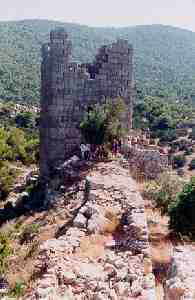 citadel has been dated from the early fourth century B.C. to the early third
century. It most likely was constructed before the town grew to any
size and so pottery dates may mislead. It was most likely constructed
during the second half of the fourth century or early in the third.
J. Ober has suggested a date of 343 B.C. This is partly due to the fact
that such a large fortress may have been constructed by Athenian initiative
during the period of Megarian-Athenian friendly relations in the 340's and
an Athenian garrison may have been installed there. The local population
probably couldn't have built it on their own and the Megarians most likely
would have had no need to build such a large fortress there.
citadel has been dated from the early fourth century B.C. to the early third
century. It most likely was constructed before the town grew to any
size and so pottery dates may mislead. It was most likely constructed
during the second half of the fourth century or early in the third.
J. Ober has suggested a date of 343 B.C. This is partly due to the fact
that such a large fortress may have been constructed by Athenian initiative
during the period of Megarian-Athenian friendly relations in the 340's and
an Athenian garrison may have been installed there. The local population
probably couldn't have built it on their own and the Megarians most likely
would have had no need to build such a large fortress there.
The Site's History
The ancient town was never very important. In fact,
it was only mentioned by a few ancient writers (Xenophon,
Pausanias 1.44.4
, and Polybius). This is also the place (before the fortress, needless
to say) where a large group of Lacedaemonians (Spartans) retreated in 371
B.C. after the Spartan defeat at Leuktra. It joined the Achaean Confederacy
when Megara joined in 243/2 B.C. and went over to Boeotia in 224. It
remained Boeotian when Megara returned to Achaea. It was an autonomous
polis under Rome. In Byzantine times the citadel was still used and
late Byzantine monastic cells are visible near the two little churches (all
inside the acropolis).
The Modern Site:
Today it is quite hard to get to Aigosthena unless you
have your own transportation. The main road from Eleusis to Thebes
can drop you off at Eleutherai (the actual ancient town, not the fortress,
which is further towards Thebes). You would still have to walk 23 km
down to Porto Germano. There are no buses that currently make this
route. Porto Germano can be swarmed by tourists during the summer months.
Weekends are particularly bad since many Athenians are getting out of the
city an heading into the countryside. The beach here, the westernmost
tip of the Gulf of Corinth, is gravel with some sand and are reputedly some
of the cleanest in Attica. I only waded in to my ankles so I can't really
vouch for this. The Rough Guide points out one hotel, the Egosthenion
(0263/41 226) but there are surely more rooms to let. They also recommend
the Psaropoula taverna, behind the first of three beaches. We ate at
a beach side taverna that was pretty decent (all four or five of them seemed
to be pretty much the same), though I cannot remember the name. Luckily
there are a couple of small stores directly between the site and the beach
for those of us who seem to be constantly needing a box of overly sweetened
fruit juice.
On your way out of the valley, take your time and enjoy
the view. Stop and take some photos of the fortress again. There
are plenty of good opportunities since the road loops around a number of times
as it climbs the hills around the site. If you look around carefully,
you may see numerous other classical towers. There are seven near Vathikhoria.
Links (also see Eleutherai on this site):