

|
PROFILE
OF CORDILLERA
 At
a Glance At
a Glance
Established
in 1987 (EO 220), with the creation of special CAR bodies ( Cordillera
Executive Board (CEB), Cordillera Regional Assembly (CRA), and the
Cordillera Bodong Administration (CBA) to administer the affairs along
economic, social and cultural developments and to prepare for the
establishment of an autonomous region.
Organic
Act for Autonomous Region lost in two (2) plebiscites (Jan 30, 1990 and
March 7, 1998).
Administrative status remains until consensus is formed
among the Cordillerans towards the type of governance that the people
envision for themselves.
Multi-sectoral consultations will be the
region's primary strategy to achieve this.
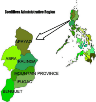
CLICK ON PROVINCE
Demographic
Characteristics
-
Number of Provinces: 6
-
Number of
Municipalities: 76
-
Number of Cities: 1
-
Number of Barangays:
1,172
-
Population: (As of
01/09/95) 1,254,838
-
Population Density: 68.6
persons per square kilometer
-
Projected Population
(Year 2000): 1,403,570
-
Average Family Income in
pesos, (1997): 112,361
-
Annual per capita
poverty threshold in pesos, (1997):12,836
-
Poverty Incidence (in percent,
1997)
Families: 42.50
Population: 50.10
-
Gross Regional Domestic
Product (Thousand Pesos, 1999)
At Current Prices: 70,633,550
At Constant 1985 Prices: 22,300,855
-
Literacy rate (in
percent, 1994): 88.80
(Source: http://www.nscb.gov.ph)

Cordillera
Administrative Region
Social Indicators
As of 15 Apr 2001 |
|
SOCIAL
INDICATORS
|
LATEST
|
PREVIOUS
|
SOURCE*
|
|
Annual Per Capita Poverty Threshold
All Areas
Urban
Rural
|
P12,836
P13,521
P12,554
(1997 ) |
P10,853
P11,054
P10,766
(1994)
|
P8,332
P8,154
P8,412
(1991)
|
TWGIS, NSCB
|
|
Incidence of Poor Families
(proportion
of poor families to the total no. of families)
All Areas
Urban
Rural
|
42.5%
13.4%
55.0%
(1997)
|
51.0%
23.9%
63.2%
(1994)
|
48.8%
24.4%
59.6%
(1991)
|
TWGIS, NSCB
|
|
Average Annual Family Income
(at
1994 Prices)
|
P92,554
(1997)
|
P74,669
(1994)
|
P75,045
(1991)
|
NSO
|
|
Average Annual Family Expenditures
(at
1994 Prices)
|
P71,601
(1997)
|
P60,317
(1994)
|
P55,746
(1991)
|
NSO
|
|
Total Population
|
1,365,220
f/
(Census
as of 01 May 2000)
|
1,254,838
(Census
as of 01 Sept. 1995)
|
1,146,191
(Census
as of 01 May 1990)
|
NSO
|
|
Population Density
(persons
per sq. km.)
|
74.6 f/
(Census
as of 01 May 2000)
|
68.6
(Census
as of 01 Sept. 1995)
|
62.7
(Census
as of 01 May 1995)
|
NSO
|
| Average
Annual Population Growth Rate |
2.2
a/
(2000-2005
Projected)
|
1.82
f/
(1995-2000
Census based)
|
1.71
(1990-1995
Census based)
|
NSO |
|
Projected Life Expectancy at Birth
(in
no. of years)
Male
Female
|
64.5
a/
69.9 a/
(2000-2005)
|
62.2
a/
67.9 a/
(1995-2000)
|
59.7
b/
65.6 b/
(1990-1995 )
|
NSO
|
|
Total Fertility Rate
(no.
of children within reproductive years)
|
3.6 a/
(2000-2005
Projected)
|
4.1 a/
(1995-2000)
|
4.6
b/
(1990-1995
)
|
NSO
|
|
Estimated Crude Birth Rate
(Births
per 1,000 population)
|
27.8 a/
(2000-2005)
|
30.6
a/
(1995-2000)
|
34.4
b/
(1990-1995)
|
NSO
|
|
Estimated Crude Death Rate
(Deaths
per 1,000 population)
|
6.5 a/
(2000-2005)
|
7.2 a/
(1995-2000)
|
8.5
b/
(1990-1995)
|
NSO
|
|
Estimated Crude Rate of Natural Increase
|
21.3 a/
(2000-2005)
|
23.4 a/
(1995-2000)
|
25.9
b/
(1990-1995)
|
NSO
|
|
Simple Literacy Rate (10
years old and over)
|
88.8
(
November 1994)
|
86.4
(
July 1989)
|
-
|
FLEMMS,
DECS-NSO
|
|
Functional Literacy Rate
(10-64 years old and over)
|
78.6
(November
1994)
|
73.7
(July
1989)
|
-
|
FLEMMS,
DECS-NSO
|
|
Enrolment in Public Elementary Schools
|
222,851
(SY
2000-2001)
|
222,450
(SY
1999-2000)
|
221,462
(SY
1998-1999)
|
DECS-CAR
|
|
Enrolment in Public Secondary Schools
|
78,869
(SY
2000-2001)
|
75,161
r/
(SY
1999-2000)
|
72,989
(SY
1998-1999)
|
DECS-CAR
|
|
Enrolment Rate, Net
(Public
Elementary School)
|
98.5
r/
(SY 1999-2000)
|
88.4
(SY
1998-1999)
|
88.7
(SY
1997-1998)
|
DECS-CAR
|
|
Enrolment Rate, Net
(Public
Secondary School)
|
72.5
r/
(SY
1999-2000)
|
46.5
(SY
1998-1999)
|
46.0
(SY
1997-1998)
|
DECS-CAR
|
|
Teacher to Pupil Ratio
(Public
Elementary School)
|
1:31
(SY
2000-2001)
|
1:31
(SY
1999-2000)
|
1:31
(SY
1998-1999)
|
DECS-CAR
|
|
Teacher to Student Ratio
(Public
Secondary School)
|
1:35
(SY
2000-2001)
|
1:34
(SY
1999-2000)
|
1:34
(SY
1998-1999)
|
DECS-CAR
|
|
Number of Barangay Health Stations
|
591
(1999)
|
522
(1998)
|
510
(1997)
|
DOH-CAR
|
|
Number of Main Health Centers
|
91
(1999)
|
88
(1998)
|
87
(1997)
|
DOH-CAR
|
|
Hospital Bed Capacity
(public
and private)
|
2,291
(1999)
|
2,342
(1998)
|
2,335
(1997)
|
DOH-CAR
|
|
Crime Incidence
|
304
(1st
Quarter 2001)
|
268
(4th
Quarter 2000)
|
304
(3
rd Quarter 2000)
|
PNP-CAR
|
|
Crime Rate
(crimes
per 100,000 population)
|
85
(2000)
|
80
(1999)
|
82
(1998)
|
PNP-CAR
|
|
Crime Solution Efficiency
|
89.1
(1st
Quarter 2001)
|
85.1
(4th
Quarter 2000)
|
88.5
(3rd
Quarter 2000)
|
PNP-CAR
|
|
Fire Incidence
|
41
(1st
Quarter 2001)
|
26
(4th
Quarter 2000)
|
23
(3rd
Quarter 2000)
|
BFP-CAR
|
|
Fire Damages to Property
(in
thousand pesos)
|
12,079.8
(1st
Quarter 2001)
|
115,764.0
(4th
Quarter 2000)
|
3,171.0
r/
(3rd
Quarter 2000)
|
BFP-CAR
|
|
Certificates of Ancestral Domain Claim
Issued
(total
land area covered, in hectares)
|
578,366
(as
of December 1998)
|
460,272
(as
of March 1998)
|
221,443
(as
of November 1996)
|
DENR-CAR
|
Notes:
a/ Based from the 1995 Census-Based National,
Regional and Provincial Population Projections (New
Volume)
b/ Based from the 1990 Philippine Population Census
r/ revised
f/ final |
|
*Sources
of Data:
|
| BFP |
Bureau of
Fire Protection |
|
DECS
|
Department
of Education, Culture and Sports |
| DENR |
Department
of Environment and Natural Resources |
|
DOH
|
Department
of Health |
|
FLEMMS
|
Functional
Literacy, Education and Mass Media Survey |
|
NSCB
|
National
Statistical Coordination Board |
|
NSO
|
National
Statistics Office |
|
PNP -
PROCAR
|
Philippine
National Police, Regional Office, Cordillera Administrative Region |
|
TWGIS
|
Technical
Working Group on Income Statistics, NSCB |
|
(Source: http://www.nscb.gov.ph)
|
CIDSS in the Region
CIDSS started its operations in the region in 1994 initially with the provinces of
Apayao, Abra, and Ifugao. It has expanded since and now covers 67 municipalities,164 (including urban poor areas) barangays in all six provinces.
| PROVINCE |
MUNICIPALITY |
BARANGAY |
FAMILIES |
| Apayao
|
Flora |
Bagutong |
189 |
| Malubibit
Norte |
192 |
| Poblacion
East |
517 |
| Pudtol |
Swan |
180 |
| Dona
Loreta |
116 |
| Capannikian |
181 |
| Sta.
Marcela |
Barocboc |
211 |
| San
Carlos |
180 |
| Malekkeg |
160 |
| Luna |
Marag
Valley |
84 |
| Salvacion |
61 |
| Cagandungan |
85 |
| Kalinga
|
Balbalan |
Pantikian |
162 |
| Gawaan |
149 |
| Talalang |
108 |
| Pasil |
Dalupa |
72 |
| Dangtalan |
83 |
| Malucsad |
96 |
| Tanudan |
Upper
Taloctoc |
241 |
| Poblacion
Mangali |
67 |
| Lubo |
404 |
| Lubuagan |
Upper
Uma |
165 |
| Tanglag |
131 |
| Lower
Uma |
* |
| Rizal |
San
Francisco |
62 |
| Kimana |
116 |
| Santor |
182 |
| Tinglayan |
Ambato-legleg |
49 |
| Bugnay |
172 |
| Old
Tinglayan |
* |
| Abra |
San
Quintin |
Labaan |
164 |
| Palang |
119 |
| Villa
Mercedes |
130 |
| Penarrubia |
Patiao |
88 |
| Malamsit |
102 |
| Sta.
Rosa |
82 |
| Bucay |
Bangbangcag |
140 |
| Tabiog |
151 |
| Palaquio |
166 |
| Villaviciosa |
Callao |
145 |
| Laplapog |
132 |
| Tuquib |
147 |
| Sallapadan |
Gangal |
158 |
| Maguyepyep |
157 |
| Bazar |
101 |
| Luba |
Ampalioc |
109 |
| Barit |
108 |
| Nagbukel-Tuquipa |
104 |
| La
Paz |
Udangan |
80 |
| Benben |
66 |
| Liguis |
154 |
| Boliney |
Poblacion |
80 |
| Dao-angan |
102 |
| Dumagas |
* |
| Bucloc |
Lingey |
106 |
| Labaan |
96 |
| Ducligan |
* |
| Daguioman |
Cabaruyan |
76 |
| Tui |
128 |
| Pikek |
* |
| Danglas |
Nagaparan |
109 |
| Padangitan |
100 |
| Abaquid |
* |
| Dolores |
Cabaroan |
108 |
| Libtec |
109 |
| Lub-lubba |
* |
| Lacub |
Buneg |
138 |
| Bacag |
50 |
| Guinguinabang |
* |
| Lagangilang |
Cayapa |
173 |
| Nagtipulan |
126 |
| Paganao |
* |
| Lagayan |
Ba-i |
160 |
| Callago |
155 |
| Pang-ot |
* |
| Langiden |
Quillat |
135 |
| Malapaao |
123 |
| Baac |
* |
| Licuan-Baay |
Bonglo |
56 |
| Lenneng |
55 |
| Subagan |
* |
| Malibcong |
Bayabas |
24 |
| Binasaran |
39 |
| Duldulao |
* |
| Manabo |
San
Ramon East |
104 |
| San
Ramon West |
98 |
| Sto.
Tomas |
* |
| Pidigan |
Sulbec |
119 |
| Alinaya |
149 |
| Immuli |
* |
| Pilar |
San
Juan West |
125 |
| South
Balioag |
92 |
|
* |
| San
Isidro |
Olo |
66 |
| Dalimag |
97 |
|
* |
| San
Juan |
Silet |
94 |
| Abualan |
110 |
| Tagaytay |
* |
| Tayum |
Basbasa |
162 |
| Budac |
218 |
| Velasco |
* |
| Tineg |
Lapat-Balantay |
55 |
| Belaat |
49 |
| Apao |
31 |
| Tubo |
Amptuagan |
74 |
| Wayangan |
64 |
| Kili |
63 |
| Ifugao
|
Aguinaldo |
Ubao |
292 |
| Monggayang |
189 |
| Awayan |
175 |
| Asipulo |
Pula |
198 |
| Antipolo |
180 |
| Liwon |
100 |
| Hingyon |
O-ong |
340 |
| Cababuyan
North |
210 |
| Mompolia |
401 |
| Banaue |
Bangaan |
168 |
| Batad |
258 |
| Anaba |
124 |
| Tinoc |
Binablayan |
209 |
| Wangwang |
108 |
| Talludan |
91 |
| Alfonso
Lista |
Dolowog |
83 |
| Namnama |
154 |
| Laya |
107 |
| Hungduan |
Bangbang |
119 |
| Nungulunan |
147 |
| Abatan |
* |
| Kiangan |
Julongan |
91 |
| Nagacadan |
141 |
| Munggayang |
* |
| Lagawe |
Jucbong |
84 |
| Dulao |
72 |
| Tupaya |
106 |
| Lamut |
Hapid |
221 |
| Pugol |
216 |
| Pieza |
* |
| Mayoyao |
Mayoyao
Proper |
100 |
| Aduyungan |
79 |
| Banhal |
* |
| Benguet |
Tublay |
Baayan |
306 |
| Tuel |
208 |
| Ambongdolan |
180 |
| Itogon |
Tuding |
1162 |
| Gumatdang |
289 |
| Ampucao |
1752 |
| Sablan |
Banangan |
296 |
| Kamog |
163 |
| Pappa |
125 |
| Kibungan |
Badeo |
169 |
| Tacadang |
412 |
| Lubo |
166 |
| Atok |
Topdak |
382 |
| Abiang |
314 |
| Pasdong |
147 |
| Bakun |
Bagu |
163 |
| Dalipey |
390 |
| Sinacbat |
* |
| Bokod |
Pito |
128 |
| Bobok-Bisal |
242 |
| Ekip |
145 |
| Bugias |
Bacukulungan
Norte |
367 |
| Amlimay |
403 |
| Poblacion |
* |
| Kabayan |
Pacso |
187 |
| Duacan |
139 |
| Anchokey |
61 |
| Kapangan |
Gaswiling |
172 |
| Boklaoan |
108 |
| Sagubo |
* |
| Mt.
Province
|
Sagada |
Fedelisan |
92 |
| Pide |
90 |
| Tanulong |
96 |
| Besao |
Gueday |
159 |
| Agawa |
79 |
| Ambagiw |
59 |
| Sadanga |
Anabel |
120 |
| Betwagan |
355 |
| Bekigan |
118 |
| Tadian |
Dacudac |
204 |
| Cadad-anan |
122 |
| Lenga |
114 |
| Bauko |
Sadsadan |
110 |
| Manamon
Norte |
101 |
| Maba-ay |
52 |
| Barlig |
Ogo-og |
103 |
| Kaleo |
140 |
| Lias
Kanluran |
105 |
| Bontoc |
Balili |
67 |
| Bontoc
Ili |
70 |
| Tocucan |
152 |
| Natonin |
Alunogan |
142 |
| Pudo |
138 |
| Sta.
Isabel |
231 |
| Paracelis |
Bantay |
106 |
| Anonat |
65 |
| Buringal
Sitio Makilo |
75 |
| Sabangan |
Gayang |
90 |
| Napua |
112 |
| Namatic |
166 |
|
URBAN POOR
BARANGAYS |
| Benguet |
La
Trinidad |
Beckel |
243 |
| Apayao |
Kabugao |
Poblacion |
* |
| Ifugao |
Lagawe |
Buhawit |
* |
*data
not available
|