Cycling Articles
All of the elevation data was collected with a Garmin Edge 305.
Although the Garmin is very accurate and performs consistently, it
is possible that some readings will be off. It's easy to measure the
accuracy by monitoring the total feet climbed and the
total feet descended. If you start and finish from the same point then
these two numbers should be the same. The typical accuracy has ranged
from 15 to 30 feet. I noticed that the grades displayed on the Garmin
do not match what is displayed in the software. My guess is that the
value displayed on the Garmin is the instaneous grade and the value
shown in the software is some sort of average over a predefined
distance. Sometimes the peak elevations do not match when I come back
to the same point. For example, if I climb one side of a mountain,
descend down the other, and then come back the side I just descended,
the elevation may be off by 40 feet. That's really not too bad because
it still results in a error of less than 1% if I'm already at 6500+
feet! So, for the sake of consistency, I will always go by what the
Garmin tells me even if I know that I could be a little off. After all,
if I get two elevation readings after returning to the same spot then
how do I know which one I should ignore?
If you have some data for these climbs and want to
share then don't hesitate to send me an e-mail at
[email protected].
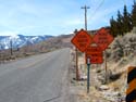
Climbs In, Around, and Near the Carson Tahoe Area
The Carson Tahoe Area is filled with lots of beautiful roads to climb and explore. I have made little slide show
presentations of my favorite roads. Each presentation is in Adobe PDF
format. A free viewer is available from Adobe's website at
www.adobe.com. Click on the thumbnail to access each presentation. Feel
free to drop me an e-mail if you have any comments on the files or if
you just want to say hello. I hope you enjoy riding these roads as much
as I do!
Difficulty: The climbs around here are usually not very steep but they
can be somewhat long. None of these climbs are very twisty or
technical. However, the elevation can get to most people. Most climbs
start at around 4500 feet and can get as high as 8900 feet. For someone
who may be used to 1000 feet elevation or even sea level, breathing may
be a little more difficult. As a side note, there are some hiking and
mountain biking trails in the area that can reach 10000+ feet. The
wind, dry environment, and strong winds can make a simple 4% gradient
feel like 8% or more. Please note that I give the average grade for the
entire road. There are usually some incredibly steep sections in the
climbs so be prepared.
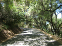
General Road Info: The roads in and around the area are usually in good
condition. There aren't too many pot holes, cracks, or bumps. You won't
find too many thorns flying around either. However, there is usually
quite a bit of sand, gravel, and rock on the shoulders. It gets kicked
off by the cars. The rocks are pretty sharp and can easily puncture the
side of a tire. Always carry a spare tube and a patch kit. It can get
pretty remote pretty fast and you don't want to wind up stuck in the
middle of nowhere. Cell phones work well but there may be some
"dead" spots further away from the centers of the nearby towns. Toilets
are scarce so find a spot and go quick. Be sure to carry enough food
and water for the entire ride. Many of the convenience stores in the
areas won't have PowerBars, GU gels, etc but they will have bottled
water.
General Weather Info: If there is one thing that anyone can count on,
it's wind. A strong eastward bound wind is common around the area as it
comes in from the tops of the mountains. Start your ride early in the
morning and you'll most likely miss the strongest gusts. Temperatures
can be cool and chilly in the morning but soar to 100+ degrees F in the
afternoon. Add a humidity level of only 5% to 10% and it's easy to
become dehydrated very quickly. Again, start early and you won't
vaporize as much during the day.
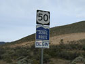
General Traffic Info: The area is not densely populated but there are
very few main roads. You'll find yourself on Hwys 395 and 50 for at
least some portion of your ride (or drive to the start). These are
highways so the speed limit can get as high as 55 MPH or even 70 MPH!
That gives the impression that the traffic is pretty bad. However, it
all disappears (literally) once you take that left or right hand turn
to get to the climb. Just don't compete against the traffic. Stay in
the shoulder. You won't win against a 5000 pound truck speeding down
the highway. Start early in the morning to minimize the chances of a contest.
|
Road |
Date |
Vital Statistics |
|
Old Clear Creek Road |
10-Mar-2007 |
Length: 4.23 miles
Starting Elevation: 4479 feet
Ending Elevation: 5751 feet
Total Ascent: 971 feet
Average Grade: 4.3% |
 |
Kings Canyon |
17-Mar-2007 |
Length: 2.69 miles
Starting Elevation: 4683 feet
Ending Elevation: 5359 feet
Total Ascent: 676 feet
Average Grade: 4.8% |
 |
Timberline Road |
24-March-2007 |
Length: 2.31 miles
Starting Elevation: 4809 feet
Ending Elevation 5544 feet
Total Ascent: 735 feet
Average Grade: 6.0% |
 |
Combs Canyon Road |
25-March-2007 |
Length: 2.32 miles
Starting Elevation: 4781 feet
Ending Elevation: 5421 feet
Total Ascent: 640 feet
Average Grade: 5.2% |
 |
Emmigrant Trail |
31-March-2007 |
North Side
Length: 3.01 miles
Starting Elevation: 5072 feet
Ending Elevation: 5690 feet
Total Ascent: 618 feet
Average Grade: 3.9%
South Side
Length: 0.30 miles
Starting Elevation: 5630 feet
Ending Elevation: 5690 feet
Total Ascent: 60 feet
Average Grade: 3.8% |
 |
Kingsbury Grade |
07-April-2007 |
East Side
Length: 7.90 miles
Starting Elevation: 4783 feet
Ending Elevation: 7299 feet
Total Ascent 2516 feet
Average Grade: 6.0%
West Side
Length: 3.12 miles
Starting Elevation: 6333 feet
Ending Elevation: 7336 feet
Total Ascent: 1003 feet
Average Grade: 6.1% |
 |
Highways 341 and 342 to Geiger Summit through Virginia City |
21-April-2007 |
Length: 10.84 miles
Starting Elevation: 4761 feet
Ending Elevation: 6802 feet
Total Ascent: 2041 feet
Average Grade: 3.6% |
 |
Highway 341 (Truck Route) to Geiger Summit through Virginia City |
28-April-2007 |
Length: 12.24 miles
Starting Elevation: 4767 feet
Ending Elevation: 6761 feet
Total Ascent 1994 feet
Average Grade: 3.1 % |
 |
Six Mile Canyon Road |
06-May-2007 |
Length: 7.92 miles
Starting Elevation: 4315 feet
Ending Elevation: 6121 feet
Total Ascent: 1806 feet
Average Grade: 4.3% |
 |
Geiger Grade |
12-May-2007 |
Length: 9.22 miles
Starting Elevation: 4590 feet
Ending Elevation: 6752 feet
Total Ascent: 2162 feet
Average Grade: 4.4% |
|
Highway 50 from Highway 395 to Spooner Summit |
20-May-2007 |
Length: 9.10 miles
Starting Elevation: 4755 feet
Ending Elevation: 7081 feet
Total Ascent: 2326 feet
Average Grade: 4.8% |
 |
Ebbetts Pass from Hwy 89 - The Third Death Ride Pass |
28-May-2007 |
Length: 13.02 miles
Starting Elevation: 5713 feet
Ending Elevation 8676 feet
Total Ascent 2963 feet
Average Grade: 4.3% |
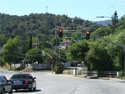
Climbs In, Around, and Near San Jose
I grew up in San Jose, California and
had the joy of beginning my passion for cycling in the Bay Area. My
father and I rode on many roads and climbed many a steep slope in the
80s and 90s. After getting married, my wife and I moved away from the
area. The traffic was too hectic and the cost of living was too high.
Today's Bay Area is much different than what it was 20-some-odd years
ago. I still have the good memories of my rides with my father and
every time I go back to visit my family I take my bicycle with me.
Now I can take my Garmin and capture some road profiles. Here are some
presentations of my favorite climbs.
Difficulty: The Bay Area sits at a very low elevation. I used to live
in a neighborhood that sat at 270 feet above sea level. If you're
coming from a high elevation area such as the Carson/Tahoe Valley then
you will feel like Superman. Oxygen is plentiful. You won't tire as
easily. The summits do not sit at the same elevation as they would in
the Carson/Tahoe area. Despite this, the roads can be very difficult to
climb. Gradients can easily kick up to 8% or even 10% and stay there.
Don't assume low elevation automatically equates to easy climbing.
However, the flip side is true in some cases. Some of the roads are
very old and were designed for horse drawn carriages and old cars. The
climb to Mount Hamilton is a classic example where the road is long but
very gentle. There is an observatory at the peak and the materials used
to build the observatory were taken up horses.
General Road Info: Be prepared for a shock here. Many of the roads are
rough and beat up. It was once paved very well but, unfortunately,
after 20+ years of high traffic and almost no maintainence the surface
is no longer even or smooth. California is a bankrupt state running on
fumes. The cities don't fare much better. There just isn't enough money
to maintain the roads today. You might want to have a set of good
touring tires and lower the pressure slightly to absord the shocks.
General Weather Info: In general, the weather is very mild and very
consistent. You won't see sudden shifts (up ot down) in temperature. It
won't snow during the winter although it can get a little cold.
Likewise, it will get hot during the summer but you won't have very
many days of extreme heat if it all. This mild weather is the number
one reason why so many people move to the area in addition to the
almost infinite job opportunities. Spring and autumn are absolutely the
best times to ride. It can get a little humid and almost muggy
sometimes but a Pacific breeze can clear that up pretty quick. Watch
out for smog alerts - especially during the summer. The air quality has
been known to drop when the temperatures rise.
General Traffic Info: Don't try fooling yourself. The Bay Area is a
large congested area. No matter where you go there will
be traffic. The only question is how much. San Jose alone has over
one million people living in it and the surrounding cities are not
wasting any time in trying to catch up. In some parts the roads are
just too dangerous to ride. For as lame as it sounds, you may want to
use the sidewalk in some places. Everyone wants to commute on their big
SUV or lifted truck. The lifestyle is a bit more hectic than in a small
town and the driving habits will reflect it. People are nt afraid to
speed and accelerate wildly. I would suggest starting early and
sticking to weekends only. Sunday is probably the best time to ride.
There are some pockets of low population density and low traffic but
they are getting harder and harder to find.
|
Road |
Date |
Vital Statistics |
 |
Hicks Rd (Camden Side and Alamitos Side) |
16-June-2007 |
Camden Side
Length: 6.23 miles
Starting Elevation: 270 feet
Endiing Elevation: 1372 feet
Total Ascent: 1102 feet
Average Grade: 3.35%
Alamitos Side:
Length: 1.67 miles
Starting Elevation: 605 feet
Ending Elevation: 1346 feet
Total Ascent: 741 feet
Average Grade: 8.40% |
 |
Reynolds (off of Hicks Rd - Camden Side) |
16-June 2007 |
Length: 1.16 miles
Starting Elevation: 439 feet
Ending Elevation: 1078 feet
Total Ascent: 639 feet
Average Grade: 10.43% |
 |
Phesant (off of Hicks Rd - Camden Side) |
16-June-2007 |
Length: 0.53 miles
Starting Elevation: 379 feet
Ending Elevation: 601 feet
Total Ascent: 222 feet
Average Grade: 7.93% |
|
Wagner (off of Hicks Rd - Camden Side) |
16-June-2007 |
Length: 0.54 miles
Starting Elevation: 333 feet
Ending Elevation: 507 feet
Total Ascent: 174 feet
Average Grade: 6.10% |