 Explanation is provided elsewhere about above map, made as the speculative viewpoint of a "map maker". Click on the last URL address, provided below, to go to another FAIR address. Remember it is not DOGMATIC, or usual LDS understanding, but only the "personal view, speculations" from just a plain person.
What is "top secret" linking the Book of Mormon and above map? Should it show the "central land" in which most of the events took place envolving NEPHITES, LAMANITES, JAREDITES, ZARAHemlites, etc.? What is the MYSTERY that made such geographic location, the "central land", so obscure? When in fact so clear, abundant and free information is available?
MYSTERY is related to a situation like having good and reliable topographic landmark(s), as CUMORAH HILL, and data, and not making use of them... In fact this is the HUGE MYSTERY linked to Book of Mormon. Why, quite like a VEIL, was placed over such central land, and all by ourselves and during so long time, to not see?
Explanation is provided elsewhere about above map, made as the speculative viewpoint of a "map maker". Click on the last URL address, provided below, to go to another FAIR address. Remember it is not DOGMATIC, or usual LDS understanding, but only the "personal view, speculations" from just a plain person.
What is "top secret" linking the Book of Mormon and above map? Should it show the "central land" in which most of the events took place envolving NEPHITES, LAMANITES, JAREDITES, ZARAHemlites, etc.? What is the MYSTERY that made such geographic location, the "central land", so obscure? When in fact so clear, abundant and free information is available?
MYSTERY is related to a situation like having good and reliable topographic landmark(s), as CUMORAH HILL, and data, and not making use of them... In fact this is the HUGE MYSTERY linked to Book of Mormon. Why, quite like a VEIL, was placed over such central land, and all by ourselves and during so long time, to not see?.
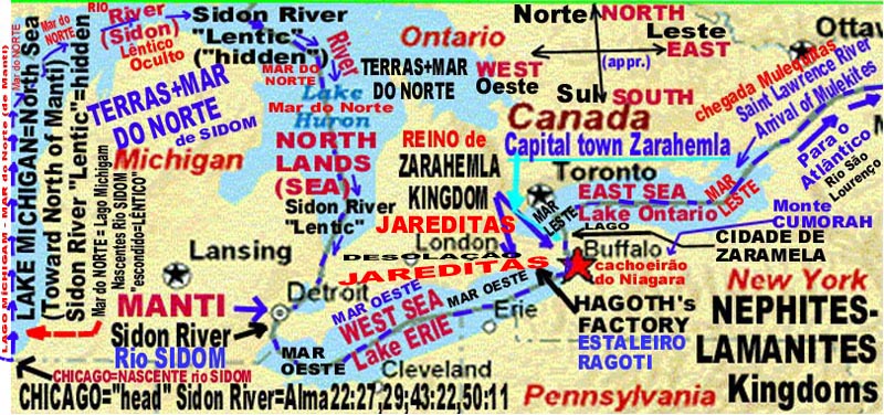
Probably some my sites, that are mainly related to TOPOGRAPHY and GEOGRAPHY, may will help you understand a problem that is not RELIGIOUS in NATURE, but related to TECHNOLOGY (as is related to make Good Topographic Maps, reliable, not biased) and to make practical use of the IMPLICIT MAPS that are inside (within) Book of Mormon , with so good topographic data provided and good descriptions of the land being mapped, as if us reading old little books topographers wrote on data in field to prepare maps in offices. In the past I was the technical director and also shareholder of an important Brazilian technical mapping co., making good and reliable maps (using field topography data and precision air-photos), ranging from farm lands, roads and up to huge towns (here with high precision geodesic system, for engineering purposes, in scale up to 1:1,000... Book of Mormon can be read, if not biased (tehnically) in many places, as a topographer providing good data to make future good maps. See the nice topographic description of going from Jerusalem to SHAZER (in fact is CHASER, in Nephitic, SHAZER is phonetically in English) and then to BOUNTIFUL and sailing to America: it is "amazing" nobody yet presented such so simple corresponding map... http://www.fairboards.org/index.php?showtopic=16685 SHALOM (it is lacking in Lebanon, Joel 3:6, greatest part of Lebaneses are now living in Brazil, as if expontaneous deportation). http://www.geocities.com/celsosavelligomes/ESTREITO-RAGOTI-BUFALO-AMNIU.jpg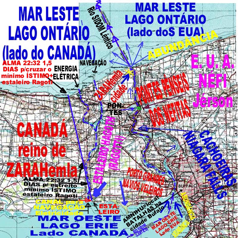 In this map you can see THE MOST NARROW of the NECK" of the ISTHMUS of ZARAHemla (in geography is like the Isthmus of PANAMA...), which separates the EAST SEA (on top, it is the LAKE ONTARIO, see previous map, above, showing almost all Great Lakes region...) and the WEST SEA (on bottom, it is LAKE ERIE) and unite the great mass of lands on NORTH (which is CANADA, ZARAHemla and JAREDITES lands) from the great mass of lands on SOUTH (which is USA, NEPHI's lands). You MUST have in mind that North in this map is toward LEFT (not to top): it is not made according usual maps presentation! Where is ABUNDANCE: it is in the shoreline of NEPHI's land, thus in the SOUTH border of Lake Erie and Lake Ontario, which means the right sided shore lines (it is written in Portuguese: ABUNDANCIA = ABUNDANCE). It is a land plenty of TREES to be used as cosntruction material (for homes, temples, public buildings, military forts, etc.). In the opposite margins, ZARAHemla's kingdom, was the limit of JAREDITIC lands, with borders DESOLATED = EMPTY of VEGETATION (it is not "sandy desert land, hot, without water, etc".
In the right side you can see the pathway of of SIDON RIVER (as LENTHIC RIVER, hidden) and then into SIDON RIVER = start of NIAGARA RIVER (in LOTIC condition, possible to see flow of a visible river (which started as LENTHIC RIVER SIDON in CHICAGO, as "head, spring, source"), as end of WEST SEA = LAKE ERIE turning into the RIVER SIDON (in LOTIC condition, visible flow) = NIAGARA RIVER. You can see such LOTIC flow condition (see DICTIONARY for LENTHIC and LOTIC...). Moving from down to upper right part of map, you can see where it is NIAGARA FALLS (at the very right margin it is written "CACHOEIRAS / NIAGARA FALLS" and an arrow line points to the FALLS). Just a little above you can see two short cross lines, in brilliant Green color, crossing the NIAGARA RIVER, in two "huge suspended bridges" (they were located using NASA high precision pictures given to quite like spying work in military forts place; then I got very high precision USGS maps...).
The NIAGARA RIVER ends (discharges) upward in LAKE ONTARIO = EAST SEA, and in the left place of such very discharge place, is Fort St. Jorge (Canada) and there it was located ZARAHEMLA (a big yellow star is over it), the capital town of kingdom ZARAHEMLA. You can see the transformation of RIVER SIDON (LOTIC) into RIVER SIDON (LENTHIC condition), and the flowing path accross Lake Ontario, to become, at the end of Lake Ontario, into RIVER SIDON (LOTIC condition) = RIVER SAINT LAWRENCE, which flows long to discharge into ATLANTIC OCEAN.
Let us return to the lower part of above map. As you move left of BUFFALLO town (near it took place the battle AMNIHU for such NEPHI's lands), through the MOUTH of NIAGARA RIVER, you are to see the old harbor of Zarahemla for huge CARGO SAILSHPS (it is written "PORTO NAVIOS GRANDES VELEIROS" and an arrow points to it. Going next to left, you are to see written "ESTALEIRO", from inside LAKE ERIE, and also "ESTALEIRO HAGOTH" and also an arrow poiting to the same point in shore line. HAGOTH's sail-ship factory is at the entrance (MOUTH) of the HUGE NAVIGATION CHANNEL, which crosses the MOST NARROW of the NECK of ISTHMUS land of ZARAHEMLA. You can see such CHANNEL going from bottom (where receives water from LAKE ERIE) to the top, where it split into two channels, as you can see both discharging on LAKE ONTARIO: one is for ELECTRICITY POWER GENERATION (left) and the other is for TRAFFIC of VERY HUGE CARGO SHIPS, transporting GRAINS from CHICAGO CORN-BELT to EUROPE and to the WORLD.
You can see such NAVIGATION CHANNEL is almost at the shortest line, from HAGOTH factory of huge SAIL-SHIPS, at the shoreline of WEST SEA (LAKE ERIE), to the shoreline of EAST SEA (LAKE ONTARIO), in a distance which is 1.5 days walk of soldier men (as I checked with modern Army officers and with Internet data on walking distances): a nice distance for noways 1.5 day walk with an equiped soldier. It is the ALMA 22:32 geographic place and condition. .
Posted on Jul 24 2006, 12:40 PM
The start of EXPLANATION for the MYSTERYES related to the BOOK of MORMON are in this following FAIR message:
My Webpage on http://www.fairboards.org/index.php?showtopic=16685
REMEMBER that having just one TOPOGRAPHYC LANDMARK, and knowing where is the north (azimuth), it is quite easy to restore a map of one land described by topographic old measurements/descriptions and/or distances and/or angles. One big LANDMARK is the CUMORAH HILL, itself, and very obvious. BUT, there are OTHERS, that I was able to discover and disclose, while drawing the maps of Book of Mormon for "main land region", starting from CUMORAH HILL: like I found Indian names (including one Jew tribe alive, of Juddah's, in Canada = the Onondada = Onan + 'dadah'); Indians names having the corresponding names in Book of Mormon, some a little corrupted spelling) and/or geographic features described in Book of Mormon (as RIPLAH) and in nowadays conditions for them (as position and names in modern and precise USGS maps, air-photos, satellite pictures, OLD MAPS of such REGION, descriptions from hystorians/Museums, etc.).
Such PROCEDURES/means we use in converting into modern Land registers the old Registrations, for notary: very old documents, some very difficult to restore in details (as river/roads may have changed of position, fences, etc.). Thus such type of "investigation, with some guess as if from detectives", must be followed with Book of Mormons to have the corresponding modern limits of a modern map "worth" to the implicit map included in the Book of Mormon".
SHALOM
Probably some my sites, that are mainly related to TOPOGRAPHY and GEOGRAPHY, may will help you understand a problem that is not RELIGIOUS in NATURE, but related to TECHNOLOGY (as is related to make Good Topographic Maps, reliable, not biased) and to make practical use of the IMPLICIT MAPS that are inside (within) Book of Mormon , with so good topographic data provided and good descriptions of the land being mapped, as if us reading old little books topographers wrote on data in field to prepare maps in offices.
In the past I was the technical director and also shareholder of an important Brazilian technical mapping co., making good and reliable maps (using field topography data and precision air-photos), ranging from farm lands, roads and up to huge towns (here with high precision geodesic system, for engineering purposes, in scale up to 1:1,000...
Book of Mormon can be read, if not biased (tehnically) in many places, as a topographer providing good data to make future good maps. See the nice topographic description of going from Jerusalem to SHAZER (in fact is CHASER, in Nephitic, SHAZER is phonetically in English) and then to BOUNTIFUL and sailing to America: it is "amazing" nobody yet presented such so simple corresponding map...
http://www.fairboards.org/index.php?showtopic=16685
SHALOM (it is lacking in Lebanon, Joel 3:6, greatest part of Lebaneses are now living in Brazil, as if expontaneous deportation).
http://www.geocities.com/celsosavelligomes/ESTREITO-RAGOTI-BUFALO-AMNIU.jpg
In this map you can see THE MOST NARROW of the NECK" of the ISTHMUS of ZARAHemla (in geography is like the Isthmus of PANAMA... http://www.answers.com/topic/isthmus), which separates the EAST SEA (on top, it is the LAKE ONTARIO, see previous map, above, showing almost all Great Lakes region...) and the WEST SEA (on bottom, it is LAKE ERIE) and unite the great mass of lands on NORTH (which is CANADA, ZARAHemla and JAREDITES lands) from the great mass of lands on SOUTH (which is USA, NEPHI's lands). You MUST have in mind that North in this map is toward LEFT (not to top): it is not made according usual maps presentation! Where is "BOUNTIFUL" (ABUNDANCE="abundancia" in Latin languages): it is in the shoreline of NEPHI's land, thus in the SOUTH border of Lake Erie and Lake Ontario, which means the right sided shore lines (it is written in Portuguese: "ABUNDANCIA" = BOUNTIFUL). It is a land plenty of TREES to be used as cosntruction material (for homes, temples, public buildings, military forts, etc.). In the opposite margins, ZARAHemla's kingdom, was the limit of JAREDITIC lands, with borders DESOLATED = "EMPT" of something, in this case of VEGETATION (it is not "sandy desert land, hot, without water, etc".
In the right side you can see the pathway of of SIDON RIVER (as LENTHIC RIVER, hidden) and then into SIDON RIVER = start of NIAGARA RIVER (in LOTIC condition, possible to see flow of a visible river (which started as LENTHIC RIVER SIDON in CHICAGO, as "head, spring, source"), as end of WEST SEA = LAKE ERIE turning into the RIVER SIDON (in LOTIC condition, visible flow) = NIAGARA RIVER. You can see such LOTIC flow condition (see DICTIONARY for LENTHIC and LOTIC...). Moving from down to upper right part of map, you can see where it is NIAGARA FALLS (at the very right margin it is written "CACHOEIRAS / NIAGARA FALLS" and an arrow line points to the FALLS). Just a little above you can see two short cross lines, in brilliant Green color, crossing the NIAGARA RIVER, in two "huge suspended bridges" (they were located using NASA high precision pictures given to quite like spying work in military forts place; then I got very high precision USGS maps...).
The NIAGARA RIVER ends (discharges) upward in LAKE (=lago) ONTARIO = EAST SEA, and in the left place of such very discharge place, is Fort St. Jorge (Canada) and there it was located ZARAHEMLA (a big yellow star is over it), the capital town of kingdom ZARAHEMLA. You can see the transformation of RIVER SIDON (LOTIC) into RIVER SIDON (LENTHIC condition), and the flowing path accross Lake Ontario, to become, at the end of Lake Ontario, into RIVER SIDON (LOTIC condition) = RIVER SAINT LAWRENCE, which flows long to discharge into ATLANTIC OCEAN.
Let us return to the lower part of above map. As you move left of BUFFALLO town (near it took place the battle AMNIHU for such NEPHI's lands), through the MOUTH of NIAGARA RIVER, you are to see the old harbor of Zarahemla for huge CARGO SAILSHPS (it is written "PORTO NAVIOS GRANDES VELEIROS" and an arrow points to it. Going next to left, you are to see written "ESTALEIRO", from inside LAKE ERIE, and also "ESTALEIRO HAGOTH" and also an arrow poiting to the same point in shore line. HAGOTH's sail-ship factory is at the entrance (MOUTH) of the HUGE NAVIGATION CHANNEL, which crosses the MOST NARROW of the NECK of ISTHMUS land of ZARAHEMLA. You can see such CHANNEL going from bottom (where receives water from LAKE ERIE) to the top, where it split into two channels, as you can see both discharging on LAKE ONTARIO: one is for ELECTRICITY POWER GENERATION (left) and the other is for TRAFFIC of VERY HUGE CARGO SHIPS, transporting GRAINS from CHICAGO CORN-BELT to EUROPE and to the WORLD.
You can see such NAVIGATION CHANNEL is almost at the shortest line, from HAGOTH factory of huge SAIL-SHIPS, at the shoreline of WEST SEA (LAKE ERIE), to the shoreline of EAST SEA (LAKE ONTARIO), in a distance which is 1.5 days walk of soldier men (as I checked with modern Army officers and with Internet data on walking distances): a nice distance for noways 1.5 day walk with an equiped soldier. It is the ALMA 22:32 geographic place and condition.
http://www.fairboards.org/index.php?showforum=11
In this map you can see THE MOST NARROW of the NECK" of the ISTHMUS of ZARAHemla (in geography is like the Isthmus of PANAMA...), which separates the EAST SEA (on top, it is the LAKE ONTARIO, see previous map, above, showing almost all Great Lakes region...) and the WEST SEA (on bottom, it is LAKE ERIE) and unite the great mass of lands on NORTH (which is CANADA, ZARAHemla and JAREDITES lands) from the great mass of lands on SOUTH (which is USA, NEPHI's lands). You MUST have in mind that North in this map is toward LEFT (not to top): it is not made according usual maps presentation! Where is ABUNDANCE: it is in the shoreline of NEPHI's land, thus in the SOUTH border of Lake Erie and Lake Ontario, which means the right sided shore lines (it is written in Portuguese: ABUNDANCIA = ABUNDANCE). It is a land plenty of TREES to be used as cosntruction material (for homes, temples, public buildings, military forts, etc.). In the opposite margins, ZARAHemla's kingdom, was the limit of JAREDITIC lands, with borders DESOLATED = EMPTY of VEGETATION (it is not "sandy desert land, hot, without water, etc".
In the right side you can see the pathway of of SIDON RIVER (as LENTHIC RIVER, hidden) and then into SIDON RIVER = start of NIAGARA RIVER (in LOTIC condition, possible to see flow of a visible river (which started as LENTHIC RIVER SIDON in CHICAGO, as "head, spring, source"), as end of WEST SEA = LAKE ERIE turning into the RIVER SIDON (in LOTIC condition, visible flow) = NIAGARA RIVER. You can see such LOTIC flow condition (see DICTIONARY for LENTHIC and LOTIC...). Moving from down to upper right part of map, you can see where it is NIAGARA FALLS (at the very right margin it is written "CACHOEIRAS / NIAGARA FALLS" and an arrow line points to the FALLS). Just a little above you can see two short cross lines, in brilliant Green color, crossing the NIAGARA RIVER, in two "huge suspended bridges" (they were located using NASA high precision pictures given to quite like spying work in military forts place; then I got very high precision USGS maps...).
The NIAGARA RIVER ends (discharges) upward in LAKE ONTARIO = EAST SEA, and in the left place of such very discharge place, is Fort St. Jorge (Canada) and there it was located ZARAHEMLA (a big yellow star is over it), the capital town of kingdom ZARAHEMLA. You can see the transformation of RIVER SIDON (LOTIC) into RIVER SIDON (LENTHIC condition), and the flowing path accross Lake Ontario, to become, at the end of Lake Ontario, into RIVER SIDON (LOTIC condition) = RIVER SAINT LAWRENCE, which flows long to discharge into ATLANTIC OCEAN.
Let us return to the lower part of above map. As you move left of BUFFALLO town (near it took place the battle AMNIHU for such NEPHI's lands), through the MOUTH of NIAGARA RIVER, you are to see the old harbor of Zarahemla for huge CARGO SAILSHPS (it is written "PORTO NAVIOS GRANDES VELEIROS" and an arrow points to it. Going next to left, you are to see written "ESTALEIRO", from inside LAKE ERIE, and also "ESTALEIRO HAGOTH" and also an arrow poiting to the same point in shore line. HAGOTH's sail-ship factory is at the entrance (MOUTH) of the HUGE NAVIGATION CHANNEL, which crosses the MOST NARROW of the NECK of ISTHMUS land of ZARAHEMLA. You can see such CHANNEL going from bottom (where receives water from LAKE ERIE) to the top, where it split into two channels, as you can see both discharging on LAKE ONTARIO: one is for ELECTRICITY POWER GENERATION (left) and the other is for TRAFFIC of VERY HUGE CARGO SHIPS, transporting GRAINS from CHICAGO CORN-BELT to EUROPE and to the WORLD.
You can see such NAVIGATION CHANNEL is almost at the shortest line, from HAGOTH factory of huge SAIL-SHIPS, at the shoreline of WEST SEA (LAKE ERIE), to the shoreline of EAST SEA (LAKE ONTARIO), in a distance which is 1.5 days walk of soldier men (as I checked with modern Army officers and with Internet data on walking distances): a nice distance for noways 1.5 day walk with an equiped soldier. It is the ALMA 22:32 geographic place and condition. .
Posted on Jul 24 2006, 12:40 PM
The start of EXPLANATION for the MYSTERYES related to the BOOK of MORMON are in this following FAIR message:
My Webpage on http://www.fairboards.org/index.php?showtopic=16685
REMEMBER that having just one TOPOGRAPHYC LANDMARK, and knowing where is the north (azimuth), it is quite easy to restore a map of one land described by topographic old measurements/descriptions and/or distances and/or angles. One big LANDMARK is the CUMORAH HILL, itself, and very obvious. BUT, there are OTHERS, that I was able to discover and disclose, while drawing the maps of Book of Mormon for "main land region", starting from CUMORAH HILL: like I found Indian names (including one Jew tribe alive, of Juddah's, in Canada = the Onondada = Onan + 'dadah'); Indians names having the corresponding names in Book of Mormon, some a little corrupted spelling) and/or geographic features described in Book of Mormon (as RIPLAH) and in nowadays conditions for them (as position and names in modern and precise USGS maps, air-photos, satellite pictures, OLD MAPS of such REGION, descriptions from hystorians/Museums, etc.).
Such PROCEDURES/means we use in converting into modern Land registers the old Registrations, for notary: very old documents, some very difficult to restore in details (as river/roads may have changed of position, fences, etc.). Thus such type of "investigation, with some guess as if from detectives", must be followed with Book of Mormons to have the corresponding modern limits of a modern map "worth" to the implicit map included in the Book of Mormon".
SHALOM
Probably some my sites, that are mainly related to TOPOGRAPHY and GEOGRAPHY, may will help you understand a problem that is not RELIGIOUS in NATURE, but related to TECHNOLOGY (as is related to make Good Topographic Maps, reliable, not biased) and to make practical use of the IMPLICIT MAPS that are inside (within) Book of Mormon , with so good topographic data provided and good descriptions of the land being mapped, as if us reading old little books topographers wrote on data in field to prepare maps in offices.
In the past I was the technical director and also shareholder of an important Brazilian technical mapping co., making good and reliable maps (using field topography data and precision air-photos), ranging from farm lands, roads and up to huge towns (here with high precision geodesic system, for engineering purposes, in scale up to 1:1,000...
Book of Mormon can be read, if not biased (tehnically) in many places, as a topographer providing good data to make future good maps. See the nice topographic description of going from Jerusalem to SHAZER (in fact is CHASER, in Nephitic, SHAZER is phonetically in English) and then to BOUNTIFUL and sailing to America: it is "amazing" nobody yet presented such so simple corresponding map...
http://www.fairboards.org/index.php?showtopic=16685
SHALOM (it is lacking in Lebanon, Joel 3:6, greatest part of Lebaneses are now living in Brazil, as if expontaneous deportation).
http://www.geocities.com/celsosavelligomes/ESTREITO-RAGOTI-BUFALO-AMNIU.jpg
In this map you can see THE MOST NARROW of the NECK" of the ISTHMUS of ZARAHemla (in geography is like the Isthmus of PANAMA... http://www.answers.com/topic/isthmus), which separates the EAST SEA (on top, it is the LAKE ONTARIO, see previous map, above, showing almost all Great Lakes region...) and the WEST SEA (on bottom, it is LAKE ERIE) and unite the great mass of lands on NORTH (which is CANADA, ZARAHemla and JAREDITES lands) from the great mass of lands on SOUTH (which is USA, NEPHI's lands). You MUST have in mind that North in this map is toward LEFT (not to top): it is not made according usual maps presentation! Where is "BOUNTIFUL" (ABUNDANCE="abundancia" in Latin languages): it is in the shoreline of NEPHI's land, thus in the SOUTH border of Lake Erie and Lake Ontario, which means the right sided shore lines (it is written in Portuguese: "ABUNDANCIA" = BOUNTIFUL). It is a land plenty of TREES to be used as cosntruction material (for homes, temples, public buildings, military forts, etc.). In the opposite margins, ZARAHemla's kingdom, was the limit of JAREDITIC lands, with borders DESOLATED = "EMPT" of something, in this case of VEGETATION (it is not "sandy desert land, hot, without water, etc".
In the right side you can see the pathway of of SIDON RIVER (as LENTHIC RIVER, hidden) and then into SIDON RIVER = start of NIAGARA RIVER (in LOTIC condition, possible to see flow of a visible river (which started as LENTHIC RIVER SIDON in CHICAGO, as "head, spring, source"), as end of WEST SEA = LAKE ERIE turning into the RIVER SIDON (in LOTIC condition, visible flow) = NIAGARA RIVER. You can see such LOTIC flow condition (see DICTIONARY for LENTHIC and LOTIC...). Moving from down to upper right part of map, you can see where it is NIAGARA FALLS (at the very right margin it is written "CACHOEIRAS / NIAGARA FALLS" and an arrow line points to the FALLS). Just a little above you can see two short cross lines, in brilliant Green color, crossing the NIAGARA RIVER, in two "huge suspended bridges" (they were located using NASA high precision pictures given to quite like spying work in military forts place; then I got very high precision USGS maps...).
The NIAGARA RIVER ends (discharges) upward in LAKE (=lago) ONTARIO = EAST SEA, and in the left place of such very discharge place, is Fort St. Jorge (Canada) and there it was located ZARAHEMLA (a big yellow star is over it), the capital town of kingdom ZARAHEMLA. You can see the transformation of RIVER SIDON (LOTIC) into RIVER SIDON (LENTHIC condition), and the flowing path accross Lake Ontario, to become, at the end of Lake Ontario, into RIVER SIDON (LOTIC condition) = RIVER SAINT LAWRENCE, which flows long to discharge into ATLANTIC OCEAN.
Let us return to the lower part of above map. As you move left of BUFFALLO town (near it took place the battle AMNIHU for such NEPHI's lands), through the MOUTH of NIAGARA RIVER, you are to see the old harbor of Zarahemla for huge CARGO SAILSHPS (it is written "PORTO NAVIOS GRANDES VELEIROS" and an arrow points to it. Going next to left, you are to see written "ESTALEIRO", from inside LAKE ERIE, and also "ESTALEIRO HAGOTH" and also an arrow poiting to the same point in shore line. HAGOTH's sail-ship factory is at the entrance (MOUTH) of the HUGE NAVIGATION CHANNEL, which crosses the MOST NARROW of the NECK of ISTHMUS land of ZARAHEMLA. You can see such CHANNEL going from bottom (where receives water from LAKE ERIE) to the top, where it split into two channels, as you can see both discharging on LAKE ONTARIO: one is for ELECTRICITY POWER GENERATION (left) and the other is for TRAFFIC of VERY HUGE CARGO SHIPS, transporting GRAINS from CHICAGO CORN-BELT to EUROPE and to the WORLD.
You can see such NAVIGATION CHANNEL is almost at the shortest line, from HAGOTH factory of huge SAIL-SHIPS, at the shoreline of WEST SEA (LAKE ERIE), to the shoreline of EAST SEA (LAKE ONTARIO), in a distance which is 1.5 days walk of soldier men (as I checked with modern Army officers and with Internet data on walking distances): a nice distance for noways 1.5 day walk with an equiped soldier. It is the ALMA 22:32 geographic place and condition.
http://www.fairboards.org/index.php?showforum=11
.
Posted on Jul 24 2006, 11:18 AM http://www.geocities.com/celsosavelligomes/GREAT_MYSTERY-Book_MORMON.htm My Webpage is the SOURCE of so GREATEST MYSTERY, being UNVEILED from BOOK OF MORMON THIS MESSAGE WAS POSTED, BY ACCIDENT, before it was finished. And I don't know how to erase it. A latter message was provided with full TITTLE... Sorry. [color=red][SIZE=4][b]MYSTERY is MYSTERY, by definition. [/b][/SIZE][/color]Something that you go through UNVEILLING directly, at once, in short cut. It is like in MOVIES and THEATRE, or when you read a romance. It is not disclosed, at the very start of it, who will be the "criminous" or with whom is to marry the beautiful girl, the heroine, etc. You may have a "guess" and need to wait and follow the scenes/scenaries and the tales that are to be presented. If we are to disclose something under so great secrecy, it requires a careful and step-by-step UNVEILLING. Quite like when a virgin spouse is facing the first night. I guess that is what usual, to come to an end all mysteryes. Maybe envolve going to another room and starting removing clothes, maybe changing for more proper one. Maybe the final secrecy ends in quite like darkned environment, at first. Posted on Jul 24 2006, 12:40 PM The start of EXPLANATION for the MYSTERYES related to the BOOK of MORMON are in this following FAIR message: [URL=http://www.fairboards.org/index.php?showtopic=16685]My Webpage on http://www.fairboards.org/index.php?showtopic=16685[/URL] REMEMBER that having just one TOPOGRAPHYC LANDMARK, and knowing where is the north (azimuth), it is quite easy to restore a map of one land described by topographic old measurements/descriptions and/or distances and/or angles. [color=red][b]One big LANDMARK is the CUMORAH HILL, itself, and very obvious. BUT, there are OTHERS, that I was able to discover and disclose[/b][/color], while drawing the maps of Book of Mormon for "main land region", starting from CUMORAH HILL: like I found Indian names (including one Jew tribe alive, of Juddah's, in Canada = the Onondada = Onan + 'dadah'); Indians names having the corresponding names in Book of Mormon, some a little corrupted spelling) and/or geographic features described in Book of Mormon (as RIPLAH) and in nowadays conditions for them (as position and names in modern and precise USGS maps, air-photos, satellite pictures, OLD MAPS of such REGION, descriptions from hystorians/Museums, etc.). Such PROCEDURES/means we use in converting into modern Land registers the old Registrations, for notary: very old documents, some very difficult to restore in details (as river/roads may have changed of position, fences, etc.). Thus such type of "investigation, with some guess as if from detectives", must be followed with Book of Mormons to have the corresponding modern limits of a modern map "worth" to the implicit map included in the Book of Mormon". SHALOM Posted on Jul 24 2006, 12:40 PM . The start of EXPLANATION for the MYSTERYES related to the BOOK of MORMON are in this following FAIR message: My Webpage on http://www.fairboards.org/index.php?showtopic=16685 REMEMBER that having just one TOPOGRAPHYC LANDMARK, and knowing where is the north (azimuth), it is quite easy to restore a map of one land described by topographic old measurements/descriptions and/or distances and/or angles. One big LANDMARK is the CUMORAH HILL, itself, and very obvious. BUT, there are OTHERS, that I was able to discover and disclose, while drawing the maps of Book of Mormon for "main land region", starting from CUMORAH HILL: like I found Indian names (including one Jew tribe alive, of Juddah's, in Canada = the Onondada = Onan + 'dadah'); Indians names having the corresponding names in Book of Mormon, some a little corrupted spelling) and/or geographic features described in Book of Mormon (as RIPLAH) and in nowadays conditions for them (as position and names in modern and precise USGS maps, air-photos, satellite pictures, OLD MAPS of such REGION, descriptions from hystorians/Museums, etc.). Such PROCEDURES/means we use in converting into modern Land registers the old Registrations, for notary: very old documents, some very difficult to restore in details (as river/roads may have changed of position, fences, etc.). Thus such type of "investigation, with some guess as if from detectives", must be followed with Book of Mormons to have the corresponding modern limits of a modern map "worth" to the implicit map included in the Book of Mormon".SHALOM. Posted: Jul 24 2006, 11:20 AM by SELEK CelsoSavelliGomes, These boards are intended for discussion, not product placement. Please contribute something other than links to your website. Thanks. -------------------- Some people say that I'm superficial, but that's just on the surface. I have this nagging fear that everyone is out to make me paranoid. Remember: Give a man a compliment and you'll sate him for a day; teach a man how to fish for compliments and you'll feed his ego for life.. Posted: Jul 24 2006, 12:49 PM MYSTERY is MYSTERY, by definition. It is not something that you go through: UNVEILLING directly, at once, in short cut. It is like in MOVIES and THEATRE, or when you read a romance. It is not disclosed, at the very start of it, who will be the "criminous" or with whom is to marry the beautiful girl, the heroine, etc. You may have a "guess" and need to wait and follow the scenes/scenaries and the tales that are to be presented. You are INVITED to follow the pathway of these steps to UNVEIL a SECRECY: easily. If we are to disclose something under so great secrecy, it requires a careful and step-by-step UNVEILLING. Quite like when a virgin spouse is facing in the first night. I guess that is what usual: to come to an end all mysteryes. Maybe envolve going to another room and starting removing clothes, maybe changing for more proper one (sexy). Maybe the final secrecy ends in quite like darkned environment, at first night... The start of EXPLANATION for the MYSTERYES related to the BOOK of MORMON are in this following FAIR message: My Webpage on http://www.fairboards.org/index.php?showtopic=16685 REMEMBER that having just one TOPOGRAPHYC LANDMARK, and knowing where is the north (azimuth), it is quite easy to restore a map of one land described by topographic old measurements/descriptions and/or distances and/or angles. One big LANDMARK is the CUMORAH HILL, itself, and very obvious. BUT, there are OTHERS, that I was able to discover and disclose, while drawing the maps of Book of Mormon for "main land region", starting from CUMORAH HILL: like I found Indian names (including one Jew tribe alive, of Juddah's, in Canada = the Onondada = Onan + 'dadah'); Indians names having the corresponding names in Book of Mormon, some a little corrupted spelling) and/or geographic features described in Book of Mormon (as RIPLAH) and in nowadays conditions for them (as position and names in modern and precise USGS maps, air-photos, satellite pictures, OLD MAPS of such REGION, descriptions from hystorians/Museums, etc.). Such PROCEDURES/means we use in converting into modern Land registers the old Registrations, for notary: very old documents, some very difficult to restore in details (as river/roads may have changed of position, fences, etc.). Thus such type of "investigation, with some guess as if from detectives", must be followed with Book of Mormons to have the corresponding modern limits of a modern map "worth" to the implicit map included in the Book of Mormon". SHALOM This post has been edited by CelsoSavelliGomes on Jul 24 2006, 12:53 PM . Post Preview SEE where is the MAIN "LANDMARK" to create the MODERN MAP corresponding (woth) to the old map implicit (included) in THE BOOK OF MORMON: it is CUMORAH HILL, which is mentioned in HISTORY OF CHURCH as being a REAL PLACE and REAL NAME (it is not in USGS maps: has other name for such Hill: BEAR HILL) where Joseph Smith jr. saw it were deposited REAL GOLD PLATES: origin of our Book of Mormon. Thus it is very reasonable the GEOGRAPHYC/CARTOGRAPHYC mapping of such main land, for NEPHITES, LAMANITES, JAREDITES, ZARAHemlites, etc. live, must be based and started from this main LANDMARK of RELIGION, as there is just one CUMORAH HILL and just one "storage place" for the GOLD PLATES. And it is in the state of NEW YORK, nearby the Lake ONTARIO ("SEA EAST") and not far from ZARAHemla. You can see the CUMORAH HILL is very nearby the town of PALMYRA were Joseph Smith Jr. lived. It is at the very end of this enclosed picture, which is from CHURCH files for maps having religious purposes, you can see CUMORAH HILL. Just one available WORLDwidly. Just one true "deposit of plates": in USA. There is one account, in Official History Books of the Church, that there are more left plates into such just one Cumorah Hill, and more than one person saw them. When a very old map, as of one huge farm, is to made modern (with UTM and GPS coordinates all around it...), it is usual to start with some very special MARK, as the place where there is a tall waterfall in the river xxxx, according the old documents. Nice to start by there, as it is a good and valuable "clue" as candidate of MAIN LANDMARK: as CUMORAH HILL. http://scriptures.lds.org/en/chmaps/map2.jpg THis was (for me) and it is the MAIN TOPOGRAPHYC "LANDMARK" for making the mapping of the region where lived NEPHITES, LAMANITES, JAREDITES, MULEKITES, etc. If CUMORAH HILL is not there, BOOK of MORMON is corrupted...Morm. 6:6,11 (what is written, in Church Site, in previous above map of PALMYRA?)
We hear glad tidings from Cumorah, D&C 128: 20.
Joseph Smith took plates from the Hill Cumorah, JS-H 1: 42, 50-54, 59 Moroni sealed up the plates and hid them in the hill Cumorah (Morm. 8: 14; Moro. 10: 2). In 1823 Moroni was sent as a resurrected being to reveal the Book of Mormon to Joseph Smith (JS-H 1: 30-42, 45; D&C 27: 5). He instructed the young prophet each year from 1823 to 1827 (JS-H 1: 54) and finally delivered the plates to him in 1827 (JS-H 1: 59). After completing the translation Joseph Smith returned the plates to Moroni.
CUMORAH HILL is a true tangible object, that we can see nearby PALMYRA TOWN, where Joseph Smith Jr. lived, and there is a huge LDS center at/on it, with a statue of MORONI, as if "on GUARD of it".
IN Ramah, Hill = Jaredite name for Hill Cumorah
Map: Palmyra-Manchester, 1820-31 = Hill Cumorah "H_e_r_e" the angel Moroni gave the Prophet Joseph Smith the gold plates on 22 September 1827 (see JS-H 1:50-54, 59). .
HILL CUMORAH is the hugest and MAIN TOPOGRAPHIC LANDMARK for starting TOPOGRAPHIC restoration of old Map and making it the MODERN MAP of the "central land", so nicely described and detailed in BOOK OF MORMON, as the living land for JAREDITES, NEPHITES, LAMANITES, ZARAEMLITES, etc. Such lands are mainly the huge GREAT LAKES lands of USA and CANADA..
http://www.factnet.org/cgi-bin/discus/board-post.cgi?HTTP_REFERER=/3/10947.html&action=form
FACTNet Discussion Groups
MYSTERY: UNVEILED so great of BOOK of MORMON: location of NEPHITIC/JAREDITIC KINGDOMS
In 25 years ago I was the technical director and one shareholder of a very good Brazilian company for mapping, expert in precision topography and geodesic and in making precision maps, for use in farms, road construction, for urban use (up to scale 1:1,000) as for design of public works.
16 years ago I converted LDS from being a former MUSLIM person. Quite some 10 years ago, while reading the Book of Mormon, I concluded that inside it there was the complete work of good topographers and that they included their topographic data along their historic accounts.
Thus I decided, based on my expertise in topography and in making precision maps, to investigate where would be located the several lands described along the Book of Mormon, and what you be the MODERN MAP for such old lands. I decided to not follow any LDS person or study, or I would be affected by their "cultural usual bias and ignorance on not religious things", as on topographic skills for making reliable maps.
It was a hard work, and already it is finished, in the "main details" in all several "main maps", with main geographic places and main towns already located, on each such MODERN MAPS: for Middle East and for America Continent, and also for North Russia, and their naval routes their sailships followed and the time of year they arrived and where.
It was quite like a PUZZLE work, going back and forth, in some parts.
I would like to start presenting you the MAIN VIEW, of the main lands (central) in NORTH AMERICA, around GREAT LAKES, in the border of USA and CANADA. This is because it is very easy to understand, as HILL CUMORAH is the main LANDMARK for TOPOGRAPHIC SERVICES and the best starting point for UNVEILING THE BOOK OF MORMON.
End of MYSTERY and of some silly ideas and dreams based on nothing.
See in this next map, and site, only a very small fraction of such BROAD TOPOGRAPHIC STUDY:
http://www.geocities.com/celsosavelligomes//GREAT_MYSTERY-Book_MORMON.htm
from CELSO SAVELLI GOMES,
[email protected]
(Savelli means SABaoth My God, is a people the Phoenicians moved to Greece, Joel 3:6). There are yet Savelli (Sabela) in Lebanon...
I am University Professor since 1979,
M.Sc. Univ. California, Berkeley, 1978,
I am researcher in sanitary field and in theory of relativity (since 1981)..
MYSTERY UNVEILED - a huge one solved, from BOOKof MORMON scientific evaluation Attach New Poll | LoFi version | Track this topic | Email this topic | Print this topic
PhysOrgForum Science, Physics and Technology Discussion Forums -> General discussions -> Off-topic
celsosavelligomes Posted: Today at 3:24 AM
Newbie
http://forum.physorg.com/index.php?showtopic=7970
THIS IS NOT "DOCTRINE or TEACHING" for LDS people. You should reason this only as mere "speculations, technological scientific/technologic dreams".
MYSTERY is MYSTERY, by definition. It is not something that you go through: UNVEILING directly, at once, in short cut. It is like in MOVIES and THEATER, or when you read a romance. It is not disclosed, at the very start of it, who will be the "criminals" or with whom is to marry the beautiful girl, the heroine, etc. You may have a "guess" and need to wait and follow the scenes/scenarios and the tales that are to be presented. You are INVITED to follow the true SCIENCE pathway of these next steps to UNVEIL a SECRECY: easily, from Book of Mormon.
If we are to disclose something under so great secrecy, it requires a careful and step-by-step UNVEILING. Quite like when a virgin spouses are facing in the first night... and they go trough proper UNVEILING.
REMEMBER that having just one TOPOGRAPHIC LANDMARK, and knowing where is the north (azimuth), it is quite easy to restore an old map of one land described by topographic old measurements/descriptions and/or distances and/or angles.
One big (hugest) LANDMARK is the CUMORAH HILL, itself, and very obvious. BUT, there are OTHERS, that I was able to discover and disclose, while drawing the maps of Book of Mormon for "main land region", starting from CUMORAH HILL: like I found Indian names (including one Jew tribe alive, of Judah's, in Canada = the Onondada = Onan + 'dadah'); Indians names having the corresponding names in Book of Mormon, some a little corrupted spelling) and/or geographic features described in Book of Mormon (as RIPLAH) and in nowadays conditions for them (as position and names in modern and precise USGS maps, air-photos, satellite pictures, OLD MAPS of such REGION, descriptions from historians/Museums, etc.).
Such PROCEDURES/means we use in converting into modern Land registers the old Registrations, for notary records: very old documents, some very difficult to restore in details (as river/roads may have changed of position, fences, etc.). Thus such type of "investigation, with some guess as if from detectives", must be followed with Book of Mormons to have the corresponding modern limits of a modern map "worth" to the implicit map included in the Book of Mormon".
You should reason a lot about such above comments, before going on.
MYSTERY: UNVEILED so great of BOOK of MORMON: location of NEPHITIC/JAREDITIC KINGDOMS
In 25 years ago I was the technical director and one shareholder of a very good Brazilian company for mapping, expert in precision topography and geodesic and in making precision maps, for use in farms, road construction, for urban use (up to scale 1:1,000) as for design of public works.
16 years ago I converted LDS from being a former MUSLIM person. Quite some 10 years ago, while reading the Book of Mormon, I concluded that inside it there was the complete work of good topographers and that they included their topographic data along their historic accounts.
Thus I decided, based on my expertise in topography and in making precision maps, to investigate where would be located the several lands described along the Book of Mormon, and what you be the MODERN MAP for such old lands. I decided to not follow any LDS person or study, or I would be affected by their "cultural usual bias and ignorance on not religious things", as on topographic skills for making reliable maps.
It was a hard work, and already it is finished, in the "main details" in all several "main maps", with main geographic places and main towns already located, on each such MODERN MAPS: for Middle East and for America Continent, and also for North Russia, and their naval routes their sail ships followed and the time of year they arrived and where.
It was quite like a PUZZLE work, going back and forth, in some parts.
I would like to start presenting you the MAIN VIEW, of the main lands (central) in NORTH AMERICA, around GREAT LAKES, in the border of USA and CANADA. This is because it is very easy to understand, as HILL CUMORAH is the main LANDMARK for TOPOGRAPHIC SERVICES and the best starting point for UNVEILING THE BOOK OF MORMON.
End of MYSTERY and of some silly ideas and dreams based on nothing.
See in this next map, and site, only a very small fraction of such BROAD TOPOGRAPHIC STUDY:
http://www.geocities.com/celsosavelligomes/GREAT_MYSTERY-Book_MORMON.htm
So very large/detailed map of Nephitic/Jareditic kingdom would not fit into this message, damaging the topic and causing it to be erased.
REMEMBER: it is just the SPECULATIVE WORK of a SCIENTIST and TOPOGRAPHER! It has no RELIGIOUS goal or purpose. I am not a religious authority, but just a high priest elder reasoning on DATA from Book of Mormon...
from elder CELSO SAVELLI GOMES,
[email protected]
(Savelli means SABaoth My God, is a people the Phoenicians moved to Greece, Joel 3:6). There are yet Savelli (Sabela) in Lebanon, in Russia, India, etc. I am University Professor since 1979, M.Sc. Univ. California, Berkeley, 1978, I am researcher in sanitary field and in theory of relativity (since 1981)
THis was (for me) and it is the MAIN TOPOGRAPHYC "LANDMARK" for making the mapping of the region where lived NEPHITES, LAMANITES, JAREDITES, MULEKITES, etc. If CUMORAH HILL is not there, BOOK of MORMON is corrupted...Morm. 6:6,11 (what is written, in Church Site, in previous above map of PALMYRA?)
We hear glad tidings from Cumorah, D&C 128: 20.
Joseph Smith took plates from the Hill Cumorah, JS-H 1: 42, 50-54, 59 Moroni sealed up the plates and hid them in the hill Cumorah (Morm. 8: 14; Moro. 10: 2). In 1823 Moroni was sent as a resurrected being to reveal the Book of Mormon to Joseph Smith (JS-H 1: 30-42, 45; D&C 27: 5). He instructed the young prophet each year from 1823 to 1827 (JS-H 1: 54) and finally delivered the plates to him in 1827 (JS-H 1: 59). After completing the translation Joseph Smith returned the plates to Moroni.
CUMORAH HILL is a true tangible object, that we can see nearby PALMYRA TOWN, where Joseph Smith Jr. lived, and there is a huge LDS center at/on it, with a statue of MORONI, as if "on GUARD of it".
IN Ramah, Hill = Jaredite name for Hill Cumorah
Map: Palmyra-Manchester, 1820-31 = Hill Cumorah "H_e_r_e" the angel Moroni gave the Prophet Joseph Smith the gold plates on 22 September 1827 (see JS-H 1:50-54, 59). .
HILL CUMORAH is the hugest and MAIN TOPOGRAPHIC LANDMARK for starting TOPOGRAPHIC restoration of old Map and making it the MODERN MAP of the "central land", so nicely described and detailed in BOOK OF MORMON, as the living land for JAREDITES, NEPHITES, LAMANITES, ZARAEMLITES, etc. Such lands are mainly the huge GREAT LAKES lands of USA and CANADA..
http://www.factnet.org/cgi-bin/discus/board-post.cgi?HTTP_REFERER=/3/10947.html&action=form
FACTNet Discussion Groups
MYSTERY: UNVEILED so great of BOOK of MORMON: location of NEPHITIC/JAREDITIC KINGDOMS
In 25 years ago I was the technical director and one shareholder of a very good Brazilian company for mapping, expert in precision topography and geodesic and in making precision maps, for use in farms, road construction, for urban use (up to scale 1:1,000) as for design of public works.
16 years ago I converted LDS from being a former MUSLIM person. Quite some 10 years ago, while reading the Book of Mormon, I concluded that inside it there was the complete work of good topographers and that they included their topographic data along their historic accounts.
Thus I decided, based on my expertise in topography and in making precision maps, to investigate where would be located the several lands described along the Book of Mormon, and what you be the MODERN MAP for such old lands. I decided to not follow any LDS person or study, or I would be affected by their "cultural usual bias and ignorance on not religious things", as on topographic skills for making reliable maps.
It was a hard work, and already it is finished, in the "main details" in all several "main maps", with main geographic places and main towns already located, on each such MODERN MAPS: for Middle East and for America Continent, and also for North Russia, and their naval routes their sailships followed and the time of year they arrived and where.
It was quite like a PUZZLE work, going back and forth, in some parts.
I would like to start presenting you the MAIN VIEW, of the main lands (central) in NORTH AMERICA, around GREAT LAKES, in the border of USA and CANADA. This is because it is very easy to understand, as HILL CUMORAH is the main LANDMARK for TOPOGRAPHIC SERVICES and the best starting point for UNVEILING THE BOOK OF MORMON.
End of MYSTERY and of some silly ideas and dreams based on nothing.
See in this next map, and site, only a very small fraction of such BROAD TOPOGRAPHIC STUDY:
http://www.geocities.com/celsosavelligomes//GREAT_MYSTERY-Book_MORMON.htm
from CELSO SAVELLI GOMES,
[email protected]
(Savelli means SABaoth My God, is a people the Phoenicians moved to Greece, Joel 3:6). There are yet Savelli (Sabela) in Lebanon...
I am University Professor since 1979,
M.Sc. Univ. California, Berkeley, 1978,
I am researcher in sanitary field and in theory of relativity (since 1981)..
MYSTERY UNVEILED - a huge one solved, from BOOKof MORMON scientific evaluation Attach New Poll | LoFi version | Track this topic | Email this topic | Print this topic
PhysOrgForum Science, Physics and Technology Discussion Forums -> General discussions -> Off-topic
celsosavelligomes Posted: Today at 3:24 AM
Newbie
http://forum.physorg.com/index.php?showtopic=7970
THIS IS NOT "DOCTRINE or TEACHING" for LDS people. You should reason this only as mere "speculations, technological scientific/technologic dreams".
MYSTERY is MYSTERY, by definition. It is not something that you go through: UNVEILING directly, at once, in short cut. It is like in MOVIES and THEATER, or when you read a romance. It is not disclosed, at the very start of it, who will be the "criminals" or with whom is to marry the beautiful girl, the heroine, etc. You may have a "guess" and need to wait and follow the scenes/scenarios and the tales that are to be presented. You are INVITED to follow the true SCIENCE pathway of these next steps to UNVEIL a SECRECY: easily, from Book of Mormon.
If we are to disclose something under so great secrecy, it requires a careful and step-by-step UNVEILING. Quite like when a virgin spouses are facing in the first night... and they go trough proper UNVEILING.
REMEMBER that having just one TOPOGRAPHIC LANDMARK, and knowing where is the north (azimuth), it is quite easy to restore an old map of one land described by topographic old measurements/descriptions and/or distances and/or angles.
One big (hugest) LANDMARK is the CUMORAH HILL, itself, and very obvious. BUT, there are OTHERS, that I was able to discover and disclose, while drawing the maps of Book of Mormon for "main land region", starting from CUMORAH HILL: like I found Indian names (including one Jew tribe alive, of Judah's, in Canada = the Onondada = Onan + 'dadah'); Indians names having the corresponding names in Book of Mormon, some a little corrupted spelling) and/or geographic features described in Book of Mormon (as RIPLAH) and in nowadays conditions for them (as position and names in modern and precise USGS maps, air-photos, satellite pictures, OLD MAPS of such REGION, descriptions from historians/Museums, etc.).
Such PROCEDURES/means we use in converting into modern Land registers the old Registrations, for notary records: very old documents, some very difficult to restore in details (as river/roads may have changed of position, fences, etc.). Thus such type of "investigation, with some guess as if from detectives", must be followed with Book of Mormons to have the corresponding modern limits of a modern map "worth" to the implicit map included in the Book of Mormon".
You should reason a lot about such above comments, before going on.
MYSTERY: UNVEILED so great of BOOK of MORMON: location of NEPHITIC/JAREDITIC KINGDOMS
In 25 years ago I was the technical director and one shareholder of a very good Brazilian company for mapping, expert in precision topography and geodesic and in making precision maps, for use in farms, road construction, for urban use (up to scale 1:1,000) as for design of public works.
16 years ago I converted LDS from being a former MUSLIM person. Quite some 10 years ago, while reading the Book of Mormon, I concluded that inside it there was the complete work of good topographers and that they included their topographic data along their historic accounts.
Thus I decided, based on my expertise in topography and in making precision maps, to investigate where would be located the several lands described along the Book of Mormon, and what you be the MODERN MAP for such old lands. I decided to not follow any LDS person or study, or I would be affected by their "cultural usual bias and ignorance on not religious things", as on topographic skills for making reliable maps.
It was a hard work, and already it is finished, in the "main details" in all several "main maps", with main geographic places and main towns already located, on each such MODERN MAPS: for Middle East and for America Continent, and also for North Russia, and their naval routes their sail ships followed and the time of year they arrived and where.
It was quite like a PUZZLE work, going back and forth, in some parts.
I would like to start presenting you the MAIN VIEW, of the main lands (central) in NORTH AMERICA, around GREAT LAKES, in the border of USA and CANADA. This is because it is very easy to understand, as HILL CUMORAH is the main LANDMARK for TOPOGRAPHIC SERVICES and the best starting point for UNVEILING THE BOOK OF MORMON.
End of MYSTERY and of some silly ideas and dreams based on nothing.
See in this next map, and site, only a very small fraction of such BROAD TOPOGRAPHIC STUDY:
http://www.geocities.com/celsosavelligomes/GREAT_MYSTERY-Book_MORMON.htm
So very large/detailed map of Nephitic/Jareditic kingdom would not fit into this message, damaging the topic and causing it to be erased.
REMEMBER: it is just the SPECULATIVE WORK of a SCIENTIST and TOPOGRAPHER! It has no RELIGIOUS goal or purpose. I am not a religious authority, but just a high priest elder reasoning on DATA from Book of Mormon...
from elder CELSO SAVELLI GOMES,
[email protected]
(Savelli means SABaoth My God, is a people the Phoenicians moved to Greece, Joel 3:6). There are yet Savelli (Sabela) in Lebanon, in Russia, India, etc. I am University Professor since 1979, M.Sc. Univ. California, Berkeley, 1978, I am researcher in sanitary field and in theory of relativity (since 1981)