|
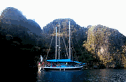
We continued across toward the Calamian group the next day. Dinakya Island offered a fine stop over for the night and would cut a few miles off the next day's sail. The Paradise Club behind a superb beach is of high standard with pricey meals. At nearby Maricaban there are secure moorings for yachts long term.
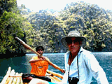
The Calamian Group of Islands is part of Northern Palawan Province. It consists primarily of Busuanga, Culion and Coron Islands. Illultuk is a landlocked bay on Calauit Island tucked into Busuanga's northern flank. During the Marcus era a game reserve was establisher there for African animals. Later it was used to protect and study some of the Philippine Island's own endangered species like the bear cat, mouse deer and fresh water crocodile. We found ourselves ashore feeding giraffes by hand and bumping along in the back of a dusty Landover to seek out other denizens of the reserve.
In the sounds between the many scattered offshore islets are acres of pearl farms. Long buoyed lines of oysters hand in deep water and must be carefully navigated around. This must be done in good light so the times that one can travel through the area are limited. We reached Capare Island at dusk and could simply go no further in poor light.
Conception Village on Busanga proved to be a reward spot. We spent a couple of days there. It had an amazing jungle waterfall and pool. We hauled our laundry up there to wash it in the most romantic setting imaginable. Swedish Mike and his Filipina wife have set up a guest house there where you are encouraged to keep Mike company with a lot of beer.
After a lazy morning we headed down the coast to locate the Tai Maru, a WWII ship bombed and sunk here by Americans. The wreck is about 190 meters long and we found it market, as most of them are here, with a white buoy at the shallow stern end and a red buoy at the bow, which lay in deep water. Michael and I went down but the tide had turned making visibility murky. We got underway again to negotiate the narrows between Lusand Island and Busuanga into Tangat Bay where another four or five wrecks are known to lie.
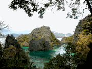
Tangat and the next island, another Apo, are steep rugged mountains of great scenic appeal. Offshore lay more islands, large and small. Between each were navigable passes and small sand cays or reefs. It would take years to discover all the wrecks, coves, beaches and reefs. It would be a nice place to hang out for awhile.
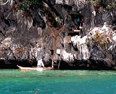
At the tip of Tangat Island is a resort run by "Andy and his girls" surrounded by spectacular mountains. Unfortunately the wind was onshore making it difficult to safely stop there. We diverted to the west side of the bay but found it deep right to the rock walls. Native families actually lived in limestone caves here with ladders down to their moored canoes. We anchored only with difficulty.
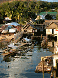
Magnificent Coron Island was visible to seaward as a solid rage of steep cliffs rising to innumerable peaks. By way of Mayanpayan Channel and Port Usuon we entered Coron Harbor. Coron municipality consists mostly of stilt houses perched over the water and nipa huts further island, is a community of 27,000. It lacks many modern amenities including supermarkets but has enough small shops and a lively fresh food market to satisfy most needs. We landed by dinghy at the steps of a three-story hotel called Sea Dive run by Jim, an
|
|